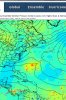
• Hello, please take a minute to check out our awesome content, contributed by the wonderful members of our community. We hope you'll add your own thoughts and opinions by making a free account!

Tropical TD 16

18Z GEFS is the least bearish run since the 6Z of yesterday:

KhpOJPV.png
 
Last edited:
95L bares watching but can someone make a thread for 96L because it could hit the OBX and is closer to us?
 
I wouldn't be surprised to see this get it's act together through the next 3-4 days before it hits a TUTT as its approaching the islands. After the tutt things may become a little more favorable if it's north of the islands but the overall development of 96L will potentially help determine track and intensity as it may leave a weakness in the ridge or have an outflow channel in 95Ls path. If 95L isn't directed OTS by that point it'll be a race between 95L and and troughing potentially moving into the eastern US. There are quite a few hurdles here but it's certainly worth watching
 
I got a feeling the SE COAST needs to watch this one.

I have a feeling that system ahead of 95L will get pulled north with the trough, and the ridge will re-establish itself over the West Atlantic. If not, then this is going to be one hell of a storm for Nova Scotia lol. I actually think this has a pretty good shot at the Carolinas. This storm is currently worth 5 - maybe 6 - percent of my attention.
 
gfs-ememb_lowlocs_watl_42.png

Gefs has the members split around D5, stronger members then hit the eject button and go ots. What's left ends up here I believe none of these actually hit the US
 
12z ICON and CMC still saying no to OTS.....CMC in a big way. The question is "will the ridge build back after 96L"?


Screenshot_1631734909441.png

Screenshot_1631734946747.png
 
Back
Top