• Hello, please take a minute to check out our awesome content, contributed by the wonderful members of our community. We hope you'll add your own thoughts and opinions by making a free account!

Severe Spring Severe Weather Thread 2017

NGA looks to be under the gun for severe tomorrow afternoon/ night
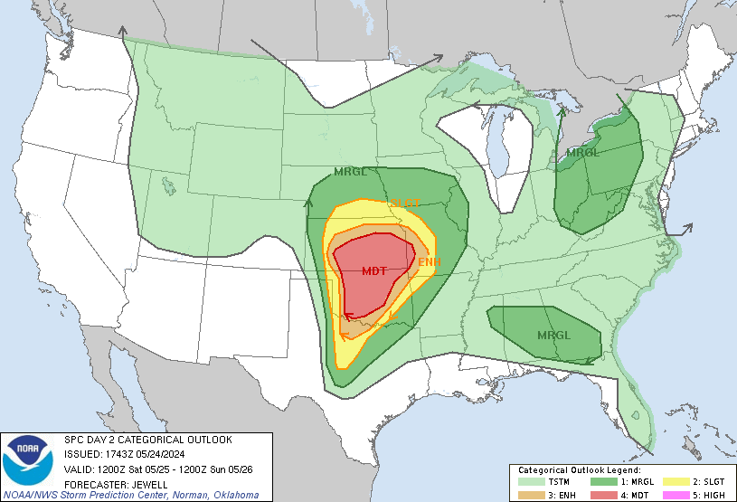
It's interesting setup for Severe weather for NGA sorta moving SE instead of what one would be more familiar with a NE storm track from the West, but SCape is definitely high for N. Georgia/Tennessee parts.

If shear was better in the area this most likely would've ramped very strongly..but doesn't look like much shear currently
 
day2otlk_1730.gif

Looks like the bumped up the threat for tomorrow
4k NAM looks a oriented differently on 18z compared to 12z run as far as storms at 23z?
 
day2otlk_1730.gif

Looks like the bumped up the threat for tomorrow
4k NAM looks a oriented differently on 18z compared to 12z run as far as storms at 23z?

Models keep shifting a little south with each run . That 4K run just takes it to another level with the shift


Sent from my iPhone using Tapatalk
 
NAM continues to show stronger storm signals for upper area of Georgia tomorrow, it's intensified each run and ticked further south on 4k and 3k runs, be interesting to see next couple of runs and HRRR
 
Not SE, but this is interesting to see. Despite the severe weather risk, we seem to have per SPC less of a tornado potential, none at all, than California. I rarely see any tornado risk out there.
day1probotlk_1200_torn.gif

Back to the SE, the HRRR is showing 2300+ SB CAPE in North Georgia later this afternoon and evening. There could be some nasty cells developing.
 
Last edited:
Not SE, but this is interesting to see. Despite the severe weather risk, we seem to have per SPC less of a tornado potential, none at all, than California. I rarely see any tornado risk out there.

Back to the SE, the HRRR is showing 2300+ SB CAPE in North Georgia later this afternoon and evening. There could be some nasty cells developing.
I don't think I have ever seen an enhanced risk of storms here with no threat of tornadoes.

day1otlk_1300.gif
 
Does anyone believe the Friday/Saturday outlooks will be expanded further North and East with time?
 
Yeah just reviewing the GFS looks like after today we have about 3 potential storms to track of a 10-11 day window, who knows if each of them actually hang around to bring severe weather to the South? But welcome to Spring and a active period to start
 
The one around next Monday has my eye. Wind fields are weak at this point, but that could end up a very nasty setup at quick glance.

There are actually two threats next week that could get out of hand. But your right about the first one . At least the pattern is active


Sent from my iPhone using Tapatalk
 
Not trying to look too far ahead but the pattern continues to look very active over the next ten days. Gonna have to watch all the systems as they roll through


Sent from my iPhone using Tapatalk
 
Models have really backed off for the Saturday threat the further east you east . Texas , Oaklahoma and Arkansas looked flavored for the first system . I for sure wouldn't say the severe threat is zero the further east you go but it's no doubt backed off


Also need to watch the system Monday into Tuesday . That one looks to have a little better wind profiles
Do you proof read your posts?
 
I think the model that was said " couldn't predict a sunrise " did fairly well with the placement of the MCS yesterday!!? And it showed the pop up storms around GSP and CLT yesterday evening, hours ahead of the MCS!
 
I think the model that was said " couldn't predict a sunrise " did fairly well with the placement of the MCS yesterday!!? And it showed the pop up storms around GSP and CLT yesterday evening, hours ahead of the MCS!


I said I wouldn't trust it to predict the sunrise. Trust me I've been burned by all versions of the NAM too many times exp the high RES versions.
 
Looks like the farther west you go the more likely the severe weather will be over the next few rounds. Farther east its a diminishing line of storms with meager rain totals
 
Looks like the farther west you go the more likely the severe weather will be over the next few rounds. Farther east its a diminishing line of storms with meager rain totals
These meager rain totals will be problematic as the drought continues to slowly expand....
 
Back
Top