• Hello, please take a minute to check out our awesome content, contributed by the wonderful members of our community. We hope you'll add your own thoughts and opinions by making a free account!

Misc Sizzling Shenanigans: warm season whamby

All of this is confusing. So the strongest winds will be on the east side and heaviest rain on the west side. Seems like the strongest winds would be in the area with the heaviest rain.

Well some of the rain on the west side is gonna be indirect and not even from Helene tbh. The fact there's a front and an upper low will enhance it
 
Opal had a 56 mph wind gust at the airport and they were on the east side then because the center was in Alabama

I think that's a fair analog as a worst case scenario

The NHCs point over Atlanta is only 35 mph. It goes from 120 to 35 mph in 12 hours... Even worse than that chart
 
Opal had a 56 mph wind gust at the airport and they were on the east side then because the center was in Alabama

I think that's a fair analog as a worst case scenario

The NHCs point over Atlanta is only 35 mph
I am 135 miles due south of Atlanta so I imagine the winds here would be a little higher. But I would still be to the west of the center if the latest GFS is right.
 
I get home and expecting some humidity like there was the entire way home from RDU, but no, smells like a desert outside. The humidity should be well into the 90s right now like it is literally everywhere else, no, 75%.

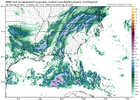
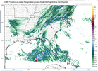
HRRR is already cutting for tomorrow, as one would expect.

00z
1727240146464.png
03z

1727240206341.png
 
I get home and expecting some humidity like there was the entire way home from RDU, but no, smells like a desert outside. The humidity should be well into the 90s right now like it is literally everywhere else, no, 75%.

HRRR is already cutting for tomorrow, as one would expect.

00z
View attachment 151721
03z

View attachment 151722
Maybe the Braves will get in a game after all tomorrow night.
 
I get home and expecting some humidity like there was the entire way home from RDU, but no, smells like a desert outside. The humidity should be well into the 90s right now like it is literally everywhere else, no, 75%.

HRRR is already cutting for tomorrow, as one would expect.

00z
View attachment 151721
03z

View attachment 151722
Would be good if we cut totals at this point. Don't need major flooding but definitely need to break the drought.
 
Would be good if we cut totals at this point. Don't need major flooding but definitely need to break the drought.
One wonders why there are literally thunderstorms happening all over the Carolinas and northeastern Georgia, and there is still this bubble of dry heat over top of us. It is going to take no less then what is coming to penetrate it. Models are showing this frontal interaction tomorrow, but we saw what happened with the last storm, so it wouldn't at all surprise me to see it stay completely dry in some areas until the actual tropical system gets in here.
 
One wonders why there are literally thunderstorms happening all over the Carolinas and northeastern Georgia, and there is still this bubble of dry heat over top of us. It is going to take no less then what is coming to penetrate it. Models are showing this frontal interaction tomorrow, but we saw what happened with the last storm, so it wouldn't at all surprise me to see it stay completely dry in some areas until the actual tropical system gets in here.
No doubt it's been way to dry so that may be a factor. Either way the heat is gone soon which is a relief.
 
I am 135 miles due south of Atlanta so I imagine the winds here would be a little higher. But I would still be to the west of the center if the latest GFS is right.
It depends on a lot of things, I live 100 miles due west of Hatteras and 110 miles north of Wilmington and Morehead/Atlantic Beach is only 60 or so mile away and I have been in a bunch of hurricanes/TS and only had gust above 70 mph in 4 of them....typically those wind maps are always overdone by a decent bit, that said if the storm is moving fast enough I can see gust 75-100 happening in the first 6 hrs after landfall especially if the eyewall is strengthening coming in.
 
No doubt it's been way to dry so that may be a factor. Either way the heat is gone soon which is a relief.
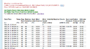
Cobb County is still reporting 66% humidity at 1AM, I don't even understand how that is physically possible with all the moisture in all directions.

1727241285227.png
 
That's the thing, the NBM is filtering out a bunch of crap and trying to take the best forecast it can. While the storm is a hurricane at landfall, the trajectory of ATL maybe not being on the east side is helping them out.

It doesn't matter, regardless, but just wanted to throw it out.. that some of these wind maps are absolutely horrible.

With the storm moving at a whopping ~25 mph, the west side has weaker winds than a storm of the same strength in the same position to the east moving at a slower speed. I bet that has a lot do with these models keeping ATL winds capped at barely TS strength. So, whereas the 25 mph movement doesn’t allow for much weakening of the highest winds (on E side…like ATL was for Opal) and also causes higher winds on the E side due to the forward speed, that same fast movement keeps the W side winds from getting too high unless perhaps one is located immediately W of the center.
 
Yall be safe down there the rest of this week! That is a doozy of a storm coming up, I hope it's just rain and some breezes! I got my fingers crossed in Maine that minimal damage occurs! Take care!!
 
That's the thing, the NBM is filtering out a bunch of crap and trying to take the best forecast it can. While the storm is a hurricane at landfall, the trajectory of ATL maybe not being on the east side is helping them out.

It doesn't matter, regardless, but just wanted to throw it out.. that some of these wind maps are absolutely horrible.
As of this morning my official FFC forecast has me gusting to 70 at the peak now so that isn't helping the other case for weaker.
 
Dang won’t take much more for Upstate SC to be out of it completely. Pretty hilarious and a sign of things to come for winter.
I mean you shouldn't be surprised. Not saying yet it's a non event. But wouldn't surprise me if more rain falls from the frontal interaction than the core of the storm itself. I get heat for downplaying events but that's usually what happens here.
 
I mean you shouldn't be surprised. Not saying yet it's a non event. But wouldn't surprise me if more rain falls from the frontal interaction than the core of the storm itself. I get heat for downplaying events but that's usually what happens here.
What’s bad is how much Chris Justus hyped it up yesterday. We are to the point around here where it would be best to get no heads up and just see what happens the day of.
 
All the posters in GA now.

Panic Omg GIF
 
Back
Top