NBAcentel
Member
If it’s already this bad just wait till NC/upstate of SC gets there mega CAD winter storm while it’s pouring and 34 in Atlanta
More like Atlanta gets the mega 40 degree rain and upstate gets the mega 34 degree rainIf it’s already this bad just wait till NC/upstate of SC gets there mega CAD winter storm while it’s pouring and 34 in Atlanta
La Niña dawg. Cold air intrusions are so much better during Nina’s because the Aleutian ridge can sometimes go poleward. Unlike the El Niño GOAK troughMore like Atlanta gets the mega 40 degree rain and upstate gets the mega 34 degree rain
That’s gotta be weird dating someone your daughters ageMy kid went to daycare with his daughter. His daughter is also 31 yrs old.
Yeah, but he will make special appearances.Didn’t he retire?
Power just came back on me for in Lilburn, NE of Atlanta. It went out around 4 am. Lots of flooding around the area. Not a lot of noticeable wind damage in my immediate vicinity though.I'm concerned about Atlanta, nobody is posting from there. Hope everyone is ok
Are we talking focus from posters here or the NHC and NWS? I have yet to hear or read of an area that was impacted that wasn't warned appropriately.As far as the snarky comments yesterday that's a totally different issue but yes at the end of the day I think there was way too much focus on Atlanta and not as much on how large the east side of this thing was... I mean there was surge on the Atlantic side of Florida from a storm in the Gulf. That is beyond crazy
Are we talking focus from posters here or the NHC and NWS? I have yet to hear or read of an area that was impacted that wasn't warned appropriately.
and then north of 40/85 rolls into take the stormIf it’s already this bad just wait till NC/upstate of SC gets there mega CAD winter storm while it’s pouring and 34 in Atlanta

Agreed, at least the NHC did put out a short statement on their forecast cone/track performance for Hurricane Helene.Guys this is a weather enthusiast board, and as such, we are allowed to bash nhc for their embarrassing short range cone placement. It doesn’t mean it had much impact to normal people. Normal people won’t even care or realize how badly the storm was forecasted bc the impacts were so wide ranging and severe.
From a public standpoint, they did fine. But from an actual forecasting standpoint… a blind monkey could have done better and we know what. It’s honestly not even comprehensible for us. I have literally no idea what they were looking at to make such a bad track/cone yesterday in to last night.
But then it turns to rain and sleet with Roxboro being the only exception.and then north of 40/85 rolls into take the storm


Snow?Classic example of what a -NAO should be doing instead of trapping lows around Hudson Bay View attachment 152215View attachment 152216
Wen?Snow?
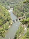
The Georgia Appalachian Trail Club is reporting that the AT bridge over the River in Erwin has been washed away, and that Uncle Johnny’s Hostel is also gone.

this is the bridge looking from Johnny's before it collapsed.


Yeah man. Putting Alabama in the forecast cone 24 hours out was a great forecast.Some folks need to go back and do some reading before they pop off and claim "MAJOR FAIL" by the NHC and NWS offices. Probably the same people claiming FAIL when they only get 2" instead of 4" of snow. Go back and look at the warning products issued ahead of time for Helene. People severely affected by the storm were warned days in advance. Stop paying so much attention to the cone and the prediction for the center of circulation. Hell, NHC even tells you on the product pages how to use each of the products.
having areas just south of Atlanta under a hurricane warning even after landfall was not a great forecastYeah man. Putting Alabama in the forecast cone 24 hours out was a great forecast.
No one is saying that, at least not that I'm aware of, and certainly not me. But I'd argue that the NHC and the NWS did their job of warning people appropriately in the locations affected and not a single person i've seen calling them out has yet to provide evidence to the contrary. Pointing out where a city (fortunately) didn't experience predicted full hurricane strength and instead lesser storm affects is not the the dis that people is.Yeah man. Putting Alabama in the forecast cone 24 hours out was a great forecast.
I'm trying to figure out why this bothers you so much. They messed up, simple as that.No one is saying that, at least not that I'm aware of, and certainly not me. But I'd argue that the NHC and the NWS did their job of warning people appropriately in the locations affected and not a single person i've seen calling them out has yet to provide evidence to the contrary. Pointing out where a city (fortunately) didn't experience predicted full hurricane strength and instead lesser storm affects is not the the dis that people is.
I was one of the only ones dead set on its actual track. The rest of the forum thought I was nuts for the most part.No one is saying that, at least not that I'm aware of, and certainly not me. But I'd argue that the NHC and the NWS did their job of warning people appropriately in the locations affected and not a single person i've seen calling them out has yet to provide evidence to the contrary. Pointing out where a city (fortunately) didn't experience predicted full hurricane strength and instead lesser storm affects is not the the dis that people is.
I'm bothered by the people who think the NHC and NWS are MASSIVE FAIL OMG THEY"RE TERRIBLE. For their own sake, they are fooling themselves and they may in the future mislead others to their detriment.I'm trying to figure out why this bothers you so much. They messed up, simple as that.


How was that president caught off guard? I can imagine because I see it on the local level. Local officials in businesses, utilities, and school systems make their own decisions based on NWS briefings. I often read the same briefings and then I have to wonder how the officials make some of the choices that they do. I can't speak to Dominion Energy, but there are all kinds of reasons they may have thought it wouldn't be so bad.I was one of the only ones dead set on its actual track. The rest of the forum thought I was nuts for the most part.
Our local news and the president of Dominion Energy even says it was worse than they expected.
How does a president of a major energy company get caught off guard if they did such a great job?
Almost refreshing on this side of it...These dews feel like ass.
Sent from my iPhone using Tapatalk

It's terribleThese dews feel like ass.
Sent from my iPhone using Tapatalk
We ARE talking about their cone. That's what you're not getting. You're arguing against something no one else is talking about. Did Augusta and Greenville have Tropical Storm warnings? Yes. Did they think the center would pass by them and they'd get the worst the NE quadrant had to offer? Absolutely not. The NHC had the track going through Atlanta which depicted the worst conditions being in Georgia. Most models (that we have access to) showed the track going East of their cone. The question is why did they have such a skinny cone and not expand it to at least show the possibility of the center heading toward SC so people would have been more aware of the possibility? Again, no one cares they were technically under a Tropical Storm warning. The public sees the cone and operates based on that guidance.No one is saying that, at least not that I'm aware of, and certainly not me. But I'd argue that the NHC and the NWS did their job of warning people appropriately in the locations affected and not a single person i've seen calling them out has yet to provide evidence to the contrary. Pointing out where a city (fortunately) didn't experience predicted full hurricane strength and instead lesser storm affects is not the the dis that people is.
The NHC does not arbitrarily adjust the size of the cone. In order to make the cone, the NHC forecasts the storm at a specific location. Then a circle is drawn around that forecast position based on the historical average error at that forecast time frame. At 12 hours, that radius is 26 miles, at 24 hours 41 miles and so on. This particular storm made the cone look skinnier than usual because the 12 hour position was so far from the 24 hour position due to the incredible forward motion.We ARE talking about their cone. That's what you're not getting. You're arguing against something no one else is talking about. Did Augusta and Greenville have Tropical Storm warnings? Yes. Did they think the center would pass by them and they'd get the worst the NE quadrant had to offer? Absolutely not. The NHC had the track going through Atlanta which depicted the worst conditions being in Georgia. Most models (that we have access to) showed the track going East of their cone. The question is why did they have such a skinny cone and not expand it to at least show the possibility of the center heading toward SC so people would have been more aware of the possibility? Again, no one cares they were technically under a Tropical Storm warning. The public sees the cone and operates based on that guidance.