tennessee storm
Member
maybe a better thread title for this month should have been... STORMY APRIL...


Not this time. It looks like the strength of the wedge has backed off quite a bit and that is why we were upgraded to slight today. In fact, earlier model runs showed that the wedge barely protected parts of NE Georgia.The wedge will weaken this squall line. I know in Atlanta it will. Well......a 75% chance anyways. The wedge always wins.

That looks like a decent line of storms. I am just hoping to hear some good thunder and have some nice lightning to sleep to. The past two systems have not done much near me. The one on Monday went just to my NE and got hoover, vestavia, hueytown, and a few others, but I hardly saw any rain drops.
Sent from my iPhone using Tapatalk
That looks like a decent line of storms. I am just hoping to hear some good thunder and have some nice lightning to sleep to. The past two systems have not done much near me. The one on Monday went just to my NE and got hoover, vestavia, hueytown, and a few others, but I hardly saw any rain drops.
Shouldn't you be worrying about wedding plans???? Lol just kidding
Yeah we had a loud one roll through two nights ago . I love when it storms at night . Hopefully you get some tonight
Sent from my iPhone using Tapatalk
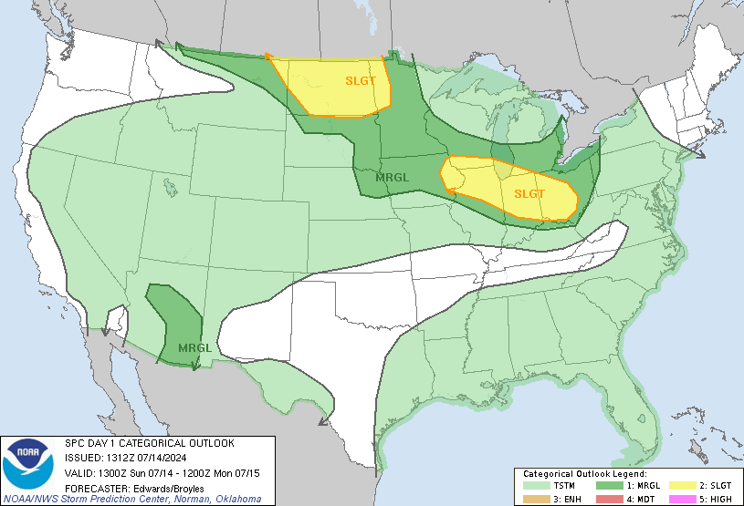
Yeah the clouds and lack of moisture return are really killer.Now the enhanced risk is totally out of Alabama, Mississippi, and most of Tennessee.
HRRR says stick a fork in it for Alabama, and it barely gets anything going in MS even.
JP Dice says threat is decreasing:
HRRR says stick a fork in it for Alabama, and it barely gets anything going in MS even.
JP Dice says threat is decreasing:
How's it looking for Georgia? Not seeing much info on that.

Rainy , the severe threat isn't impressive
Sent from my iPhone using Tapatalk

A closed mid/upper-level low will continue a slow general eastward
progression from the lower MO Valley and Ozarks toward the lower OH
River Valley through tonight. A related surface low will continue to
develop east-northeastward from east-central MO into central IL,
while a warm front advances northward across eastern IL and much of
IN/OH. Overall buoyancy will remain modest today and cloud cover has
remained semi-prevalent into midday across the warm sector. However,
some cloud breaks are noted near/just east of the MS River with
mid/upper 50s and some lower 60s F surface dewpoints otherwise
expected to expand northward in tandem with the warm front.
As gradual air mass destabilization occurs, storms may first
intensify across far eastern MO into southern IL just ahead of the
surface low and in concert with the aforementioned cloud breaks at
late morning. Additional warm sector or near-warm-frontal-related
development should also occur this afternoon into IN/OH this
afternoon, while other storms should form near the cold front across
KY/TN. While buoyancy will not be robust in most areas, long/largely
unidirectional hodographs, albeit with some near-1km AGL hodograph
curvature, will support a mixed mode including supercells and fast
northeastward-moving bows. Severe hail and damaging winds will be
possible, with a least some tornado risk as well, particularly near
the warm front where low-level SRH will be maximized.
...Gulf Coast States/lower MS River Valley...
12Z Upper-air data and contemporary surface observations/visible
satellite imagery show that considerable convective overturning has
occurred across parts of the region via an overnight/early morning
MCS. Ahead of a slow-moving convective cluster across southeast MS
and coastal eastern LA at late morning, the main severe risk should
be confined to far southeast MS into southern AL/FL panhandle and
eventually southwest GA. For additional short-term details, see
Mesoscale Discussion 377.
Farther west, in the wake of the early-morning MCS, some additional
development may occur near the north/south-oriented cold front this
afternoon. However, persistent cloud cover, modest
moisture/buoyancy, and limited near-frontal convergence all imply
that any near-frontal severe risk later this afternoon/evening
should remain limited across the lower MS Valley vicinity.
Yeah, the HRRR doesn't show that. I am going to just toss the HRRR.The line developing Memphis and north is starting to get its act together in North MS as well. Starting to rain on I55 in Hernando, MS.
I wouldn't do that. It isn't an exact presentation of what the radar looks like/will look like. It gives an idea. So far, it has handled the placement of the coastal convection better than other models like the 3km NAM.Yeah, the HRRR doesn't show that. I am going to just toss the HRRR.
The line developing Memphis and north is starting to get its act together in North MS as well. Starting to rain on I55 in Hernando, MS.
Yeah, right now that line is struggling to get going on the southern end in Mississippi. It's not really exploding or gaining much strength, at the moment.The problem is even if it gets going, winds through the column are veering unidirectional and the helicity isn't there. Low dps aren't helping.
OBs show the forming mesolow just off LA.


