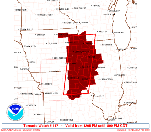
• Hello, please take a minute to check out our awesome content, contributed by the wonderful members of our community. We hope you'll add your own thoughts and opinions by making a free account!

Severe Severe Weather Threat April 2-3

At least there won't be a significant nighttime threat. I'm sure tomorrow is still going to be something, given the timing being in the hottest part of the day or do you think it may not?

Given that it's felt like summer to me lately, I think this reorganizes after the sun comes up. This might bust in Mississippi/Alabama, but we're far from knowing how conditions are in Georgia and eastward to make a judgment there (will it be sunny or cloudy/rainy at daybreak, how high are the dewpoints going to be, etc).

I know in the truly bad events it can stay strong at night, but I remember multiple strong/severe thunderstorm events recently (including last year) in which the sun goes down and poof. Now this won't go poof because its a big system, but the weakening doesn't really surprise me due to this.
 
SPC drops the Moderate Risk

day1otlk_1200.gif
 
T

To each his/her own....I like to watch the power of mother nature. The greatest days in weather are days like today here in AL....absolutely beautiful. The next greatest are days where mother nature puts on a show (without injury or destruction).
Agreed. That thunder and rain made for some great sleep last night. :)
 
Lots of flooding in Birmingham this morning as many locations have seen between 2-3 inches since 1am


Sent from my iPhone using Tapatalk
 
Looks way better from overnight I would say. Liking the heavy rain moving in this direction versus destructive winds.Don't like the reports flooding though that Storm5 mentioned.
 
Major reduction in the SPC this morning. Smaller enhanced area with no moderate. Hatched area is gone completely. Interested to see how it will respond with the daytime heating.
 
It's bad to bust on severe weather and it doesn't happen it's worst to bust on severe weather not happening and it then does, will see by end of day if results are more like yesterday outlook or today's outlook
 
It's bad to bust on severe weather and it doesn't happen it's worst to bust on severe weather not happening and it then does, will see by end of day if results are more like yesterday outlook or today's outlook

I completely agree. I would much rather see an Armageddon scenario on the SPC and then have some rain vs the opposite.
 
Need the storms to stay away from here around 11:30 tonight for the celebration on Franklin Street.
 
HRRR has couple of nice line segments moving across NC this evening.
Each successive run has the line holding together a little longer too.... And if correct it looks nasty around CLT right at rush hour
 
Each successive run has the line holding together a little longer too.... And if correct it looks nasty around CLT right at rush hour
We really need to get some moisture in here if we are going to see anything besides a few sprinkles. A dew of 44 ain't gonna cut it
 
Need the storms to stay away from here around 11:30 tonight for the celebration on Franklin Street.
I don't think it will be raining in Spokane tonight!! :(
 
A bust in Severe weather is never bad but as far as SPC and how Winter went as well... Beginning to wonder if we are gonna debate which season was biggest bust at this point Winter/Spring seems can't nail down anything 24 hours out
 
I think that the models should get a upgrade. There has been a LOT of busts lately.
 
We really need to get some moisture in here if we are going to see anything besides a few sprinkles. A dew of 44 ain't gonna cut it
41 up here but the HRRR is just about spot on right now with DP's and shows a strong surge or moisture in a few hours..... guess time will tell
 
We had one of those early cells and it was pouring hard early. Not sure where it went though.

Well, I think we have our answer. Its even cloudy here but it kinda looks like I'm right. Mississippi/Alabama, a total bust but a strong/severe line seems to be trying to set up in my eyes at the front of the system. Seems like it may just be the pop ups and that line, then just heavy rain in Georgia and South Carolina.
 
41 up here but the HRRR is just about spot on right now with DP's and shows a strong surge or moisture in a few hours..... guess time will tell

HRRR did a horrible job in my area as far as moisture surge goes . Maybe it will do better for your area . Let us know


Sent from my iPhone using Tapatalk
 
HRRR did a horrible job in my area as far as moisture surge goes . Maybe it will do better for your area . Let us know


Sent from my iPhone using Tapatalk
Well my gut tells me it is too fast with moisture return but we will keep ya posted....
 
Tornado Warning
Tornado Warning
GAC045-031530-
/O.NEW.KFFC.TO.W.0020.170403T1457Z-170403T1530Z/

BULLETIN - EAS ACTIVATION REQUESTED
Tornado Warning
National Weather Service Peachtree City GA
1057 AM EDT MON APR 3 2017

The National Weather Service in Peachtree City has issued a

* Tornado Warning for...
Central Carroll County in northwestern Georgia...

* Until 1130 AM EDT

* At 1056 AM EDT, a severe thunderstorm capable of producing a
tornado was located over Carrollton, moving northeast at 45 mph.

HAZARD...Tornado.

SOURCE...Radar indicated rotation.


* Locations impacted include...
Carrollton, Villa Rica, Abilene and Treasure Lake.
 
Tornado Warning
Tornado Warning
ALC045-031515-
/O.NEW.KTAE.TO.W.0058.170403T1448Z-170403T1515Z/

BULLETIN - EAS ACTIVATION REQUESTED
Tornado Warning
National Weather Service Tallahassee FL
948 AM CDT MON APR 3 2017

The National Weather Service in Tallahassee has issued a

* Tornado Warning for...
Northern Dale County in southeastern Alabama...

* Until 1015 AM CDT

* At 948 AM CDT, a severe thunderstorm capable of producing a tornado
was located near Ozark, moving east at 45 mph.
 
And one more in Ga...

Tornado Warning
Tornado Warning
GAC223-031530-
/O.NEW.KFFC.TO.W.0021.170403T1500Z-170403T1530Z/

BULLETIN - EAS ACTIVATION REQUESTED
Tornado Warning
National Weather Service Peachtree City GA
1100 AM EDT MON APR 3 2017

The National Weather Service in Peachtree City has issued a

* Tornado Warning for...
Southern Paulding County in northwestern Georgia...

* Until 1130 AM EDT

* At 1100 AM EDT, a severe thunderstorm capable of producing a
tornado was located near Draketown, or 8 miles southwest of Dallas,
moving northeast at 65 mph.

HAZARD...Tornado.

SOURCE...Radar indicated rotation.
 
Tornado Warning
GAC223-031530-
/O.NEW.KFFC.TO.W.0021.170403T1500Z-170403T1530Z/

BULLETIN - EAS ACTIVATION REQUESTED
Tornado Warning
National Weather Service Peachtree City GA
1100 AM EDT MON APR 3 2017

The National Weather Service in Peachtree City has issued a

* Tornado Warning for...
Southern Paulding County in northwestern Georgia...

* Until 1130 AM EDT

* At 1100 AM EDT, a severe thunderstorm capable of producing a
tornado was located near Draketown, or 8 miles southwest of Dallas,
moving northeast at 65 mph.

HAZARD...Tornado.

SOURCE...Radar indicated rotation.

IMPACT...Flying debris will be dangerous to those caught without
shelter. Mobile homes will be damaged or destroyed.
Damage to roofs, windows, and vehicles will occur. Tree
damage is likely.

* Locations impacted include...
Dallas, Hiram, New Hope and New Georgia.

PRECAUTIONARY/PREPAREDNESS ACTIONS...

TAKE COVER NOW! Move to a basement or an interior room on the lowest
floor of a sturdy building. Avoid windows. If you are outdoors, in a
mobile home, or in a vehicle, move to the closest substantial shelter
and protect yourself from flying debris.

If you see wind damage...hail or flooding...wait until the storm has
passed...and then call the National Weather Service toll free
at 1 8 6 6 7 6 3 4 4 6 6 or tweet us your report at NWSATLANTA.

&&

LAT...LON 3399 8490 3399 8475 3382 8474 3380 8496
3381 8501 3384 8504 3386 8504
TIME...MOT...LOC 1500Z 229DEG 57KT 3386 8497

TORNADO...RADAR INDICATED
HAIL...0.00IN
 
I wonder if anything touched down with the warnings to our west? Surprised this is happening since they lowered the risk today.
 
I wonder if anything touched down with the warnings to our west? Surprised this is happening since they lowered the risk today.

No kidding! They took this area down to a slight and that's where the worst is for the time being. I'm surprised. Torcon is very low at a 3 as well, was a 5 yesterday.
 
Back
Top