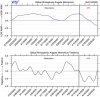
As was the Lee county EF4 last year. This sounding is for near BHM. A more organized system with these background numbers right here and it is a high impact event.
View attachment 39468
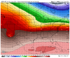
12z UKMet. Low level lapse rates need improving, but that is a nasty sounding if it does. If these trends continue, everyone will get their fill of discrete supercells.
View attachment 39470
Moving these two posts here.