Brent
Member
Come on snow we don't need any warm nose 
Enjoy, and keep us updated!Looks like we're starting as snow so far
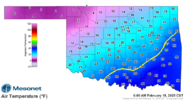
Alright, it is just after 6:00 AM and here are the temperatures currently according to the mesonet.I’m very curious to see how the temperatures will perform relative to the forecast given the Arctic air moving in. To do this, I will list the NWS forecast temperature and the latest HRRR run for 12z tomorrow (6:00 a.m.) at OKC and Tulsa. Also, these will be from the airports.
These are the current numbers:
OKC 2/18 12z:
NWS: 29
22z HRRR: 22
Tulsa: 2/18 12z:
NWS: 27
22z HRRR: 24
I will reply to this message a little after 6:00 AM with what the actual temperature is at these locations.


Hopefully the radar starts filling in. It looks like the bulk of the snow is North and East of Tulsa.Dry powder alert

Hopefully the radar starts filling in. It looks like the bulk of the snow is North and East of Tulsa.
Looks like NWS going 4-6" of snow? Looks like 12z Euro printed 4"....good luck!
Looks like NWS going 4-6" of snow? Looks like 12z Euro printed 4"....good luck!
And looks like Euro has been printing 4" for Tusla for several days now. But Kuchera ratios are higher it looks like.
View attachment 170423
Raleigh hasn't had a 4" event in 7 years...great to see it does snow in locations.NWS has been floating between 6-7 since 4am
TV 4-8 inches
Raleigh hasn't had a 4" event in 7 years...great to see it does snow in locations
Wichita is busting high right nowEh I don't know if I would declare a bust yet... I guess maybe if you're to my south. I still think once the sun goes down it's gonna pick up more
View attachment 170473View attachment 170474
I think a big issue last night is well known people were posting model runs with 8-12 inches
I always had a worst case scenario and I still think we're gonna end up close to it
Heck it's not even over yet and the sun is going down
Is the issue out there that the heavy precip developed too far north of you (and I guess a little north of at least where the most optimistic models were showing it)?
