• Hello, please take a minute to check out our awesome content, contributed by the wonderful members of our community. We hope you'll add your own thoughts and opinions by making a free account!

Pattern Outside of the SE thread

Forecast high today was 55 and its still only 43 and cloudy. Been the story of the week ever since Tuesday.
 
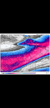
Tuesday-Wednesday looking more and more interesting. Also some possibility of another system next weekend.
1738989884720.jpeg
 
Within a day or two of each other, the big 3 have this! Shortwaves have not been sampled yet! 😉IMG_9298.pngIMG_9296.pngIMG_9297.png
 
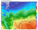
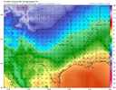
Interesting thing I am noticing in modeling for Wednesday system. Euro AI is several degrees cooler than the GFS and Euro. The AI is showing OKC in the mid 20s during the precipitation vs the Euro and GFS in the low to mid 30s1739156139560.png

Euro AI nailed the stronger extent of the low level cold air last week compared to other models. This leads me to believe it may be onto something here as well.
 
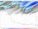
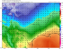
For being 48 hours away the 06z Euro AI and 12z GFS are quite a bit different from each other for Wednesday morning. I have not yet seen the 12z Euro AI but it has been very consistent so far on being much colder than other models.

12z GFS:
1739216304881.png

06z Euro AI:
1739216325887.png

I have seen a lot of talk about OKC and even Tulsa being on the border for any winter precipitation at all now. However, I do suspect its possible the other models are underestimating the low level cold air. Euro AI did win a similar battle last week. Very interested to see what wins out as it will make a massive difference compared to last week given the precipitation moving in.
 
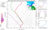
There is gonna be a bit of elevated instability when the precipitation moves through overnight. I think there is gonna be a chance for some thundersleet in some areas.
 
Back
Top