BufordWX
Member
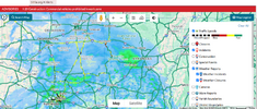
I would bet given the current trends that the Winter Storm Warning in OK is probably gonna get extended to the NW overnight. Dont know if they would go all the way to OKC or Tulsa with it just yet, but they may be playing catch up tomorrow.Literally what is happening
The heavy snow in Arkansas is now pretty much over me on the GEFS
As far as I know all the schools are open tomorrow still
View attachment 161632
Are they planning to get students early?Things definitely escalating here... School didn't close View attachment 161791
We still hate youThings definitely escalating here... School didn't close View attachment 161791
Yup, just saw OKC was upgraded to a Winter Storm Warning. Wouldn’t surprise me to see one for Tulsa eventually either.Things definitely escalating here... School didn't close View attachment 161791
Yup, just saw OKC was upgraded to a Winter Storm Warning. Wouldn’t surprise me to see one for Tulsa eventually either.


What about the kids in school?Lol finallyView attachment 161908
What about the kids in school?


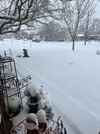
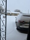
Same area now reporting 6”. Forecast around this area was only 2-3” yesterday. Massive overperformer, and it’s not done yet.Already seen a report of 2.5” a few miles south of Norman.


