Drizzle Snizzle
Member
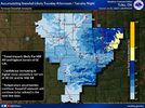
Looks like higher elevations in Arkansas do well.Tulsa is not impressed View attachment 130866
Looks like higher elevations in Arkansas do well.Tulsa is not impressed View attachment 130866
To be fair, we are running a fine line here with temperatures only marginally supportive of snowfall. Models ticking just a bit south with the precipitation the last 24 hours hasn’t helped either since we will need some heavier precipitation to help cool down that little bit we will need for snow.Tulsa is not impressed View attachment 130866
Is this near West Yellowstone Montana ?I snowmobiled up Mt Two Top in Idaho today. I really, really need to move out west. I'm dreading coming home tomorrow View attachment 130877
Yeah, the trail starts in West Yellowstone but Two Top is in IDIs this near West Yellowstone Montana ?
We rented a cabin around rexburg this summer and spent a lot of time up there and in Teton. I keep trying to figure out ways to get back. A buddy of mine moved to Thermopolis so now I have a place to stay.Yeah, the trail starts in West Yellowstone but Two Top is in ID
That's awesome. I've been four of the past five winters. I love it here. I've heard summer is a bit of a pain with the amount of tourist. How was it when you came during summer?We rented a cabin around rexburg this summer and spent a lot of time up there and in Teton. I keep trying to figure out ways to get back. A buddy of mine moved to Thermopolis so now I have a place to stay.
We went in early June when they first opened up so it wasn’t bad at all. It was 40s and 50s with snow in the mountains so it timed out perfect. Yellowstone lake still had a lot of ice. It was weird leaving 90 in Atlanta and going to hoodies and jackets. I did miss the humidity which I found strange.That's awesome. I've been four of the past five winters. I love it here. I've heard summer is a bit of a pain with the amount of tourist. How was it when you came during summer?
To be fair, we are running a fine line here with temperatures only marginally supportive of snowfall. Models ticking just a bit south with the precipitation the last 24 hours hasn’t helped either since we will need some heavier precipitation to help cool down that little bit we will need for snow.
Ole convection robbing moisture look ?
You know it’s a tough forecast when even different CWA don’t agree on snow totals.View attachment 130956

road trip to the Walmart headquarters in Bentonville ?Tulsa is bullish not far east of here View attachment 130983
road trip to the Walmart headquarters in Bentonville ?
More storms have missed me this winter by sliding South 2-3 days out! Good luck on this storm! Hoping it hooks NW some, to get me in the game.Honestly I wouldnt be surprised if if shifts overhead tbh they always seem to shift last minute and more south doesn't seem likely with temps so borderline
It’s becoming hard to ignore all these models going crazy with the snowfall for Tuesday. Even if you lower the output totals some due to snow ratios and ground temperatures you likely still end up with several inches. It’s not just one or two models showing this either which only makes things more interesting. The Euro still worries me a bit since it has been further south, but it’s pretty much on an island of its own if you look at everything else.No doubt there's been an uptick on the models tonight howeverView attachment 131000
I think there are already Winter Storm Watches from Fayetteville to St Louis.It’s becoming hard to ignore all these models going crazy with the snowfall for Tuesday. Even if you lower the output totals some due to snow ratios and ground temperatures you likely still end up with several inches. It’s not just one or two models showing this either which only makes things more interesting. The Euro still worries me a bit since it has been further south, but it’s pretty much on an island of its own if you look at everything else.
I wonder if the NWS is gonna end up issuing Winter storm watches overnight? At the very least we should get an Advisory sometime tomorrow.
I was watching a weather guy from NWA and he was saying these will be really fat flakes. Not the pixie dust flakes.
