Made it to 18F! First teens since early Jan ‘18
-
Hello, please take a minute to check out our awesome content, contributed by the wonderful members of our community. We hope you'll add your own thoughts and opinions by making a free account!
You are using an out of date browser. It may not display this or other websites correctly.
You should upgrade or use an alternative browser.
You should upgrade or use an alternative browser.
Ostrich December
- Thread starter SETNwx
- Start date
NBAcentel
Member
Warm sector, shear, fun3 different models valid at the same timeView attachment 60385View attachment 60386View attachment 60387
Only thing not lookin to impressive severe wise is the CMC given the forcing moves away and we only get a weak line of showers
16 on the weatherflow 18 on my davis.@SD I have a hunch your station was reading like 12 degrees this morning or something. What was the morning low?
Interestingly the weatherflow fell quickly then leveled off while the Davis had a more gradual fall.
Last edited:
LickWx
Member
That sounds not as bad as I thought I legit believed you would report like 12 lol. Sounds reasonable , Sanford was 18 , Roxboro 19 , and Harnett county airport 24.16 on the weatherflow 18 on my davis.
Interestingly the weatherflow fell quickly then leveled off while the Davis had a more gradual fall.
D-Ray
Member
16 this morning.....it never made it this low all of last winter !!!!
Almost...


olhausen
Member
High Christmas Day was 23.5 degrees and the low was 14 which actually happened last night around 10pm. Temps actually went up to 17 in the overnight hours before the sun came up and now sitting at 46. Even so last year I managed 13.6 for my lowest low and that was in mid November when winter pulled a head fake on us.
Brent
Member
December's last cold rain?
Colder temperatures will arrive behind a Canadian front during
the day Wednesday and persistent cold advection will send temps
down into the 30s areawide by Thursday morning. Uncertainty on the
upper level trough position increases during this time range with
the NBM suggesting increasing snow potential Wednesday night.
Cluster analysis of the ensemble data indicate that about a third
of the members (half of them from the Euro) show a deeper and
slower trough which would increase the chance of precipitation in
the colder airmass. Have included a slight chance mention of rain
and snow mix across the northeastern zones where the juxtaposition
of cold air and precip appears to be highest at this time.
FWIW, the 12z EURO was closer to looking like the GGEM
It was a beautiful day for cutting firewood. 44 with a thawing ground, bluebird skies, and copious trees left by the hurricane. We had a huge flock of sandhill cranes fly over which is very odd this late in the year. Usually they have all passed south by early December.
Brent
Member
It's back? It was there a few days ago then trended to a stormy setup lol
Brent
Member
I swear if we miss to the south again...

I had a 2nd in a row night walk with it at quite an invigorating ~32 F, which is either at or just above the coldest I can recall for walks at this location. However, when considering wind chill, I’m assuming neither is the coldest as I’m sure I’ve walked here in 20s wind chills in the past and the last two days' walks had near calm winds.
This Dec has certainly been no ostrich and has actually been the opposite!
This Dec has certainly been no ostrich and has actually been the opposite!
Last edited:
LickWx
Member
A very non warm December . For the first time in 15 years we did not have a day break 70 in RDU. Normally December sees 3 days above 70 with a mean max of 73. This year thanks to low energy weather as I like to call it and being screwed over with some sorta cold hole over Roxboro to RDU the warm day this month was only 69 . Last time we didn’t see 70 in December was 2005, 2 years after that though we hit 81 in December 2007!
Now the even more impressive news ! For the first year since 1956 we did not drop below 20! It has been 64 years ! We had other years such as 1949, 1939, 1931, 1915, 1913, 1911, and 1890 that did not drop below 20 the entire year . Used to be more common in the past, 2012 came close but it dropped to 19. We have had winters such as 2005-2006 not drop below 20 but years not since 1956. Looks like years that don’t drop below 20 happened close to each other in the past , yumm! Maybe more on the way. Mean minimum for December last 30 years is 20 , we dropped to that exactly this month which was also the coldest of the whole year.
Now the even more impressive news ! For the first year since 1956 we did not drop below 20! It has been 64 years ! We had other years such as 1949, 1939, 1931, 1915, 1913, 1911, and 1890 that did not drop below 20 the entire year . Used to be more common in the past, 2012 came close but it dropped to 19. We have had winters such as 2005-2006 not drop below 20 but years not since 1956. Looks like years that don’t drop below 20 happened close to each other in the past , yumm! Maybe more on the way. Mean minimum for December last 30 years is 20 , we dropped to that exactly this month which was also the coldest of the whole year.
Don't sleep on not hitting 70 yetA very non warm December . For the first time in 15 years we did not have a day break 70 in RDU. Normally December sees 3 days above 70 with a mean max of 73. This year thanks to low energy weather as I like to call it and being screwed over with some sorta cold hole over Roxboro to RDU the warm day this month was only 69 . Last time we didn’t see 70 in December was 2005, 2 years after that though we hit 81 in December 2007!
Now the even more impressive news ! For the first year since 1956 we did not drop below 20! It has been 64 years ! We had other years such as 1949, 1939, 1931, 1915, 1913, 1911, and 1890 that did not drop below 20 the entire year . Used to be more common in the past, 2012 came close but it dropped to 19. We have had winters such as 2005-2006 not drop below 20 but years not since 1956. Looks like years that don’t drop below 20 happened close to each other in the past , yumm! Maybe more on the way. Mean minimum for December last 30 years is 20 , we dropped to that exactly this month which was also the coldest of the whole year.
This is cool, and great info! Thanks for digging this up!A very non warm December . For the first time in 15 years we did not have a day break 70 in RDU. Normally December sees 3 days above 70 with a mean max of 73. This year thanks to low energy weather as I like to call it and being screwed over with some sorta cold hole over Roxboro to RDU the warm day this month was only 69 . Last time we didn’t see 70 in December was 2005, 2 years after that though we hit 81 in December 2007!
Now the even more impressive news ! For the first year since 1956 we did not drop below 20! It has been 64 years ! We had other years such as 1949, 1939, 1931, 1915, 1913, 1911, and 1890 that did not drop below 20 the entire year . Used to be more common in the past, 2012 came close but it dropped to 19. We have had winters such as 2005-2006 not drop below 20 but years not since 1956. Looks like years that don’t drop below 20 happened close to each other in the past , yumm! Maybe more on the way. Mean minimum for December last 30 years is 20 , we dropped to that exactly this month which was also the coldest of the whole year.
In a very wet year, it does seem fitting we close it out with yet another heavy rainfall
CHA needs 1.09" to break the all-time record of 73.70" set in 1994. Looks like a very solid chance that we pull it off.

CHA needs 1.09" to break the all-time record of 73.70" set in 1994. Looks like a very solid chance that we pull it off.
holy.....
edit: is the fact that both highs mentioned in that tweet formed in Siberia a coincidence? If not, why might that area get extremes like that?
edit: is the fact that both highs mentioned in that tweet formed in Siberia a coincidence? If not, why might that area get extremes like that?
holy.....
edit: is the fact that both highs mentioned in that tweet formed in Siberia a coincidence? If not, why might that area get extremes like that?
What's even more amazing is they set some all time record high temps this summer..
Only two days below normal from this short-lived Arctic blast:
| 2020-12-20 | 52 | 42 | 47.0 | 5.4 | 18 | 0 | 0.03 | 0.0 | 0 |
| 2020-12-21 | 58 | 40 | 49.0 | 7.6 | 16 | 0 | 0.00 | 0.0 | 0 |
| 2020-12-22 | 60 | 36 | 48.0 | 6.7 | 17 | 0 | 0.00 | 0.0 | 0 |
| 2020-12-23 | 61 | 31 | 46.0 | 4.8 | 19 | 0 | 0.03 | 0.0 | 0 |
| 2020-12-24 | 55 | 29 | 42.0 | 0.9 | 23 | 0 | 1.67 | T | 0 |
| 2020-12-25 | 30 | 22 | 26.0 | -14.9 | 39 | 0 | T | T | 0 |
| 2020-12-26 | 46 | 19 | 32.5 | -8.3 | 32 | 0 | 0.00 | 0.0 | 0 |
| 2020-12-27 | 58 | 25 | 41.5 | 0.8 | 23 | 0 | 0.00 | 0.0 | 0 |
It's pouring
Shaggy
Member
It's pouring
Wedge front pushed east and Washington went from 71 to 57 in one obs. Cane with a decent downpour
Attachments
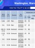
How brutal is that. Oh it's so nice today....OVERWedge front pushed east and Washington went from 71 to 57 in one obs. Cane with a decent downpour
Shaggy
Member
How brutal is that. Oh it's so nice today....OVER
I'm literally on the edge of the front. We were just in town and it was 64. Drove back under the heavy cloud deck and at my house just 6 miles or so from where we ate and my house is 58.
If you’re on Instagram go look at txheritage. Dude lives in Menard Texas and they got hammered with ice this morning. Live oaks and ice don’t mix at all!


BN Dec baby!
Highest Temp: 70F
Lowest Temp: 18F
Avg High: 53.5F (-0.5F)
Avg Low: 33.5F (-0.5F)
Monthly rain: 3.65” (-0.46 BN)
YTD rain (final total): 69.58” (+22.39”)
for the year
Highest temp: 96F
Lowest temp: 18F
69.58” of rain
Don’t have yearly temp averages because I only have data 5/1–12/31
Highest Temp: 70F
Lowest Temp: 18F
Avg High: 53.5F (-0.5F)
Avg Low: 33.5F (-0.5F)
Monthly rain: 3.65” (-0.46 BN)
YTD rain (final total): 69.58” (+22.39”)
for the year
Highest temp: 96F
Lowest temp: 18F
69.58” of rain
Don’t have yearly temp averages because I only have data 5/1–12/31
I didn't hear anything, but it seems as though we had some thunder and lightning with the rain this evening.
NBAcentel
Member
Some hail reports as wellI didn't hear anything, but it seems as though we had some thunder and lightning with the rain this evening.
NoSnowATL
Member
Man is this rain ever going to make it. Feels like it’s a few days late.
My house:
Average Low: 35.0F
Average High: 53.3F
Snow: (T) on four separate days
Precip: 3.74"
YTD Precip: 87.74"

Average Low: 35.0F
Average High: 53.3F
Snow: (T) on four separate days
Precip: 3.74"
YTD Precip: 87.74"
Dewpoint Dan
Member
I'm trying to figure out how it's possible for you to have 20" more rain than Atlanta this year. Your backyard must be the new state record for rainfall.My house:
Average Low: 35.0F
Average High: 53.3F
Snow: (T) on four separate days
Precip: 3.74"
YTD Precip: 87.74"
View attachment 61420
I bet there were some summer thunderstorms in his area compared to Atlanta because the higher elevation. Its doable.I'm trying to figure out how it's possible for you to have 20" more rain than Atlanta this year. Your backyard must be the new state record for rainfall.
Good chance. I'll add mine up tomorrow I have the water year resetting on 10/1I wanna bet I got more than 10+ Inches of rain then @SD
Dewpoint Dan
Member
I mean he's like 100 feet higher than Atl. Not sure that's enough to make a 20" difference.I bet there were some summer thunderstorms in his area compared to Atlanta because the higher elevation. Its doable.
Dewpoint Dan
Member
I bet you are at least 100 miles from SD also. J.C. is like 30-40 miles from Atl airport so a 20" rainfall difference would be incredible over that short distance.I wanna bet I got more than 10+ Inches of rain then @SD
I bet you are at least 100 miles from SD also. J.C. is like 30-40 miles from Atl airport so a 20" rainfall difference would be incredible over that short distance.
I’m sure there are stations with even more than that. I’ll look around when I get a minute and post the links.