• Hello, please take a minute to check out our awesome content, contributed by the wonderful members of our community. We hope you'll add your own thoughts and opinions by making a free account!

Pattern Oppressive Ornery Obstinate Opposite October

I'm not going to say this winter will be below normal, above normal or normal. Nothing is set-in-stone in the weather field, days and or months ahead. I'm not a big fan of seasonal outlooks, because there is very limited skill.

Of course, we have idea's of how the winter will turn out, but nothing is guaranteed. You can throw out possibilities all day long, but at the end of the day, we go along of what the weather brings and forecast it at the best of our abilities.

Enjoy the journey of this winter. We just don't know how the winter will exactly be like.


Sent from my SM-J327T1 using Tapatalk
 
Euro and NAM both showing maybe a couple inches of snow in parts of the Ohio Valley. But will it stick?
I doubt there will be widespread snow accumulation there. It's a cold air chasing moisture scenario. Most of the moisture will be gone by the time the cold enough air arrives to support snow. The mountains across TN/NC could see some flurries. WV could see some decent snow accumulations though.

Sent from my SM-J327T1 using Tapatalk
 
The Canadian snow pack is just as important . I'm good with a Nina pattern in November. Build that damn snow pack!!!
I honestly believe the snowpack in Canada has more of an impact on us than in Siberia. Getting a bank of cold air on this side of the world matters more because the air travels a shorter distance and cools the Upper US, and if we can get a snowpack well into the US as well, a cold winter would be easier by that argument.
 
I honestly believe the snowpack in Canada has more of an impact on us than in Siberia. Getting a bank of cold air on this side of the world matters more because the air travels a shorter distance and cools the Upper US, and if we can get a snowpack well into the US as well, a cold winter would be easier by that argument.

Actually, after the last few years, the correlation of October Siberian snowfall (SAI, etc) to our winters (technically it is to the winter's AO, which were clear fails in recent years) has to be questioned. The SAI failed pretty badly the last few years if I'm recalling correctly. Is there still that strong of a correlation when including these recent failures?
 
Actually, after the last few years, the correlation of October Siberian snowfall (SAI, etc) to our winters has to be questioned. The SAI failed pretty badly the last few years if I'm recalling correctly. Is there still that strong of a correlation when including these recent failures?
Yeah, I don't trust the Siberian snow cover idea much anymore and would like really like to hear other correlations versus the Siberian snow cover all the time. Also, we had Indonesian convection apparently mess us up last year, so any little thing could throw the perfect setup off.
 
Webber, the only reason you think k December may be the coldest month is because of climo? We had a +QBO in December and it was pretty cold and early January. Now, with total opposite QBO, are you thinking there won't be much difference for Dec and Jan, despite the -QBO compared to last winter?
 
Per the link below, the Arctic north of 80W has cooled much more rapidly over the last 11 days than normals cool, from ~17F to ~0F, including about a 2.5 F cooling just during the last 24 hours. So, it cooled ~17 F, while normals cooled only ~5.5 F (~0.5 F/day) during the last 11 days. Normal today is ~-5 F. Normal 11 days ago was ~+0.5 F.

As mentioned, it is now near 0F. Last year on this day it was +8F and it then rose to a whopping +23 F 11/20/16!! It didn't finally get down to 0 F last year until near December 1st!! It then rose back up to +12 F just before Christmas when normals are -19 F...yes 31 F above normal in the Arctic just before Christmas of 2016!! One might assume the AO was very negative then. No, it was actually VERY positive at ~+4!! Knowing this, it is no surprise last winter was so warm in so much of the country with such a warm Arctic source region though the upper air pattern is normally by far the biggest factor and probably was last winter.

AO 2016 12 23 3.807

2017: http://ocean.dmi.dk/arctic/plots/meanTarchive/meanT_2017.png

2016: http://ocean.dmi.dk/arctic/plots/meanTarchive/meanT_2016.png

**Edited again
 
Last edited:
I actually don’t like this discussion. When people start Cherry picking others comments it turns some of us off. More importantly it may even lead to scaring some into not posting on our forum.


Sent from my iPhone using Tapatalk
I was only being funny. Someone around here has to have a since of humor
 
It would be funny if after all of this warm November discussion that it ends up near normal or colder in the SE. To clarify, I'm not forecasting that.
While I think the month ends up AN I'm interested in the middle of the month. The PV might try to slip until the hudson bay area and the pacific trough flatten a bit. While it still favors AN the potential is there for a front or 2 to slip into the region maybe even some type of wedge

Sent from my SM-G955U using Tapatalk
 
Webber, the only reason you think k December may be the coldest month is because of climo? We had a +QBO in December and it was pretty cold and early January. Now, with total opposite QBO, are you thinking there won't be much difference for Dec and Jan, despite the -QBO compared to last winter?
Not climo, but climatological progression of La Niña winters... Their modulation of the NAM is s.t. our winters start out seasonable to cold in November and December and become progressively warmer as we get deeper into winter because on the whole, their quasi stationary forcing induces a Rossby wave pattern that interferes with the mean standing planetary wave configuration, which ultimately allows the polar vortex to intensify over the course of the winter >>> higher +NAO/+AO esp in/around February
 
If it's going to really warm up in February...I wonder if, just considering how warm vs cold can really clash, the best chance for a winter storm comes in January/early February (early February through a front).
 
If it's going to really warm up in February...I wonder if, just considering how warm vs cold can really clash, the best chance for a winter storm comes in January/early February (early February through a front).
La Ninas are notorious for unusually early season severe weather outbreaks especially over the lower Mississippi and Tennessee Valleys (Super Tuesday February 2008 for ex) due in part to the aforementioned warm up over the SE US late in the winter that leads to a very strong baroclinic zone over the central part of the country as Cp & arctic airmasses continue to flood the Pacific NW, northern Rockies, & upper Midwest which leaves a lot of potential barortropic (conversion of basic state kinetic energy into available eddy kinetic energy) and baroclinc energy conversion (conversion of basic state available energy into eddy available energy) to be had for any incipient disturbance that becomes entrained into this sort of pattern. Essentially the difference between barotropic energy conversion and baroclinic energy conversion is that the former (barotropic energy conversion) relies on pre-existing energy (derived from the kinetic energy of the background flow, very common form of energy conversion in the tropics, wherein there exists little-no temperature gradients (& thus little potential energy) & it's also observed in the mid latitudes due to waves leaning against the bgd shear (negatively tilted (NW-SE orientated waves south of the jet, north of the jet core, barotropic energy conversion actually favors positively tilted waves). Baroclinic energy conversion, one many are often more inherently familiar with, is a more fancy way of saying that pre-existing temperature gradients (which also implies density gradients) leave a lot of potential energy to be had and the Rossby Waves we observe on a day-to-day basis convert this potential energy into a more useable form (I.e Eddy potential energy) which is realized as a strengthening low or high pressure system (in a general sense)
 
Last edited:
Short lived, but beautiful incoming, IMHO ...

currad2.png


curtmp.png
 
Looks like there is a chance for severe storms today down east.

Hazardous Weather Outlook
National Weather Service Raleigh NC
536 AM EDT Sat Oct 28 2017

Warren-Halifax-Franklin-Nash-Edgecombe-Wake-Johnston-Wilson-Harnett-Wayne-Cumberland-Sampson-
536 AM EDT Sat Oct 28 2017

This Hazardous Weather Outlook is for central North Carolina.

.DAY ONE...Today and Tonight.

Showers and isolated thunderstorms are expected to move onshore over northeastern SC and southeastern NC late this evening, then spread along and east of the Interstate 95 corridor late tonight through Sunday morning. The strongest storms will be capable of producing damaging wind gusts or an isolated tornado.

.DAYS TWO THROUGH SEVEN...Sunday through Friday.

West to northwesterly winds will become blustery behind a cold front Sunday afternoon through at least early Sunday night, with peak wind gusts during that between 30 and 40 mph.

.SPOTTER INFORMATION STATEMENT...

Spotter activation may be needed between 11 PM tonight and 8 AM Sunday morning.
 
18z 12km NAM is likely over doing the snow across the higher elevations of TN/NC/WV and VA. However, snow flurries and snow showers with some accumulation is not out of the question. The highest snow accumulations will be along the NW/western facing slopes of the highest elevations.


8b9c5d2896530fd08c1ab785f0ee855a.gif


Sent from my SM-J327T1 using Tapatalk
 
Might hit 70 today before caa kicks in the temp drop afterward should be fun.

Sent from my SM-G955U using Tapatalk
 
Just how I remembered it, today. Considering that this is what it takes...imo for it to stay this cold early on, this is why I don't really care about what the models are showing for now.
 
37.5, wind chill in the 20s and winds gusting 25-30..oh and there are also a few stray snow flurries flying by every now and then. Hello Winter...... I guess. lol

Not a good sign for winter as per others. Snow near Halloween. :(
Otherwise, congratulations! That truly is a rarity in the ATL area this early. Wow! And the cold, itself, is certainly impressive. Like night and day vs this time in 2016!
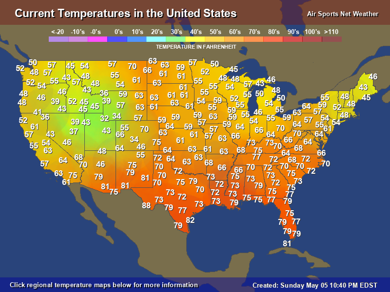
It is currently only in the 50s in S GA and in N FL, as noted in Phil's map above, with sunny skies. It isn't too often to see that in late Oct in the afternoon! Looking forward to today's walk!
Upper 30s tonight much of S GA/N FL, which is almost as cold as O'Hare is this morning! Talk about direct transport of cold air!
 
Last edited:
Not a good sign for winter as per others. Snow near Halloween.
Otherwise, congratulations! That truly is a rarity in the ATL area this early. Wow! And the cold, itself, is certainly impressive. Like night and day vs this time in 2016!
It is currently only in the 50s in S GA and in N FL, as noted in Phil's map above, with sunny skies. It isn't too often to see that in late Oct!
Fuji blue sky with awesome midday shadows due to the sun angle. Paradise.
But, yes, Larry, snow and cold in October tends to give me a bit of concern. Admittedly, we can have a cold spell in October and have a good winter, but a lifetime of observations causes me some genuine consternation in the general scheme of things. Just one man's thoughts, though ... Others probably differ, and that's cool ....
But regardless - on my way to Bivens to enjoy a stiff NW wind, blue skies, a mid-afternoon temp below 60, and some hot sake ... :cool:
 
Last edited:
Back
Top