Those tornadoes out ahead of the QLCS are always very unpredictable. That main line is looking nasty for me in Baton Rouge.
-
Hello, please take a minute to check out our awesome content, contributed by the wonderful members of our community. We hope you'll add your own thoughts and opinions by making a free account!
You are using an out of date browser. It may not display this or other websites correctly.
You should upgrade or use an alternative browser.
You should upgrade or use an alternative browser.
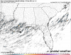
Severe October 27-29 Severe Potential
- Thread starter SD
- Start date
Webberweather53
Meteorologist
The EPS really wants to do this all over again in 2 weeks.

Z
Zander98al
Guest
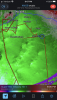
Tight rotation 
Z
Zander98al
Guest
Z
Zander98al
Guest
TOG 

Z
Zander98al
Guest
Instability is already pushing north through Baldwin and mobile county, I think the push northward is a bit ahead of schedule
Z
Zander98al
Guest
Tornado just touched down in a city in MS

I’ll tell you what, that surf is crazy as is the constant wind. This is really gonna be the strongest storms I've ever been on the gulf for.
Z
Zander98al
Guest
I was going to go down and walk on the beach and look. But my wife is upset with me for some reason. Which I don't understand. So she's out here laying on a beach recliner with a bed cover ?. Best I can do is watch from the balcony lolI’ll tell you what, that surf is crazy as is the constant wind. This is really gonna be the strongest storms I've ever been on the gulf for.
I was going to go down and walk on the beach and look. But my wife is upset with me for some reason. Which I don't understand. So she's out here laying on a beach recliner with a bed cover ?. Best I can do is watch from the balcony lol
Shoot man. You need to grab a flashlight and go for a walk on the beach with her and quit thinking about the weather. Hahah
Z
Zander98al
Guest
I told her we can go do that. But she was like no I want to go out driving if anything. ? Sometimes I don't understand. I've given her a bunch of attention today too so idkShoot man. You need to grab a flashlight and go for a walk on the beach with her and quit thinking about the weather. Hahah
Z
Zander98al
Guest
Anyways though. I can start to see flashes of lighting from the qclsShoot man. You need to grab a flashlight and go for a walk on the beach with her and quit thinking about the weather. Hahah
I told her we can go do that. But she was like no I want to go out driving if anything. ? Sometimes I don't understand. I've given her a bunch of attention today too so idk
Something men have been trying to do for thousands of years and likewise the other way around. Haha
Z
Zander98al
Guest
Yeah I've been watching that one. I think that's the one I keep seeing lighting flashes from. Actually has a decent updraft for a small cell like itselfTrying to get going.
Z
Zander98al
Guest
They might pop a tornado warning on it soon. The structure is improving along with the couplet. Fairly decent rotation right now.
Z
Zander98al
Guest
The cell southeast of the decent rotating one is spinning up. Also lighting is getting more aggresive
Let’s see what it brings.
* Until 945 PM CDT.
* At 812 PM CDT, strong thunderstorms capable of producing a few
waterspouts and strong wind gusts were located along a line
extending from near Cat Island to 25 nm southeast of Chandeleur
Sound to 51 nm south of Louisiana Offshore Oil Port, moving
northeast at 45 knots.
HAZARD...Waterspouts and wind gusts 34 knots or greater.
They might pop a tornado warning on it soon. The structure is improving along with the couplet. Fairly decent rotation right now.
Definitely getting very close for a TW.
Z
Zander98al
Guest
I think it just went through a merger with another cell lol.Definitely getting very close for a TW.
Z
Zander98al
Guest
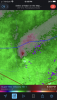
Definitely getting better defined inflow and outflow 

Definitely getting better defined inflow and outflow View attachment 93859View attachment 93860
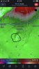
Rotation on both cells strengthening from the NO radar.
Attachments
Z
Zander98al
Guest
Heard the first thunder lol. Lightening is picking up a good bit. Probably means the updraft is getting stronger
Z
Zander98al
Guest
It's getting that hook echo ???
Z
Zander98al
Guest
Very nice looking supercell 
Z
Zander98al
Guest
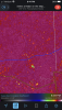
Might produce any second. Watching for the lowered cloud base.
Might produce any second. Watching for the lowered cloud base.View attachment 93863
Sure could, TW gotta be coming soon.
Attachments
Z
Zander98al
Guest
Cc being picked up. Something downSure could, TW gotta be coming soon.
Z
Zander98al
Guest
SawCrud.
Saw a drop in the clouds. I think with the southeast stormCrud.
Z
Zander98al
Guest
Still not tornado warning. SupringlySaw
Saw a drop in the clouds. I think with the southeast storm
Still not tornado warning. Supringly
Yeah, I’m no expert but that looks like a pretty clear TDS.
Z
Zander98al
Guest
That southeast one has a lot to work withYeah, I’m no expert but that looks like a pretty clear TDS.
Z
Zander98al
Guest
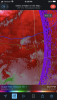
BWER with the southeast one. 

Z
Zander98al
Guest
Don't like the look of this one... 
B
Brick Tamland
Guest
November tornadoes in NC have a pretty bad history.
Z
Zander98al
Guest
Tornado warning issued
Z
Zander98al
Guest
Bigggg BWER. Is this thing about to go boom?