Maybe this is the effect of the STRAT warming we had a month or so back ..
-
Hello, please take a minute to check out our awesome content, contributed by the wonderful members of our community. We hope you'll add your own thoughts and opinions by making a free account!
You are using an out of date browser. It may not display this or other websites correctly.
You should upgrade or use an alternative browser.
You should upgrade or use an alternative browser.
Pattern Novemburrr
- Thread starter SD
- Start date
Yeah that’s a pretty good dip thereIf this cold comes to fruition we have to continue naming our threads without the boring titles .. I mean Novemburrrr would clearly live up to its name

GEFS got much colder as well .. it’s looking like a cave to the euro … we’re also far enough out to where there could still be location placement different in the coming days and all this will be crucial to our weatherYeah that’s a pretty good dip thereView attachment 95104
This is why you don’t trust anything even around 240 hours 
SimeonNC
Member

Oh.

SimeonNC
Member

?

Miller B setup with not enough cold air.
240 hours out with that look .. let’s give her time to cook in the ovenMiller B setup with not enough cold air.
Three runs later vs the above, the 0Z EPS remains an almost identical thing of absolute beauty for cold lovers for the same time:

The three main ensemble means have near wall to wall cold in the SE 11/22-3 through 12/1! Get your parkas ready!
The classic triple wave of cold for the E US, Europe, and China is being progged.
The classic triple wave of cold for the E US, Europe, and China is being progged.
Last edited:
Shaggy
Member
The three main ensemble means have near wall to wall cold in the SE 11/22-3 through 12/1! Get your parkas ready!
The classic triple wave of cold for the E US, Europe, and China is being progged.
I'd love to get another event like Dec 3rd 2000 out of this cold look. Won't happen but it's good to see some cold again before christmas.
Downeastnc
Member
32/32 so first official freezing temp at PGV this fall/winter season....
Webberweather53
Meteorologist
This is why you don’t trust anything even around 240 hours View attachment 95105
240 hours out with that look .. let’s give her time to cook in the oven
?
What’s your point? I’m saying you can’t trust anything 240 hours out in both statements lol
Avalanche
Member
Of course we can't. Models fluctuate like ridges and troughs. I hope for it, though I am not a weenie. I don't expect to have a concrete outcome this far out.What’s your point? I’m saying you can’t trust anything 240 hours out in both statements lol
Webberweather53
Meteorologist
The big 3 operational runs all have some kind of cut off low over the Desert SW around day 10 along with a SE ridge. Wonder how long it’ll take for me to screw this up


Avalanche
Member
Its only fitting Flagstaff or Scottsdale beat me to it.
Operationals vs ensembles ? oh bless the Gfs’s heart


Webberweather53
Meteorologist
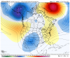
Notice you didn’t show the GFS’s own ensemble, the GEFS, which looks the same as the opOperationals vs ensembles ? oh bless the Gfs’s heartView attachment 95114View attachment 95115View attachment 95116

Todays Model fantasy Image of the day winner is the CFS, with Euro coming in 2cnd place. No model can cough em up like the CFS. These are for next Tuesday


Nearly mega frost criteria this morning and 28
Hi All I'm Back for another season of wishing our lives away 10 Days at a time...
bigstick10
Member
LOL, I know, and then at the end to have warm air win out.Hi All I'm Back for another season of wishing our lives away 10 Days at a time...

NBAcentel
Member

Eps looked good to me
Only 31.1 here, patch of clouds rolled through last night and capped the heat release, in fact warmed to 36 by sunrise.Nearly mega frost criteria this morning and 28
I see we're doing the "find the map of what I want to happen the most and post it" dance this morning.
NBAcentel
Member
?

Cary_Snow95
Member
My biggest question still is how this pattern progresses into December. Gut tells me the NAO breaks down by then but who knows
Webberweather53
Meteorologist
Within the EPS suite there are both cut-offs and eastern troughs, but the idea (via @NickyBGuarantee) that the GFS was way out in left field and not supported by ensembles is nonsense. Have to admit, having the Canadian ensemble (GEPS) show the most favorable look during this time for the SE US isn't exactly heartwarming because between the 3 ensembles (EPS, GEFS, & GEPS) it's usually most likely to be wrong. At this point, it hasn't rained here in nearly 2 months, cold rain for me would be a win.

So a pretty typical cold season weather forum experience lolI see we're doing the "find the map of what I want to happen the most and post it" dance this morning.
Yeah, seems to be the case these days and the norm I guess. Post your favorite map and call others out, always makes for a fun time (which I've been told I need more weather forum fun in my life so sure, why not)So a pretty typical cold season weather forum experience lol
I think one thing is for sure, models are still all over the place in the long term and strong high latitude blocking with a pac that doesn't want to play nice, can do that. That's some strong blocking though and I'd like to think that will eventually bode well for many in the SE, if it can hold on long enough.
NBAcentel
Member
Feels like the same battle as last year, averaging out the next couple of weeks, avg-slightly bn avg is the way to goI think one thing is for sure, models are still all over the place in the long term and strong high latitude blocking with a pac that doesn't want to play nice, can do that. That's some strong blocking though and I'd like to think that will eventually bode well for many in the SE, if it can hold on long enough.
LickWx
Member
I take it one day at a time . Models I don’t pay attention to a whole lot. All I know is it’s been sunny and the cold days aren’t so bad either . Starting to progress to a wintry look with the bare trees . My favorite in winter though is the vast pine forests on the backdrop of a blue sky day in winter . I’ve also been stargazing a lot , something more difficult to do in summer . Saw 5 shooting stars Saturday night ! I definitely will go to the beach next month for a day, if not camp. Beach in winter is nice . I’m a simple man.
Good point. As we head into winter, strong blocking, should it materialize, is a good sign. However (and there always seems to be a however), the Pacific has been in a largely unfavorable state for sustained cold air delivery into the SE. Until we see actual evidence that that is changing, I'm inclined to not trust long duration cold in the east.I think one thing is for sure, models are still all over the place in the long term and strong high latitude blocking with a pac that doesn't want to play nice, can do that. That's some strong blocking though and I'd like to think that will eventually bode well for many in the SE, if it can hold on long enough.
That said, a big Greenland block of enough magnitude will suppress the flow enough to keep the anomalous warmth at bay, even if some 500 mb maps get posted showing yellow or orange colors over the SE.
Anyway, evidence of strong blocking now is good. Until the Pacific can prove its case, then it would be prudent to look at sustained cold (not in and out cold shots) with the side eye.
At the very least, it feels like fall now. And hints of winter are definitely in the air.
Last edited:
If that blocking can hold like it did a year ago. I feel really good about our chances as we go through December. There is at least some decent cold air building up in NW Canada that wasn’t there last year. I would just like to see our northern states start to build some snow coverI think one thing is for sure, models are still all over the place in the long term and strong high latitude blocking with a pac that doesn't want to play nice, can do that. That's some strong blocking though and I'd like to think that will eventually bode well for many in the SE, if it can hold on long enough.
Been watching the NAO forecasts and you certainly have to like the trend compared to last week. Real opportunity to go very negative
November 9th

Today
.gif")
November 9th
Today