• Hello, please take a minute to check out our awesome content, contributed by the wonderful members of our community. We hope you'll add your own thoughts and opinions by making a free account!

Pattern Nippy November

GEFSSE_prec_ptypens_090.png
 
Maybe because the mountains are in the viewing area. Him saying massive is weird.

It also gets eyes on the tv next week or maybe he sees something we don’t, with his experience I’m guessing he might have seen a system like this before and wants to get in front of it. JUST IN CASE.


Sent from my iPhone using Tapatalk
 
It also gets eyes on the tv next week or maybe he sees something we don’t, with his experience I’m guessing he might have seen a system like this before and wants to get in front of it. JUST IN CASE.


Sent from my iPhone using Tapatalk
I think this is his reasoning imo
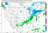
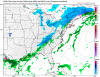
 
Not liking how the 12k nam is looking for Tuesday. It doesn’t bring the cold air down for snow as fast as the gfs. This may be the more accurate scenario.
 

Attachments

  • namconus_ref_frzn_us_fh81-84.gif
    namconus_ref_frzn_us_fh81-84.gif
    369 KB · Views: 64
Not liking how the 12k nam is looking for Tuesday. It doesn’t bring the cold air down for snow as fast as the gfs. This may be the more accurate scenario.
Cause it's the long range Nam
 
Gefs only seems to be getting better for that second wave associated with that Shortwave near Mexico, speeds up just a tiny tiny bit more, and that NE trof digs a bit more, still probably lots of members with cold rain and it appears barely any snow, but it’s getting closer. Climo don’t help except for typical CAD areas around I-40/western NC F29A1799-90AE-49EB-B31B-BE07328233FF.gifD5F6E85F-9102-4B7C-B24A-104CD8E77413.gif
 
Got to love long range NAM... out of nowhere looking juicer and more timing friendly to tease you to look for trends
 

Attachments

  • namconus_ref_frzn_eus_52.png
    namconus_ref_frzn_eus_52.png
    214.1 KB · Views: 73
Tuesday will be a good snow for mountains probably 3-5 inches nc/tn border


Sent from my iPhone using Tapatalk
 
Got to love long range NAM... out of nowhere looking juicer and more timing friendly to tease you to look for trends

Ah yes the good old way too amped long range NAM. It’s pulled us in many times only to trend drier than dryer lint in a 20 year old drying machine.
 
Careful with the NAM maps of simulated reflectivity. They can be quite deceptive. Doesn't mean any of that is reaching the ground, etc.
 
Hi ladies and gentlemen. I have one question and hopefully someone will answer. The AAM has been negative, which coincides with niña esque type pattern. What is needed to flip the AAM to neutal or even positive, if that will increase chances for colder weather moving forward? Thanks in advance.
 
Back
Top