-
Hello, please take a minute to check out our awesome content, contributed by the wonderful members of our community. We hope you'll add your own thoughts and opinions by making a free account!
You are using an out of date browser. It may not display this or other websites correctly.
You should upgrade or use an alternative browser.
You should upgrade or use an alternative browser.
Severe New Year's Week Severe Threat(s)
- Thread starter RBR71
- Start date

Shaggy
Member
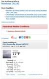
70/67 on my PWS, so definitely juicy out@BHS1975 my personal temp device matches up with the obs station at the airport and I am maybe 6 miles SW
Bout to get spicy around here.
Sent from my iPhone using Tapatalk
Well, that was a bunch of nothing here. Small gust for 30 sec or so and it’s over. Power went out, but around here it goes out if you sneeze too hard.
Sent from my iPhone using Tapatalk
Sun is out here. Any chance we get a second round this evening?
NoSnowATL
Member
noSun is out here. Any chance we get a second round this evening?
Shaggy
Member
I am a mile or so away from the aiport and we were 4 or 5 miles south of the storm and still gusted to 36 as it passed by. estimated winds in the storm were up there so wouldn't be surprised to see some damage reports
Shaggy
Member
Had a 30-40 foot light pole snap off at the base at work as the storm passed north of us