Not so much wetter yet; slower by a bit, sure. Should not be a fail for those to my West. Lets hope this helps GA/Carolinas. ;/
-
Hello, please take a minute to check out our awesome content, contributed by the wonderful members of our community. We hope you'll add your own thoughts and opinions by making a free account!
You are using an out of date browser. It may not display this or other websites correctly.
You should upgrade or use an alternative browser.
You should upgrade or use an alternative browser.
Wintry More SE Snow ? (1/16-1/18)
- Thread starter GeorgiaGirl
- Start date
Stormlover
Member
by 9am already an inch in the shoals area(nw ala),about double the 18Z
Webberweather53
Meteorologist
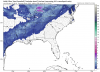
This definitely has a shot to be a juicier system than some NWP models have been advertising especially closer to the Atlantic Coast in the SE US. Very impressive mid-level southwesterlies right off the Gulf of Mexico into the Carolinas, GA, & VA without much appreciable convection on the Gulf Coast to impede moisture transport.... Woof.

Brett
Member
love the looks of That!!This definitely has a shot to be a juicier system than some NWP models have been advertising especially closer to the Atlantic Coast in the SE US. Very impressive mid-level southwesterlies right off the Gulf of Mexico into the Carolinas, GA, & VA without much appreciable convection on the Gulf Coast to impede moisture transport.... Woof.
View attachment 2894
This definitely has a shot to be a juicier system than some NWP models have been advertising especially closer to the Atlantic Coast in the SE US. Very impressive mid-level southwesterlies right off the Gulf of Mexico into the Carolinas, GA, & VA without much appreciable convection on the Gulf Coast to impede moisture transport.... Woof.
View attachment 2894
This albeit slightly slower situation, and a bit more digging, can help the SW flow really start to work it's way into and increase precipitation chances the longer it takes, correct?
Webberweather53
Meteorologist
This albeit slightly slower situation, and a bit more digging, can help the SW flow really start to work it's way into and increase precipitation chances the longer it takes, correct?
Exactly, this is the key element we've been missing since our early December event but we have it here...
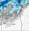
00Z NAM is a great start for Central and Northern Alabama for tonights runs.
Ruh roh; some energy trying to creep into the trough from the West htis run vs 18z. Likely won't amount to much this go; but good to watch.
JLL1973
Member
Nam gave me 2 inches not as juicy as 18z but I'll still take it
Brett
Member
What’s that precip that’s offshore of NC moving west?
GeorgiaGirl
Member
What’s that precip that’s offshore of NC moving west?
Think it's going to help redevelopment if the band dies as it has been doing.
(then again if there's a dual jet we shouldn't have the band dying)
Stormlover
Member
better for central ala for sure
Webberweather53
Meteorologist
Yeah this is trending towards a classic overrunning event for most on the board granted it probably will be more impressive further eastRuh roh; some energy trying to creep into the trough from the West htis run vs 18z.
Band looks to stay together longer this run for our state.
Yeah this is trending towards a classic overrunning event for most on the board granted it probably will be more impressive further east
By 48, there is a piece really breaking off to help us out our way. Again, not something crazy, but any little bit helps here.
accu35
Member
I notice with each run, theres moisture hanging longer towards south central Bama
accu35
Member

Wait till the end of the run and everyone has posted maps, comments, etc before you consider mby questions please.... most likely they will get answered. Thanks.....
GeorgiaGirl
Member
Might we be seeing what Chris has said a few times in that the models play catch up with a gulf tap/dual jet on how much moisture we should see?
That’s the rpm model. It has been on the drier side with the gfs on this event.And with this forecast there will be no milk or bread to be found. people lose their minds...just got home from Walmart and the bread is already almost gone
Band falls completely apart by hour 54. Lets see if we can get it back. Some in NC left over.
Snowflowxxl
Member
Still dry for ATL even with the positive trend
accu35
Member

jaymackd3
Member
Yeah I guess it’s the conservative news channel model...it always looked drier doesn’t it?That’s the rpm model. It has been on the drier side with the gfs on this event.
GeorgiaGirl
Member
There's the dual jet again with the band falling apart and dewpoints still being okay in Georgia/the Carolinas. Granted North Carolina will likely be fine though.
....what?
....what?
Much better
Yep, 1/2 inch for majority of Central Alabama, but with temps in the 22-27 degree range. I’d easily expect accumulations to be closer to 1 inch. QPF was right at .05 for most.
Attachments
Stormlover
Member
RollTide18
Member
Big southward shift of precip on 0z compared to 18z


Webberweather53
Meteorologist
There will probably be appreciable precipitation east of the mountains in NC in a setup like this, the flow is southwesterly for 24-30 hours straight @ 700 hPa (& strongly at that) before the longwave even reaches the NC/TN border
Stormlover
Member

Well

Sent from my SM-G955U using Tapatalk

Sent from my SM-G955U using Tapatalk
LovingGulfLows
Member
- Joined
- Jan 5, 2017
- Messages
- 1,499
- Reaction score
- 4,100
Why is the moisture transport being cut off before it hits the Atlanta area? I'm looking at RH field maps and 500 mb heights and can't understand it. There's still a decent SW flow at 54.
Where's a good spot to be under that streak?Well
Sent from my SM-G955U using Tapatalk
Bahaha that map shane just posted should be katie barred the door precipitation for GA & Carolinas at least.
\
\
gawxnative
Member
Same question..lolWhy is the moisture transport being cut off before it hits the Atlanta area? I'm looking at RH field maps and 500 mb heights and can't understand it. There's still a decent SW flow at 54.
RollTide18
Member
Why is the moisture transport being cut off before it hits the Atlanta area? I'm looking at RH field maps and 500 mb heights and can't understand it. There's still a decent SW flow at 54.
Yeah I'm still confused on why it's going poof in three hours.
packfan98
Moderator
Less precip east of the mountains this run. Not sure why it’s not beefing it up with the look aloft.
GeorgiaGirl
Member
Why is the moisture transport being cut off before it hits the Atlanta area? I'm looking at RH field maps and 500 mb heights and can't understand it. There's still a decent SW flow at 54.
We all don't. Everything points to that band shouldn't go bye bye but it does. Dewpoints are ok (unlike earlier this month), there's a dual jet look with a gulf tap, and the SW flow.
I guess we are going to get the whole "no forcing" argument here; but that flow and jet streak. nah man.
Brett
Member
It just dies as it comes into eastern va and NC I don’t get it