• Hello, please take a minute to check out our awesome content, contributed by the wonderful members of our community. We hope you'll add your own thoughts and opinions by making a free account!

Wintry More SE Snow ? (1/16-1/18)

Smoke show weather babe Jennifer Valdez made no mention of the WWA on CBS 46. Showed the RPM. Just goes to show that no one has any idea on what’s going to happen with regard to how much redevelops, if any. She loves to say “flurries”.


Sent from my iPad using Tapatalk
mmm, flurries....
hqdefault.jpg
 
Just looked at miss dot cam ...Oxford Miss roads already covered. It looks loke according to radar it is on the front end of the snow, much more to come. also snowing in Vicksburg in SW Miss.
 
Ok some things to watch for on models. Yes I know it's almkst good time, but you still have to watch for trends.
1. MOST IMPORTANT is where and when ( how fast) does the jet streak develope. (that will help many of us keep that band alive, for 1, but IMHO is VITAL for us in GA and the Carolinas)
2. Does the upper energy (500mb) slow down a bit more and close off, or at least tilt more
3. Finally... Watch to see where models keep placing the best quality moisture/QPF
 
Looks like the 6z ICON backed off quite a bit from earlier runs.
True but that pretty much brings it in line with all other guidance and it's .5-.75 amounts were probably way overdone up here, it's still .2-.4 with a bulls-eye over central NC up into south central Va.... solid 2-4" event with maybe a localized jackpot of 5-6
 
Spann sounding the horn this morning in his weather extreme video that once the snow starts falling...you've got around 30-45 min before it starts flash freezing on the roadways. He's expecting a pretty significant impact on the roadways apparently.
 
For NC most models continue to increase QPF totals ranging .3 - .5, as noted on here and Rah NWS stating it as well now possible 20:1 ratios... should quickly pile up.

Sent from my SM-G920V using Tapatalk

What about temps?


Sent from my iPhone using Tapatalk
 
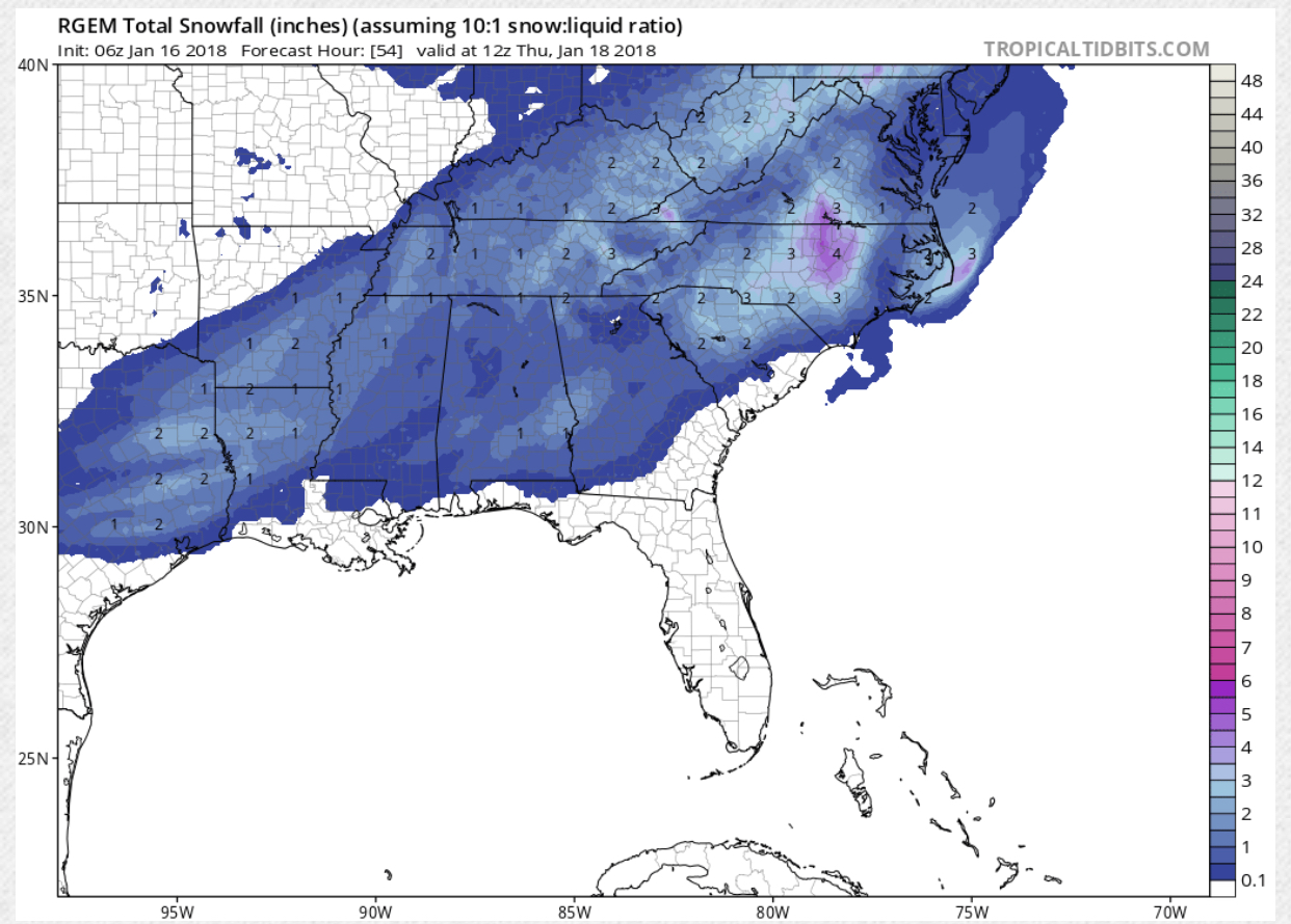
RGEM looks great

FB4BB014-3609-497A-B0D4-99149B4E6AA3.jpeg.0193d588825fc0c0003cbb5d8209cd07.jpeg
Has a small jackpot area just west of Durham up through Roxboro looks like of 5".... again I'm looking at QPF totals due to the possible insane 20:1 ratios, although the kuchera maps on pivotal should be closer to accurate but they could be underdone IF the total qpf is correct.
snku_acc.us_ma.png
 
You would think that the largest TV market in the SE would have a better realistic approach to this, This is where Atlanta gets in trouble and it is the producers that are to blame, they tell them not to alarm or panic, lol, the public, then they get egg on their face later,,,
You would really think they will learn their lesson but they don't.
 
What about temps?


Sent from my iPhone using Tapatalk
Temps do not appear to be an issue, the ICON still shows some issues at onset but it has a warm bias (so I've heard) and even Rah NWS not mentioning much about any mix to begin with, if so it will be a rapid change over to all sn and then quickly go to high ratios
 
Back
Top