Stormsfury
Member
Appreciate this map! Not only was this quite a memorable storm... It also set the stage for the coldest March low in KCHS history. 15.

No problem! I’m honestly surprised it didn’t occur in 1960...Appreciate this map! Not only was this quite a memorable storm... It also set the stage for the coldest March low in KCHS history. 15.
.png")


Wow these soundings are close to wet snow View attachment 36777View attachment 36778View attachment 36779


That was a hell of a storm to put measurable snow down over the entire states of SC/NC....

@Webberweather53 even if it was to happen a few weeks ago, we here in the South would of still have a issue with something. Fails in Dec, Jan, Feb!Hmmm...some flakes across the piedmont tomorrow night...maybe. It's to bad this wasn't a few weeks ago.
View attachment 36790View attachment 36791


Canadian went ham at 00z..this would cripple the TN/NC borderView attachment 36795
It’ll make it’s own cold air ?
God that’s a monster
View attachment 36796

Northern Wilkes onset ice?A few weeks earlier and some snow pack to the north this might've been fun.... but if's and but's were candy and nuts
View attachment 36797

.gif")

.gif")
.png")
.gif")
Currently getting whiffed. Moderate/heavy rain 6 miles to my south moving E/NEGood luck with this gradientView attachment 36808


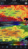
Bright banding on going.Rain is absolutely relentless. Real nice band of rain over me right now. Getting some huge rain drops with this as well.View attachment 36818
Just pretend it's deep in January, and your rain/snow line is 40 miles to your north still..Rain is absolutely relentless. Real nice band of rain over me right now. Getting some huge rain drops with this as well.View attachment 36818
")


I forgot how much we had here in JAN, but Feb we had over a foot and now 3 inches to start the month here. I would believe over 20 here for the year.KATL: wettest Jan 1 through Mar 4 on record (back to 1879) with over 20" or about double their normal! Their average date to reach 20" is not til
May!