Tornadocane
Member
Per NWS: THE FLASH FLOOD WARNING REMAINS IN EFFECT UNTIL 400 PM EDT FOR NORTHERN BROWARD AND SOUTHEASTERN PALM BEACH COUNTIES... At 221 PM EDT, Doppler radar indicated thunderstorms producing heavy rain across the warned area. 5 to 8 inches of rain have fallen. https://wsvn.com/weather-alerts/
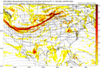
As I and Miami NWS said the other day, the airmass coming up was going to be wetter than indicated on models, and this will drive up into the Apps and Ohio Valley to enhance the rainfall totals along the incoming frontal system. We broke a Maximum Low Temperature of 77 yesterday with a Low of 79, and some places were able to hold at 82 before heavy T-Storms at 2-3AM last night prevented multiple monthly record-breaking event. Temperatures still made it near 89 degrees despite cloud cover and rainfall.
As I and Miami NWS said the other day, the airmass coming up was going to be wetter than indicated on models, and this will drive up into the Apps and Ohio Valley to enhance the rainfall totals along the incoming frontal system. We broke a Maximum Low Temperature of 77 yesterday with a Low of 79, and some places were able to hold at 82 before heavy T-Storms at 2-3AM last night prevented multiple monthly record-breaking event. Temperatures still made it near 89 degrees despite cloud cover and rainfall.
Last edited: