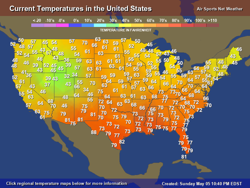
• Hello, please take a minute to check out our awesome content, contributed by the wonderful members of our community. We hope you'll add your own thoughts and opinions by making a free account!

Pattern May Thread

I love spring and hate when we get jipped out of it . Out of all seasons it seems to be the easiest to miss out on because of its instability .
Huh? I mean we've been having Spring weather since Feb. Seems like winter was the one we got jipped out of ( just the exception of one single snow for us anyway)
 
I really expected warmer yesterday, but the dewpoint shot up sometime late last night. It has only hit 87F here so far today, and only .41" of rain in the past 30+ days. This has been by far the driest stretch since being back in Georgia for the past five years. These dry periods through spring and fall are normal, however, its just the befuddlement of the past three large systems dissipating to the bewilderment of everyone right when they get here. I have my reservations about the upcoming wet pattern.

View attachment 118591
I got lucky and picked up .75” a few nights ago but it’s been so dry you could barely notice. We did manage to hit 90.1 up here yesterday after a low of 62. I think we had one 90 previously.
 
Heat burst event captured at PGV last night with the storms that died right as they reached the county....

20
04:55​
N 310.00
Fair​
CLR686178%NANA29.85NA
20
04:35​
Calm10.00
Fair​
CLR705969%NANA29.84NA
20
04:15​
SW 310.00
Fair​
CLR725965%NANA29.83NA
20
03:55​
S 610.00
Fair​
CLR775751%NA7929.82NA
20
03:35​
SW 610.00
Fair​
CLR815237%NA8029.81NA
20
03:15​
N 13 G 2510.00
Fair​
CLR864827%NA8329.80NA
20
02:55​
NW 910.00
Light Rain​
SCT025 SCT100 SCT120775751%NA7929.80NA0.05
20
02:35​
SW 57.00
Light Rain​
SCT080 SCT090 BKN120736369%NANA29.84NA0.05
20
02:15​
W 12 G 2410.00
Mostly Cloudy​
SCT070 BKN090796665%NA8129.90NA
20
01:55​
SW 810.00
Fair​
CLR797384%NA8329.85NA
20
01:35​
SW 710.00
Fair​
CLR777389%NA7829.85NA
20
01:15​
S 310.00
Fair​
CLR757394%NANA29.85NA
20
00:55​
Calm10.00
Fair​
CLR757289%NANA29.85NA

 
Last edited:
It's actually hard to dislike the next 7 days with regards to rain chances. There are a few ways we could eat a big oof burger but the pattern is pretty active so staying completely dry during the period seems unlikely
Oh you’ll get all the rain you want next week. I’ve been waiting for four weeks now to get concrete poured around my pool. They’re supposed to come and do paver coping around the pool next week. Then I can get the concrete poured sometime the following week. So I guarantee you it will rain every day next week. ?
 
I can live with this , as we roll into June! Looks like I lost the frost threat!?33094423-3AAC-4F85-8FF6-500095B34845.png
 
Pretty big spread in temps and weather from West to East. We're mid summer and part of the Rockies and Plains are in winter, with a snow storm from CO to the Dakotas and N Minnesota!

current-temperature.png


surface-weather-map.png
 
Last edited by a moderator:
Models are speeding up the timing of the frontal paasage again tomorrow, which might put our 15th day to tie the longest May 90*F streak.
 
277A788F-3152-4B67-9EE7-05BA538AEA09.png3F17AFBA-D6C4-40A3-9C23-4B367C83B46D.png51A69364-2C74-4363-B9D8-3E92C97D53BC.png
...Southeast into the Carolinas and Southern Virginia...
Cool mid-level temperatures and daytime heating should support
moderate to strong instability across much of the Southeast on
Saturday. Even though winds aloft are forecast to remain generally
weak, pulse-like convection and perhaps a few multicells may be
capable of producing isolated hail and damaging winds through the
afternoon and early evening.
 
NWS Miami needs have finally issued a flood flash warning for storms redeveloping and training through Eastern Broward and SE West Palm Beach County. Rainfall Rates as high as 4-10 inches per hour have dropped copious amounts of rain around Ft. Lauderdale and Boca Raton, and 4-6 inches of rain have already fallen around the warned areas. After driving through this area last hour, it is my opinion that Miami NWS issue a Flood Emergency given the radar trends indicating 4-8" radar returns. https://www.weather.gov/mfl/

KAMX_loop.gif
 
Back
Top