I had a feeling they were being too bullish for the coastal areas… though with some of the band that’s coming in, there’s gonna be some spots that add totals quickly… depending where bands train over areas.They said on TWC earlier that there forecasts of 3-6” of rain near the coast, was gonna bust hard! Wilmington was up to only 1/2 an inch at 11 AM this morning
-
Hello, please take a minute to check out our awesome content, contributed by the wonderful members of our community. We hope you'll add your own thoughts and opinions by making a free account!
You are using an out of date browser. It may not display this or other websites correctly.
You should upgrade or use an alternative browser.
You should upgrade or use an alternative browser.
Pattern May Discussion
- Thread starter RBR71
- Start date
Really looks impressive on satellite
vsublazer
Member
This blows…not really. Weather is going to do what weather does but the wind can go. For this not to be a tropical system the wind hasn’t let up since we got in yesterday in North Myrtle Beach. It’s been a constant 18-22 mph winds. The rain has been so bad. The lifeguards have been patrolling the beaches nonstop where we are at because there is sure to be someone not so bright going out in the ocean. Hopefully, tomorrow will be better.
Certainly may see a change in character of the rain tomorrow as we get some elevated cape on top of the wedge layer
View attachment 052723.mp4
18z HRRR reflectivty
View attachment 052723.mp4
View attachment 052723.mp4
18z HRRR reflectivty
View attachment 052723.mp4
This weather…. Oh my…Let’s keep it rolling.
Edit: Thank y’all in NC for taking the brunt of it yet giving us cool NE flow.
Edit: Thank y’all in NC for taking the brunt of it yet giving us cool NE flow.
HugeSnowStick
Member
This is truly amazing...
It really is. It won’t make the news, but this event is sooooo rare. Memorial Days high is 77 degrees with pure sunshine! What a weekend.
HugeSnowStick
Member
It is definitely making news over this way... You're a bit warmer, The wind even in Atlanta has been 35 gusts today..It really is. It won’t make the news, but this event is sooooo rare. Memorial Days high is 77 degrees with pure sunshine! What a weekend.
Yeah, it’s been just plain nice here with a cool 10mph NE breeze.It is definitely making news over this way... You're a bit warmer, The wind even in Atlanta has been 35 gusts today..
LickWx
Member
We are not happy… weather sucks butt … Columbia was in the low 50s all day …This weather…. Oh my…Let’s keep it rolling.
Edit: Thank y’all in NC for taking the brunt of it yet giving us cool NE flow.
Thanks for thinking about us tho
Never gonna make it! ?Staying east it looks like. They need to cut precip amounts by 75% or more west of I-77. Way too much dry air to overcome.

We are not happy… weather sucks butt … Columbia was in the low 50s all day …
Thanks for thinking about us tho
You are welcome. I thought about saying “weather is wonderful here, Stinks to be y’all” or “The rain couldn’t happen to better people” but I’m a good person.
Brent
Member
It really is. It won’t make the news, but this event is sooooo rare. Memorial Days high is 77 degrees with pure sunshine! What a weekend.
Seriously I can't believe the one time I come back to Alabama on Memorial Day weekend of all times I get perfect weather the entire 4 days. Today was just the icing on the cake and the perfect way to wrap it up

J1C1111
Member
It's always nice setting record low highs on Memorial day weekend and to be just a few days out from June is even better. Today was colder than Thanksgiving was around here.
Brent
Member
It's always nice setting record low highs on Memorial day weekend and to be just a few days out from June is even better. Today was colder than Thanksgiving was around here.
There are colder spots around here in East Alabama that may be in the 40s by morning. Probably nearly unheard of this late. There's been many years they are already in full on summer by now
iGRXY
Member
I was a little worried about the coverage earlier but this thing is backfilling nicely and it’s been a co start rain here since 2 this afternoon.
Nomanslandva
Member
I noticed the neighborhood pool did not open yesterday. To me, I'll take what we had yesterday, mainly nice not having to burn $ on AC with just a few sprinkles. If you wanted to be in the pool or lake, you would have a different take on it. the rest of the weekend looks pretty bad though if the rain eventually gets here. 90 Sat is going to be rude!
Shaggy
Member
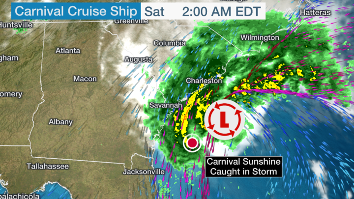
Bout to make "landfall". Imagine if this was a cat 3 what a landfall it would have been.


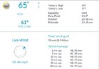
Up to 66 might make 70 today
Considering I have a house on Oak Island, I’m very grateful this isn’t a cat 3… one coming in right there at that angle would probably put most of Oak Island under waterBout to make "landfall". Imagine if this was a cat 3 what a landfall it would have been.
It’s absolutely amazing to me how horrible TWC’s radar is. It has barely any precip showing over me since the initial band came through yesterday, yet most of that time there has been a moderate rain still falling
severestorm
Member
It's IBM lol Looks like they are selling soon though.It’s absolutely amazing to me how horrible TWC’s radar is. It has barely any precip showing over me since the initial band came through yesterday, yet most of that time there has been a moderate rain still falling

IBM Considering Sale of Unit that Owns Weather Channel, Weather Underground
(Bloomberg) -- International Business Machines Corp. is considering selling its weather business as the company continues to focus on software and cloud services.Most Read from BloombergWorthless Degrees Are Creating an Unemployable Generation in IndiaApple, Goldman Sachs Debut Savings Account...
The Euro looks like redux in a week. Come on y’all in NC. Y’all can take it on the chin again for our benefit right?
LickWx
Member
Sounds about right, the state of NC subsidizing the slouches of Alabama! Come on Bama do somin for a change you bunch of moochers!The Euro looks like redux in a week. Come on y’all in NC. Y’all can take it on the chin again for our benefit right?
severestorm
Member
wow!
I havent observed a moment since about 11am Saturday morning where it hasnt been atleast light showering drizzling. 48 straight hours and counting. Weve had some heavy rain at times to. Not gonna see the sun today thats for sure over this way
Memorial Day in Alabama, and I had the AC off all day. Probably about as rare as the 12/17 snowstorm.
Brent
Member
wow!
I always figured cruise ships avoided storms like these but I guess not
Just hit 70 .gif")
LickWx
Member
If you’re a good boy today it might just hit 75… or even… 80Just hit 70 View attachment 135331
 … imagine that
Looking like the avg temp for May here will be 5 degrees cooler than last May. Impressive
Brent
Member
10 years since El Reno today and on the flip side this year hardly any bad weather this month. El Reno was just the last in a series the second half of May 2013 here. It was so bad in OKC people drove the wrong way on the interstate
Rip Twistex
Rip Twistex
NoSnowATL
Member
The year that killed Tornado season10 years since El Reno today and on the flip side this year hardly any bad weather this month. El Reno was just the last in a series the second half of May 2013 here. It was so bad in OKC people drove the wrong way on the interstate
Rip Twistex
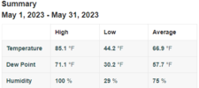
Max 86.5
Min 39.6
Avg 65.8 -3.1
Rain 4.04 +.8 ish
Snow 0
11 highs above 80 9 highs below 70
Min 39.6
Avg 65.8 -3.1
Rain 4.04 +.8 ish
Snow 0
11 highs above 80 9 highs below 70
My man! ?Max 86.5
Min 39.6
Avg 65.8 -3.1
Rain 4.04 +.8 ish
Snow 0
11 highs above 80 9 highs below 70
Max: 89.1
Min: 39.7
Avg: 65.1
Rain: 3.04
Max wind: 30.2
Snow: zilch
Min: 39.7
Avg: 65.1
Rain: 3.04
Max wind: 30.2
Snow: zilch

NoSnowATL
Member
Max: 89.4
Min: 52.2
Rain: 6.02in
Max wind: 48.8mph
Snow: 1.5in
Min: 52.2
Rain: 6.02in
Max wind: 48.8mph
Snow: 1.5in
Did you have a hailstorm that you’re counting as snow?Max: 89.4
Min: 52.2
Rain: 6.02in
Max wind: 48.8mph
Snow: 1.5in