Shaggy
Member
The map was already shared but thanks for clarifying, because the words severe or extreme were not in your post I responded to.It is abnormally dry with moderate drought starting to show up ... this is all after the driest spring we have had in a while .. now we’re starting to see more rain come into play along with next weeks more widespread stuff .. I believe this should get tampered down a bit at the least .. I’m talking about extreme drought or severe drought ... don’t see that becoming widespread at all or even showing upView attachment 84435
Significant severe extreme .. they all have similar meaning to me. CheersThe map was already shared but thanks for clarifying, because the words severe or extreme were not in your post I responded to.


Yep not bad, some decent amounts in places that need it. Of course, there are those pockets that get little to nothing, hopefully those fill in over the coming days3k Looking good tomorrowView attachment 84440

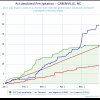
15 straight days without measurable rainfall imby
Yeah there is likely to be a few holes but with the wedge front moving south and the cells moving north or northeast we should get a decent coverage of some rainYep not bad, some decent amounts in places that need it. Of course, there are those pockets that get little to nothing, hopefully those fill in over the coming days
View attachment 84442
Well now if we're not counting .05 then you and I are tied lolNot a competition, but going on 18 today, if you don't include that laughable 5 hundredths of an inch. I don't think that's enough rain to even wet the bottom of the rain guage.
My .12 this week puts me atop the leader boardWell now if we're not counting .05 then you and I are tied lol
Does it show rain with that?I just checked for myself and all the rain is out of the area yet it shows temps that cool?
Does it show rain with that?I just checked for myself and all the rain is out of the area yet it shows temps that cool?

Yeah but clouds alone won’t keep temps at the absolute coldest possible for this time of year ! That takes rain. We shall see but from my experience it’s the rain that keeps it low not the clouds .
It may not be measurable, but it could be misty junk.Yeah but clouds alone won’t keep temps at the absolute coldest possible for this time of year ! That takes rain. We shall see but from my experience it’s the rain that keeps it low not the clouds .
Indeed soundings are ugly. South over North oof RIP pools on SundayIt may not be measurable, but it could be misty junk.
.png")
2 years in a row where we knock on the absolute coldest possible highs for the time of year , same with lows. Insane . Not that crazy though, February 2017 and 2018 both saw multiple 80s and higher even which is the absolute warmest for that time of year .Indeed soundings are ugly. South over North oof RIP pools on Sunday
View attachment 84444
I blame stronger longer lasting PVs2 years in a row where we knock on the absolute coldest possible highs for the time of year , same with lows. Insane . Not that crazy though, February 2017 and 2018 both saw multiple 80s and higher even which is the absolute warmest for that time of year .
Stronger would mean stuck over the Arctic though , longer perhaps .I blame stronger longer lasting PVs
SemanticsStronger would mean stuck over the Arctic though , longer perhaps .
This would be absolutely crazy for sure .. CAD always poking its head out at us ?
Great coverage for sure and next week should help fill in the blanks... will help with creeks and streams thoYep not bad, some decent amounts in places that need it. Of course, there are those pockets that get little to nothing, hopefully those fill in over the coming days
View attachment 84442
Take it to whamby . That’s all. I’ll let the mods take it from hereThe warm weenies already scattering like flies ? I love it
Indeed, that stuff has got to go to whamby going forwardTake it to whamby . That’s all. I’ll let the mods take it from here
Yeah... even in that CAD a couple weeks ago, I was in the upper 40s while it was raining but as soon as the rain stopped it stayed cloudy and the temp still rose pretty quickly to 54-55Yeah but clouds alone won’t keep temps at the absolute coldest possible for this time of year ! That takes rain. We shall see but from my experience it’s the rain that keeps it low not the clouds .

The warm weenies already scattering like flies ? I love it
The last few memorial day weekends have had some sucky weather involvedBecause it's not supposed to be 60 degrees on Memorial Day weekend. I was supposed to River Jam, now I am reconsidering. Hopefully, the wedge won't be as stout as some of the current modeling is suggesting.
The last few memorial day weekends have had some sucky weather involved
As long as there is no rain I think we will be fine . Seems rain clears out before noon so here’s to hoping .Yeah, but I don't think we ever had highs in upper 50's to lower 60's? If we did, I don't recall. I'd be fine with upper 60's to lower 70's.
I doubt it's been that cool but I remember lots of rain outsYeah, but I don't think we ever had highs in upper 50's to lower 60's? If we did, I don't recall. I'd be fine with upper 60's to lower 70's.


Oh manThat’s a weird mid level cap but still gets broken View attachment 84449View attachment 84450
Hrrr has been waffling to, this is the farthest west it has been, nam has been consistentOh man


Wouldn't be surprised to see the marginal expanded west. These backdoor fronts especially if we get a full day of heating can perform pretty wellHrrr has been waffling to, this is the farthest west it has been, nam has been consistent
Yeah I agree, I’m interested to see hrw Fv3/namWouldn't be surprised to see the marginal expanded west. These backdoor fronts especially if we get a full day of heating can perform pretty well