Webberweather53
Meteorologist
Once again, this is yet another window that has looked consistently conducive across virtually all the models for the past few days to produce some severe weather across the southern plains &/or Mississippi Valley as a large trough digs into the southwestern US then lifts as it emerges east of the Rockies, coming only 3-4 days on the heels of the preceding system that will also probably produce at least some severe weather.
Seems probable if not likely that the SPC will throw down another 15% risk area within the next day or two somewhere in the south-central plains once large-scale timing and evolution is more agreed upon within the models but it's pretty clear the SPC is already keeping an eye on it.
"a strengthening trough farther west is progged to be digging southward along the West Coast, before shifting more eastward/inland Day 6. At this point, model agreement deteriorates significantly with eastward progression/evolution of this system, and thus forecast confidence remains low during the second half of the period."
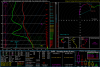
This afternoon's 12z ECMWF is by far & away one of the more ominous looking runs at 500mb by day 7, w/ a strong, negatively tilted s/w trough lifting north thru west Texas and Oklahoma.
.png")
GFS generally follows suit just about 6-12 hours earlier than the ECMWF which is part of the reason why we haven't seen a risk area outlined by the SPC yet although there's almost certainly a legitimate severe threat in this period.

Seems probable if not likely that the SPC will throw down another 15% risk area within the next day or two somewhere in the south-central plains once large-scale timing and evolution is more agreed upon within the models but it's pretty clear the SPC is already keeping an eye on it.
"a strengthening trough farther west is progged to be digging southward along the West Coast, before shifting more eastward/inland Day 6. At this point, model agreement deteriorates significantly with eastward progression/evolution of this system, and thus forecast confidence remains low during the second half of the period."
This afternoon's 12z ECMWF is by far & away one of the more ominous looking runs at 500mb by day 7, w/ a strong, negatively tilted s/w trough lifting north thru west Texas and Oklahoma.
GFS generally follows suit just about 6-12 hours earlier than the ECMWF which is part of the reason why we haven't seen a risk area outlined by the SPC yet although there's almost certainly a legitimate severe threat in this period.