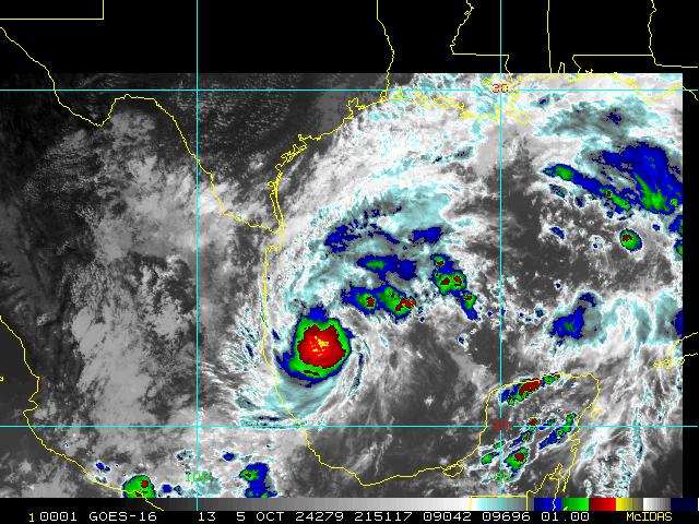
As quickly as it's organizing, an ERC becomes more likely. But they're a two-edged sword; the max winds are eviscerated while the wind field expands. Katrina lost her max punch on landfall but certainly delivered a knockout blow. Any large major hurricane crossing the gulf will deliver a severe punch on landfall.As stated above, classic RI look. I think it intensifies to high 920s/low 930s until it has an eyewall replacement cycle and plateaus a little before weakening.
The forecasting conundrum will be how quickly it weakens. This is a hostile look for a storm:
View attachment 152733
It will be dry- a lot of board members will see real fall mornings this week. That airmass will surround Milton by the time it is approaching Florida. The mixture of shear and eye wall replacements will make dry air intrusions easy - Milton will be in decay by the time it approaches Tampa. When this decay starts probably determines whether this storm is just "bad" or "generationally bad" for Tampa.
But yes it will put on a show before that.
-
Hello, please take a minute to check out our awesome content, contributed by the wonderful members of our community. We hope you'll add your own thoughts and opinions by making a free account!
You are using an out of date browser. It may not display this or other websites correctly.
You should upgrade or use an alternative browser.
You should upgrade or use an alternative browser.
Tropical Major Hurricane Milton
- Thread starter SD
- Start date
0z GFS staying to the northern end of the guidance envelope
itryatmanysportsespgolf70
Member
Picking up on a weakness that's pulling it further nw0z GFS staying to the northern end of the guidance envelopeView attachment 152734
There will almost certainly be an EWRC and I bet it happens after taking in some dry air over the Yucatan like Helene did. The wind field will expand. However, I don't think Katrina is a great comp as Katrina's conditions upon landfall weren't as hostile. Katrina still had a landfall in the 920s- If we get lucky I don't think a sloppy 970+ Cat 2 is out of the question. Once dry air and shear intrude I think Milton's clothes will come off quickly, and the hurricane models show this. The question is- when does that happen, and are they too aggressive with the weakening?As quickly as it's organizing, an ERC becomes more likely. But they're a two-edged sword; the max winds are eviscerated while the wind field expands. Katrina lost her max punch on landfall but certainly delivered a knockout blow. Any large major hurricane crossing the gulf will deliver a severe punch on landfall.
Last edited:
An even further north landfall along the Florida peninsula isn't out of the question IMO. The faster Milton moves, the more intense the storm is when near this position, the further north it would come. It'll be a race to the coast before the trough over Mississippi lifts and the storm is blasted by westerly shear.


Mercy..I’m going to bet the streak on a strengthening major gulf hurricane as it nears landfall. We see it time and time again in the northern gulf. Let’s see if that holds true at this latitude. Tough week ahead for central Florida.
0Z Icon: Sarasota (near 18Z/12Z runs) late afternoon Wed
0Z CMC: Pt Charlotte (a bit N of 12Z’s little S of Ft Myers) Fri morning
0Z GFS: just N of Crystal River (barely N of 18Z) very late Wed night
0Z UKMET: Naples (good bit S of 12Z’s Ft Myers) Wed afternoon
Edit for Euro:
0Z Euro: Bradenton (barely S of 18Z/12Z’s Tampa) Wed evening
Edit: N to S:
GFS, Euro, Icon, CMC, UKMET
-GFS remains quite a N outlier
-UKMET is a pretty significant S outlier
Last edited:
Belle Lechat
Member
- Joined
- Aug 29, 2021
- Messages
- 1,547
- Reaction score
- 1,224

Belle Lechat
Member
- Joined
- Aug 29, 2021
- Messages
- 1,547
- Reaction score
- 1,224

Belle Lechat
Member
- Joined
- Aug 29, 2021
- Messages
- 1,547
- Reaction score
- 1,224
En Route

Henry2326
Member
3 runs of landfall at Cedar Keys for Hwrf.
What ever wasn't destroyed last week, will definitely be gone this week.
Jax gets a beating as it crosses over.


What ever wasn't destroyed last week, will definitely be gone this week.
Jax gets a beating as it crosses over.
Belle Lechat
Member
- Joined
- Aug 29, 2021
- Messages
- 1,547
- Reaction score
- 1,224


Henry2326
Member
06z GFS comes in hotter in pressure. The angle has shifted, puts a cat1 over Jax (2 runs now).


Belle Lechat
Member
- Joined
- Aug 29, 2021
- Messages
- 1,547
- Reaction score
- 1,224

I just dont' know how much of that sharp movement I buy into once It starts to make the approach to FL...Either way, there are a few northernly models *landfall talking about* that are already struggling with the short term motion so let's see how that plays out today.
Henry2326
Member
Dang....ensembles screaming......
.png")
Henry2326
Member
We are on run 3 of Hwfr with the turn. Agreed, if it continues today without flipping back and forth, I'll bet on it.I just dont' know how much of that sharp movement I buy into once It starts to make the approach to FL...Either way, there are a few northernly models *landfall talking about* that are already struggling with the short term motion so let's see how that plays out today.
Looks like the first true pinhole eye I’ve seen in an Atlantic hurricane in years.
Honestly expecting the HH’s find Milton a Cat 4.
Honestly expecting the HH’s find Milton a Cat 4.
NEGaweather
Member
Sent from my iPhone using Tapatalk
Henry2326
Member
This thing is an over achiever. Way ahead of Hwrf, hmon, and the hafs to become a major.
Brent
Member
NHC gonna have a long day
...NOAA HURRICANE HUNTERS FIND MILTON A MAJOR HURRICANE...
Data from a NOAA Hurricane Hunter aicraft indicate that Milton has
strengthened to a major hurricane. The maximum sustained winds are
estimated to be 120 mph (195 km/h). Milton is a category three
hurricane on the Saffir-Simpson Hurricane Wind Scale. Data from
the aircraft also indicate that the minimum pressure has fallen to
954 mb (28.17 inches).
A special advisory will be issued by 7 AM CDT (1200 UTC) to reflect
this change and update the forecast.
SUMMARY OF 600 AM CDT...1100 UTC...INFORMATION
----------------------------------------------
LOCATION...21.9N 92.4W
ABOUT 180 MI...285 KM WNW OF PROGRESO MEXICO
ABOUT 750 MI...1210 KM WSW OF TAMPA FLORIDA
MAXIMUM SUSTAINED WINDS...120 MPH...195 KM/H
PRESENT MOVEMENT...ESE OR 105 DEGREES AT 8 MPH...13 KM/H
MINIMUM CENTRAL PRESSURE...954 MB...28.17 INCHES
943.8 mb.
111600 2149N 09217W 6961 02697 9446 +188 +047 297016 030 026 002 00
111630 2151N 09216W 6962 02687 9438 +190 +049 122015 031 033 001 00
111700 2153N 09216W 6962 02713 9480 +169 +057 110044 049 039 000 03
111730 2154N 09217W 6965 02739 9542 +136 +069 083077 087 /// /// 03
111800 2154N 09220W 6954 02775 9591 +110 +076 056090 092 /// /// 03
Shaggy
Member
He's going to be setting all kinds of RI records
Ol boy said hold my  . I'm making a run for 900mb
. I'm making a run for 900mbIf trends continue, probably will reach that by 12Ol boy said hold my
This is ridiculous

Brent
Member
I knew that image last night was a bad sign but yikes
Still running ahead of even the strongest models...
Still running ahead of even the strongest models...
Only thing that can stop a run to Cat 5 might be the Yucatán
You do have to wonder if it's going to drift south enough that it's going to wreck itself, until then though 
7:00 AM CDT Mon Oct 7
Location: 21.8°N 92.2°W
Moving: ESE at 8 mph
Min pressure: 945 mb
Max sustained: 125 mph
Brent
Member

24H 08/0600Z 21.8N 89.3W 135 KT 155 MPH
Hot towers still firing in the eyewall. I said last night about the 900mb level as more of a joke. I honestly think this may make a run for it in the next twelve hours.
I think it’s possible. All the short term models are busting right now except a few southerly ones. We shall see but heck I agree with youYou do have to wonder if it's going to drift south enough that it's going to wreck itself, until then though
Henry2326
Member
06z HWRF.....4th run in sane spot. Lower pressure to 946.
.png")
Brent
Member
It dropped 6-8 mb in one recon pass
The Yucatan better get busy disrupting it
The Yucatan better get busy disrupting it
Outside of the short term movement, the movement to the NE on a dime is what will be super interesting. Could be a Sarasota or Tampa landfall IMO.
Belle Lechat
Member
- Joined
- Aug 29, 2021
- Messages
- 1,547
- Reaction score
- 1,224
24H 08/0600Z 21.8N 89.3W 135 KT 155 MPH
111400 2151N 09223W 6986 02740 9591 +122 +073 030052 082 134 045 00
Peak 10-second average surface wind speed occurring within the encoding interval from the Stepped Frequency Microwave Radiometer (SFMR), in kt.

Henry2326
Member
Unfortunately not one model predicts that. But we can only hope.You do have to wonder if it's going to drift south enough that it's going to wreck itself, until then though