Eye now surrounded by very cold cloud tops

-
Hello, please take a minute to check out our awesome content, contributed by the wonderful members of our community. We hope you'll add your own thoughts and opinions by making a free account!
You are using an out of date browser. It may not display this or other websites correctly.
You should upgrade or use an alternative browser.
You should upgrade or use an alternative browser.
Tropical Major Hurricane Helene
- Thread starter SD
- Start date
- Status
- Not open for further replies.

Think I'll head down to my old stomping grounds in Macon this evening and try to catch what's left of the east eyewall overnight
Local Mets ain’t slashing. @Rain Cold make the call please 
- Joined
- Jan 5, 2017
- Messages
- 3,794
- Reaction score
- 6,035
That gap of no convection is not the eye. The COC is to the NW under cloud cover. That gap is likely more dry air being pulled in to the COC.Eye now surrounded by very cold cloud tops
Mahomeless
Member
- Joined
- Oct 17, 2023
- Messages
- 900
- Reaction score
- 2,158
Appears due north for quite a few frames....and with the blow up of convection on the SE side of the COC, maybe even a little NNW component to it in the last couple of frames. Any westward component would only be wobbles though, as the general motion is going to be north or somewhat northeast with the steering currents.Eye now surrounded by very cold cloud tops
Mahomeless
Member
- Joined
- Oct 17, 2023
- Messages
- 900
- Reaction score
- 2,158
Correct....however I think that dry air will wrap up, get spit out, and essentially become the mechanism for the eye to form as that process occurs.That gap of no convection is not the eye. The COC is to the NW under cloud cover. That gap is likely more dry air being pulled in to the COC.
GSP wayyyyy upped their numbers
lexxnchloe
Member
The good news is it is having a hard time while running out of time.That gap of no convection is not the eye. The COC is to the NW under cloud cover. That gap is likely more dry air being pulled in to the COC.
ChattaVOL
Member
Holy….GSP wayyyyy upped their numbersView attachment 152009
10-14% shaded area just added for Friday for SE NC/NE SC:

Last edited:
MichaelJ
Member
Be careful with the intensification not being elevated at this point. This is going over warm water in a relatively low shear area and it has plenty of time to explode before reaching Fl. The one saving grace as it approaches Fl is the relatively shallow water it will enter just before landfall. I have seen many storms lose intensity in the gulf as it encounters shallower waters
Banter, but I don’t care. I never in my life thought I’d see that for my homeGSP wayyyyy upped their numbersView attachment 152009
NEGaweather
Member
Sent from my iPhone using Tapatalk
Nerman
Member
So you don't think it's heading toward Chattanooga?Atlanta will be on the far weaker west side. I’m thinking 30-40.

Where did you get that? Feels like an errorGSP wayyyyy upped their numbersView attachment 152009
Attachments
Mahomeless
Member
- Joined
- Oct 17, 2023
- Messages
- 900
- Reaction score
- 2,158
Explosions on the E, NNE, and NW side of COC.....she's trying
jaymackd3
Member
958
We have some 100 knot flight-level winds in the SE quadrant. Helene is contracting the outer wind maximum. I do believe liftoff is imminent.

GSP twitter also doesn’t show that crazy map
BufordWX
Member
Tornado down in southern Bamberg county SC.
It appears that Allen Huffman reposted the rainfall graphic of 20-30 inches in Brevard area. So, there's the legs to that photo just posted.
chuckhendo
Member
I believe the map was also showing all of the rain that's already occurred since 2am this morning. Not saying it's right, but that could be the differenceGSP twitter also doesn’t show that crazy map
JimRussell
Member
it sure looks like she's about to get mean....
Snow_chaser
Member
This is from Glenn Burns:
Just out of a conference with our NWS office. Here is what I learned.
1. Storm is expected to be a low end Cat 3
at landfall
2. Do not concentrate on center. The
wind field is HUGE, at the upper end of
the scale
3. This will still be an unprecedented
event with rain and wind gusts of
50-70 mph.
during the overnight hours
4. Rainfall will increase in intensity
overnight with 4-6 additional inches
and up to 8 inches for NE mountains
5. Winds will increase in north Georgia
with tropical storm force SUSTAINED
winds moving north into Macon around
midnight and 3 am in the metro, then
6 am in far north Georgia.
6. Severe threat for brief spin up
tornadoes are more likely in southeast
Georgia.
7. The EXACT track is still in flux and
will be until we see exactly where land
fall occurs.
8. High probability of trees and
powerlines going down. Power
outages will be very likely.
9. As the storm moves in our winds will
be from the east and southeast. As.
It passes winds will change direction
and will be from the west and
northwest. When this happens,
winds will be the strongest. Trees
blowing one way will then be blown
another way…many will go down.
10. Our NWS projected path is east of
the NHC official forecast. We will get
an update at 4 pm.
Hope this answers some of your questions
Where did you get that? Feels like an error
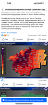
Hydrology Briefing Page
www.weather.gov
Here’s where I got the map
Hydrology Briefing Page
www.weather.gov
Here’s where I got the map
Something does seem strange since it doesn’t match their three-day map, either.
Three day map is this morning through Saturday. Storm total looks to be the overall event including yesterdaySomething does seem strange since it doesn’t match their three-day map, either.
Maybe. Even though the map doesn’t say that lol
From Scot:
Blue_Ridge_Escarpment
Member
T
Anyone who cannot see a NNW component right now, needs to have their eyes examined.

DCK
Member
In layman terms that means?
Eye will clearIn layman terms that means?
Belle Lechat
Member
- Joined
- Aug 29, 2021
- Messages
- 1,547
- Reaction score
- 1,224
TORNADO WARNING TALLAHASSEE FL - KTAE 135 PM EDT THU SEP 26 2024
TORNADO WARNING COLUMBIA SC - KCAE 126 PM EDT THU SEP 26 2024
TORNADO WARNING COLUMBIA SC - KCAE 126 PM EDT THU SEP 26 2024
SnowwxAtl
Member
It seems like the eye has got rid of the mid level dry air and is about to RI is my guess.In layman terms that means?
We've been saying that for the past 24 hoursCorrect....however I think that dry air will wrap up, get spit out, and essentially become the mechanism for the eye to form as that process occurs.
Sure glad she waited to get her act together after the loop current. Cat 3 looking likely. Hopefully nothing more.
And this is a VERY interesting read of pressure vs windspeed vs hurricane size:
- Status
- Not open for further replies.