posted 20 mins ago?This is old
-
Hello, please take a minute to check out our awesome content, contributed by the wonderful members of our community. We hope you'll add your own thoughts and opinions by making a free account!
You are using an out of date browser. It may not display this or other websites correctly.
You should upgrade or use an alternative browser.
You should upgrade or use an alternative browser.
Tropical Major Hurricane Helene
- Thread starter SD
- Start date
- Status
- Not open for further replies.
Makeitsnow
Member
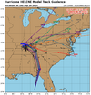
Looks like the 18z tropical models have shifted a bit east.
Banter again but once again don’t discount the northern gulf
Looks like the 18z tropical models have shifted a bit east.
severestorm
Member
Eye looks like it's clearing out on IR or is that dry air again?
Henry2326
Member
DittoBetting on 140 mph cat 4
Ron Burgundy
Member
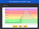
Just went over 5” on my station. In about 24 hours. Guessing we’ll be flirting with a total of 10” before it’s all done
Drizzle Snizzle
Member
3.05” so far.
Henry2326
Member
SnowwxAtl
Member
Definitely East of Atlanta!
dsaur
Member
Just put out my strictly hurricane bucket a few hours ago, and already have 1 3/8's in there. That gets me over 5 too. Edit: the Experiment Station has 1.54. Just got a flash flood warning with another 3 inches possible thru the period. Fun, squishy times ahead. On top of 1 to 1.5 having already fallen since midnight.Just went over 5” on my station. In about 24 hours. Guessing we’ll be flirting with a total of 10” before it’s all done
Last edited:
I’m live nothing exciting now but will be
Oh my

Lightning popping off around the center 
severestorm
Member
Nerman
Member
Henry2326
Member
Good Lord....a beast.Oh my

Drizzle Snizzle
Member
No chanceCan she make it to 5?
Mahomeless
Member
No….may not make low end cat 4Can she make it to 5?
severestorm
Member
Henry2326
Member
956.....she's making a run for it.....
RDUHeatIsland
Member
956.....she's making a run for it.....
Maybe a little more gas in the tank but looking at IR and radar, I don’t know how much more.
How much time before Helene makes landfall? Looks like she is going to make a run for cat 4.
HugeSnowStick
Member
5.93 inches from yesterday to current, very heavy rain ongoing..
Henry2326
Member
Landfall - Hwrf says 3 am. 11 hours!!!!!How much time before Helene makes landfall? Looks like she is going to make a run for cat 4.
Hwrf pressure at landfall forecasted 941 and Hmon 939.
RDUHeatIsland
Member
The eye is still not symmetrical.
chuckhendo
Member
I think that’s 3 Zulu timeLandfall - Hwrf says 3 am. 11 hours!!!!!
Hwrf pressure at landfall forecasted 941 and Hmon 939.
lexxnchloe
Member
Henry2326
Member
So add 5 hours? 3am becomes 8 am?I think that’s 3 Zulu time
LovingGulfLows
Member
- Joined
- Jan 5, 2017
- Messages
- 1,498
- Reaction score
- 4,089
So add 5 hours? 3am becomes 8 am?
Zulu time is basically GMT time. 3Z is 11pm EST.
rburrel2
Member
Most of the models have the pressure bottoming out around 7pm, then rising 1 or 2mb at landfall a few hours later. As such, we still have 3-4 hours of pressure falls to come i'd say, and the winds haven't caught up to the 10mb drop we've had in the last few hours. I think 140-145mph is easily attainable.

952 mb.
WRAL weather is watching rotation over Johnson County moving north toward Wake.
lexxnchloe
Member
951mb. Thats a low pressure for 120 mph. This may be a rare case where cat 3 winds verify on land
- Status
- Not open for further replies.

