• Hello, please take a minute to check out our awesome content, contributed by the wonderful members of our community. We hope you'll add your own thoughts and opinions by making a free account!

Tropical Major Hurricane Helene

Too many icon and HAFS A postings skew the reality all models have been coming west slowly that we're east. I'm expecting the brunt of the storm here or N GA between the training storms and the gusts as the eye approaches its going to be rough.
Worst case keeps getting worser for ATL and GA 400 corridor
 
Too many icon and HAFS A postings skew the reality all models have been coming west slowly that we're east. I'm expecting the brunt of the storm here or N GA between the training storms and the gusts as the eye approaches its going to be rough
Among other things, what's unusual about this storm is the highest rainfall totals look to be near and to the west of the track while the strongest winds will of course be on the east side.
 
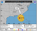
Obviously the 0z spaghetti plots have shifted west. However they are all still with the cone of error that the NHC has kept fairly close to the same ever since they first started issuing advisories. Another thing to keep in mind is that it has seemed the last couple years that storms have wanted to follow closer to the right side of those plots. There is still a lot of real estate for this storm to cover so I would certainly expect shifts either way
 
I’m not real sold on a really high intensity at landfall. Cat 3 probably, but this is a perfect scenario for unforeseen shear and the huge amount of dry air in the gulf to crush the core as it approaches.
There’s not a lot of dry in the Gulf right now by the looks of the water vapor image. Definitely not anywhere close to what was showing yesterday. It looks like John might have pushed some moisture into the Gulf
 
There’s not a lot of dry in the Gulf right now by the looks of the water vapor image. Definitely not anywhere close to what was showing yesterday. It looks like John might have pushed some moisture into the Gulf

Not yet, but there will be as the ULL pumps it down. If the storm keeps a strong core, it could hold the dry air out, but it could do a number on the storm if it penetrates.

1727230655987.png
 
Back
Top