lexxnchloe
Member
Looks a little less organized to me. Doesnt have alot of time over water as it accelerates.
Meaning?Latest dropsonde shows Cat 3 winds in the 942-889 mb level. View attachment 151979
Help explain in layman’s terms
Sorry. I edited the post to help explain it better.Meaning?
I hope you're right.....but that's a heck of a jump for the NHC.I would expect Atlanta to be on the very west edge of the NHC cone at 11 AM.
I wouldn’t. They are being stubbornI would expect Atlanta to be on the very west edge of the NHC cone at 11 AM.
Latest dropsonde shows Cat 3 winds in the 942-889 mb level in the E Quad. Probably take a while to mix down. View attachment 151979
She's very lopsided. Is the shear taking it's toll?No hurricane force FL winds in NW quad
Help explain in layman’s terms
You called it. Color me shocked.I wouldn’t. They are being stubborn
I know there are certainly a ton of twitter and reddit alarmist posts, but to be fair though it was looking pretty dicey for ATL with a lot of signs pointing to a historic event up here that would make Irma and Opal look like child's play........ BUT I think it was all dependent on Helene getting its s*** together through the night, and while it has intensified, it has been nowhere near worst-case scenario. I wonder if this affected the track some which is why we're seeing the more eastern solutions become more likely as time goes on. Anyway, it still has another 300ish miles or more of warm ocean to cross, so we'll see what ends up happening.The fear mongering by some on Twitter was a bit much yesterday. Looking like 4-6 inches of rain and 30-40 mph gust.
For sure. And as MBY is 40 miles east of downtown Atlanta, I have a special interest to see if that NHC track pans out.I’m just so fascinated to see how this pans out for Atlanta. NHC still putting the center right over
View attachment 151988
If the track holds, then you would possibly be in the worst location.For sure. And as MBY is 40 miles east of downtown Atlanta, I have a special interest to see if that NHC track pans out.
She's very lopsided. Is the shear taking it's toll?
The cone as a whole tho looks to still be adjusting east, now the state line of Alabama/Georgia is right on the western edge where it did go into eastern Alabama before.I’m just so fascinated to see how this pans out for Atlanta. NHC still putting the center right over
View attachment 151988
The center line moved about 10 miles west fwiw. Guess they’re tightening up the cone as we get closerThe cone as a whole tho looks to still be adjusting east, now the state line of Alabama/Georgia is right on the western edge where it did go into eastern Alabama before.
No the cone at 5am did not show it going through Alabama, but now the cone shows it a little closer to the GA/AL border.The cone as a whole tho looks to still be adjusting east, now the state line of Alabama/Georgia is right on the western edge where it did go into eastern Alabama before.
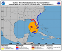
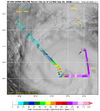
Whereas the Dvorak graph supposedly shows the radius to which hurricane force winds extend in the NW quadrant, as indicated by the R64 red line, R64 meaning a radius of 64 knots, or 73.65 mph, and the box in the lower corner saying the hurricane force winds in the NW quadrant extend out 25.0 n.mi., the recon graph has the wind speed barbs showing there aren't hurricane force winds in the NW quadrant.


I still think the worst of the winds will be east of a dawsonville to Lawrenceville to Forsyth line.(gusts at or over 60). I'm having a real difficult time understanding the nhcs reasoning being so far west when just about every model is to the east...some well to the east of their track. It's rather frustrating they still wont address their reasoning. My neck of the woods/Athens area seems poised to be slammed regardless...but it seems obvious very strong winds are going to be extended well into the Carolinas. One just hopes people there aren't caught off guard because they see the nhc track so far to the west.For sure. And as MBY is 40 miles east of downtown Atlanta, I have a special interest to see if that NHC track pans out.
Based on modeling, the center is far more likely to go over Athens than Atlanta.I still think the worst of the winds will be east of a dawsonville to Lawrenceville to Forsyth line.(gusts at or over 60). I'm having a real difficult time understanding the nhcs reasoning being so far west when just about every model is to the east...some well to the east of their track. It's rather frustrating they still wont address their reasoning. My neck of the woods/Athens area seems poised to be slammed regardless...but it seems obvious very strong winds are going to be extended well into the Carolinas. One just hopes people there aren't caught off guard because they see the nhc track so far to the west.
Same here, the rain is enough for me! More worried about my daughter at Statesboro than I am here. Track verification should interesting to say the least,I am really hoping our resident hobbyist and Mets on this board are more correct than the NHC and that cone is straddling the Eastern GA border on the next update. Not looking forward to being without power for days on end and that would save us from that though I worry about our guys to the East of us. I know most of you do not want this either, Good luck to all and especially property owners here.
