-
Hello, please take a minute to check out our awesome content, contributed by the wonderful members of our community. We hope you'll add your own thoughts and opinions by making a free account!
You are using an out of date browser. It may not display this or other websites correctly.
You should upgrade or use an alternative browser.
You should upgrade or use an alternative browser.
Tropical Major Hurricane Helene
- Thread starter SD
- Start date
Belle Lechat
Member
- Joined
- Aug 29, 2021
- Messages
- 1,097
- Reaction score
- 847
TORNADO WARNING COLUMBIA SC - KCAE 1056 AM EDT THU SEP 26 2024
TORNADO WARNING TALLAHASSEE FL - KTAE 1055 AM EDT THU SEP 26 2024
TORNADO WARNING TALLAHASSEE FL - KTAE 1051 AM EDT THU SEP 26 2024
TORNADO WARNING TALLAHASSEE FL - KTAE 1055 AM EDT THU SEP 26 2024
TORNADO WARNING TALLAHASSEE FL - KTAE 1051 AM EDT THU SEP 26 2024
mydoortotheworld
Member
I know there are certainly a ton of twitter and reddit alarmist posts, but to be fair though it was looking pretty dicey for ATL with a lot of signs pointing to a historic event up here that would make Irma and Opal look like child's play........ BUT I think it was all dependent on Helene getting its s*** together through the night, and while it has intensified, it has been nowhere near worst-case scenario. I wonder if this affected the track some which is why we're seeing the more eastern solutions become more likely as time goes on. Anyway, it still has another 300ish miles or more of warm ocean to cross, so we'll see what ends up happening.The fear mongering by some on Twitter was a bit much yesterday. Looking like 4-6 inches of rain and 30-40 mph gust.
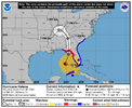
For sure. And as MBY is 40 miles east of downtown Atlanta, I have a special interest to see if that NHC track pans out.I’m just so fascinated to see how this pans out for Atlanta. NHC still putting the center right over
View attachment 151988
Drizzle Snizzle
Member
If the track holds, then you would possibly be in the worst location.For sure. And as MBY is 40 miles east of downtown Atlanta, I have a special interest to see if that NHC track pans out.
She's very lopsided. Is the shear taking it's toll?
Shear, dry air, increasing speed, lots of different variables. It’s not uncommon at all for quick moving hurricanes being influenced by upper troughs to be really one sided. Now the east sides are really nasty though.
Snow_chaser
Member
The cone as a whole tho looks to still be adjusting east, now the state line of Alabama/Georgia is right on the western edge where it did go into eastern Alabama before.I’m just so fascinated to see how this pans out for Atlanta. NHC still putting the center right over
View attachment 151988
Ron Burgundy
Member
The center line moved about 10 miles west fwiw. Guess they’re tightening up the cone as we get closerThe cone as a whole tho looks to still be adjusting east, now the state line of Alabama/Georgia is right on the western edge where it did go into eastern Alabama before.
Drizzle Snizzle
Member
No the cone at 5am did not show it going through Alabama, but now the cone shows it a little closer to the GA/AL border.The cone as a whole tho looks to still be adjusting east, now the state line of Alabama/Georgia is right on the western edge where it did go into eastern Alabama before.
tractor girl
Member
I'm calling a strong CAT 2 or weak CAT 3 on landfall. It does not look good and hasn't looked good since leaving Yucatan
Belle Lechat
Member
- Joined
- Aug 29, 2021
- Messages
- 1,097
- Reaction score
- 847
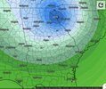
Whereas the Dvorak graph supposedly shows the radius to which hurricane force winds extend in the NW quadrant, as indicated by the R64 red line, R64 meaning a radius of 64 knots, or 73.65 mph, and the box in the lower corner saying the hurricane force winds in the NW quadrant extend out 25.0 n.mi., the recon graph has the wind speed barbs showing there aren't hurricane force winds in the NW quadrant.
I started to update my post above, but I'll respond to it instead. Despite recon showing no hurricane force winds in the NW quadrant, the NHS map shows no hurricane force winds in the SW quadrant.
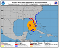
So that's 3 sources saying different things. I assume recon has the correct information since it has actual data you can check.
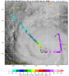
There's a plane in the SW quadrant right now, so we're about to get new readings.
Last edited:
I am really hoping our resident hobbyist and Mets on this board are more correct than the NHC and that cone is straddling the Eastern GA border on the next update. Not looking forward to being without power for days on end and that would save us from that though I worry about our guys to the East of us. I know most of you do not want this either, Good luck to all and especially property owners here.
Last edited:
Makeitsnow
Member
I still think the worst of the winds will be east of a dawsonville to Lawrenceville to Forsyth line.(gusts at or over 60). I'm having a real difficult time understanding the nhcs reasoning being so far west when just about every model is to the east...some well to the east of their track. It's rather frustrating they still wont address their reasoning. My neck of the woods/Athens area seems poised to be slammed regardless...but it seems obvious very strong winds are going to be extended well into the Carolinas. One just hopes people there aren't caught off guard because they see the nhc track so far to the west.For sure. And as MBY is 40 miles east of downtown Atlanta, I have a special interest to see if that NHC track pans out.
WPC with a large high risk of flooding
Based on modeling, the center is far more likely to go over Athens than Atlanta.I still think the worst of the winds will be east of a dawsonville to Lawrenceville to Forsyth line.(gusts at or over 60). I'm having a real difficult time understanding the nhcs reasoning being so far west when just about every model is to the east...some well to the east of their track. It's rather frustrating they still wont address their reasoning. My neck of the woods/Athens area seems poised to be slammed regardless...but it seems obvious very strong winds are going to be extended well into the Carolinas. One just hopes people there aren't caught off guard because they see the nhc track so far to the west.
And yes, it's beyond frustrating the NHC continues to not explain their reasoning. Especially in this social media age with so much modeling data available to the layman.
WXinCanton
Member
Same here, the rain is enough for me! More worried about my daughter at Statesboro than I am here. Track verification should interesting to say the least,I am really hoping our resident hobbyist and Mets on this board are more correct than the NHC and that cone is straddling the Eastern GA border on the next update. Not looking forward to being without power for days on end and that would save us from that though I worry about our guys to the East of us. I know most of you do not want this either, Good luck to all and especially property owners here.

