Brent
Member
51.88" new rainfall record for the CONUS from a tropical system per NWS Houston
Impressive. Euro had an amount of around 52 inches on a run leading up to the event (it was to the SW of Houston), but not too shabby on it's part!51.88" new rainfall record for the CONUS from a tropical system per NWS Houston
Dade Phelan @DadePhelan 15h15 hours ago
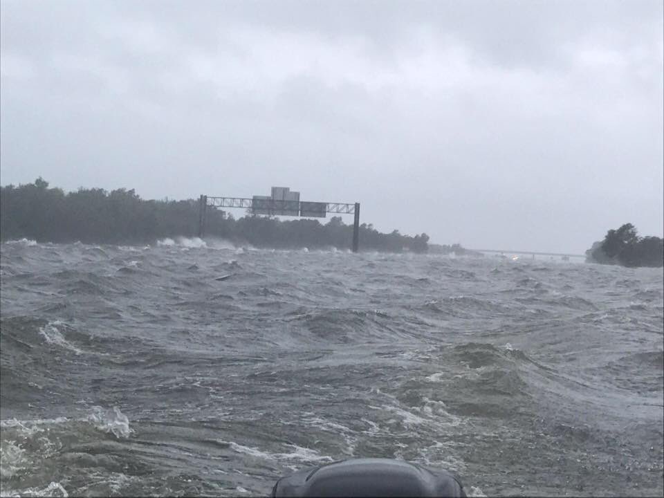
Interstate 10 at the Jefferson / Chambers county line. Waves with white caps on the interstate. #Harvey
Ahh that makes sense thought it looked like the overhead interstate signs were off at an angle so they are actually probably over the ditch, but as you say still very impressive.... good clarification though, pics can be worth a thousand words but also deceiving.That was what I thought too until someone posted the other pics on Facebook. That boat is riding off the interstate. On the left of the picture you see the waves splashing. That is the interstate concrete barriers. The pictures I saw showed the interstate still passable.
That said, it still is very impressive, but not quite what you believe at first glance.
Yeah this going to be next threat with HarveyA couple of tornado warnings in Southern Miss. South and East of Jackson moving due North.

In upstate SC, no shortages, but gouging! Up to 2.50$ a gallon , after being under 2$ right before Harveyseeing reports of gas shortages around here...
Here go the gas prices...In upstate SC, no shortages, but gouging! Up to 2.50$ a gallon , after being under 2$ right before Harvey
There is always some reason to raise gas prices. I've never seen such a fragile productHere go the gas prices...
http://abc11.com/southern-gasoline-pipeline-to-shut-down-due-to-harvey/2361523/
Lots of sunshine here in west ga.Looks like we are getting dry slotted here lol. Been cloudy most the day with intermittent sprinkles. It did rain quite a bit last night tho.
Sent from my iPhone using Tapatalk
Lots of sunshine here in west ga.

Gas is going nuts here. Jumped from $2.24 Monday to $2.59 today. Some stations nearby have $2.69 and one has $2.75. It's crazy.State of emergency in NC. Gas Shortages en route per govenor. Colonial pipeline
I filled up this morning and it was $2.35. Now its up to $2.60.Gas is going nuts here. Jumped from $2.24 Monday to $2.59 today. Some stations nearby have $2.69 and one has $2.75. It's crazy.
Gas went from 2.23 to 2.59 overnight herefilled up last friday at 2.09
Filled up last night at 2.59
Tons of stations around here have taken a jump again. Lots of $2.75 stations around. Cheapest remains Costco at $2.25, but I expect it too to jump tonight.Gas went from 2.23 to 2.59 overnight here
Sent from my SM-J320VPP using Tapatalk