Something to watch because from the look of things this storm got South Carolina written all over it.Invest 95L definitely seems to be a culprit in the evolution of this SE US ridge west and north of Florence around day 3, notice even w/ a weaker Atlantic ridge, the flank of the high over the SE US intensified (likely due to excess outflow from this invest (which might become Joyce), hence the turn west into SC.
View attachment 6163
-
Hello, please take a minute to check out our awesome content, contributed by the wonderful members of our community. We hope you'll add your own thoughts and opinions by making a free account!
You are using an out of date browser. It may not display this or other websites correctly.
You should upgrade or use an alternative browser.
You should upgrade or use an alternative browser.
Tropical Major Hurricane Florence
- Thread starter ForsythSnow
- Start date
That would put N GA & E TN in impactsYou can see the left bend after landfall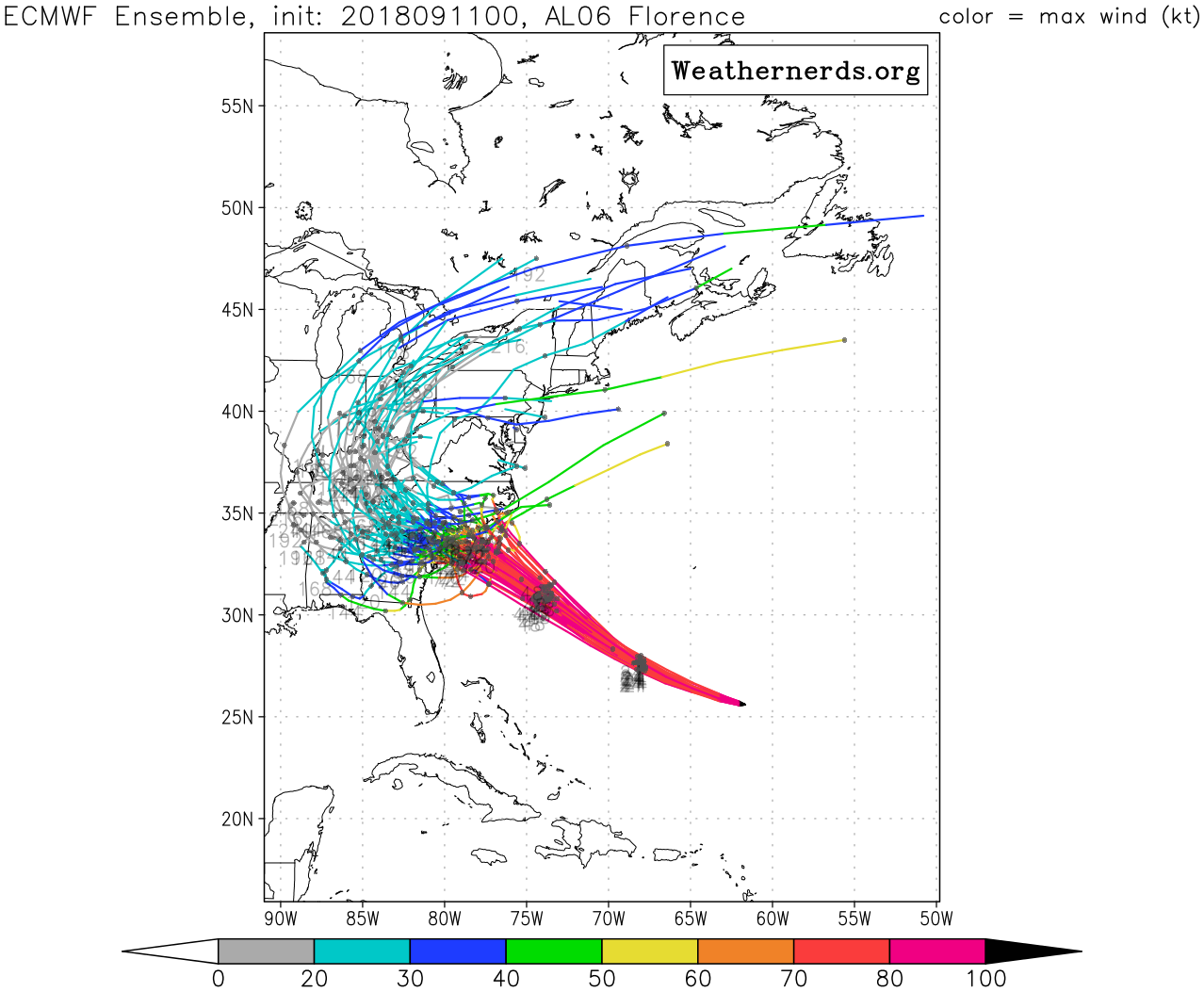
Webberweather53
Meteorologist
According to ATCF, virtually no change is coming on the 5am advisory for Florence with MSLP coming up a few mb.
FWIW: 6z Nam have a much stronger ridge.
stronger ridge, no loop foolishness? gfs on bath salts?
Ummm looking a little annular;

Webberweather53
Meteorologist
From the NHC's 5pm discussion on Florence, they already noted 95L's potential influence on the strength of the ridge steering florence.

Brent
Member
 A STORM SURGE WATCH HAS BEEN ISSUED FOR THE EAST COAST OF THE
UNITED STATES FROM EDISTO BEACH...SOUTH CAROLINA NORTHWARD TO
THE NORTH CAROLINA-VIRGINIA BORDER...INCLUDING THE PAMLICO AND
ALBEMARLE SOUNDS.
A HURRICANE WATCH HAS BEEN ISSUED FOR THE EAST COAST OF THE UNITED
STATES FROM EDISTO BEACH... SOUTH CAROLINA... NORTHWARD TO THE
NORTH CAROLINA-VIRGINIA BORDER... INCLUDING THE PAMLICO AND
ALBEMARLE SOUNDS.
Last edited:
Webberweather53
Meteorologist
EPS rainfall, obviously these totals will be much higher than this over the affected areas but you get the general idea where the heaviest swath may be.
.png")
packfan98
Moderator
What are your current thoughts? Are you going to post a forecast map? Thanks!EPS rainfall, obviously these totals will be much higher than this over the affected areas but you get the general idea where the heaviest swath may be.
ForsythSnow
Moderator
If that looks just like my cone in my map...0z EPS, note more members into SC vs NC this run. The idea touted yesterday that the ECMWF was overamping the ridge is becoming hogwash esp with 95L developing in the Gulf of Mexico and strengthening the flank of the high over the SE US thru -PV deposition.
View attachment 6162
Florence definitely taking on an annular shape this morning and the Euro seems to have the same idea I have about how this system could behave as it makes landfall. Probably a blend of the 2 lines I put in. The rain is going to be crazy in Wilmington to Raleigh with the crawl inland. But hey, at least us in N GA are getting some rain later on per the Euro.
Webberweather53
Meteorologist
What are your current thoughts? Are you going to post a forecast map? Thanks!
If I were to produce a forecast map I would place the track of Florence over Myrtle Beach as a mid-high grade (105-110 KT) category 3 hurricane, anticipating that the apparent deceleration in its track over shallower shelf water, increasing southwesterly shear, etc would weaken the hurricane, potentially knocking it back to a category 3 before making landfall.
Ummm looking a little annular;
View attachment 6165
Could be, but it also just could be the buzzsaw look that many hurricanes do before intensification. Katrina and Andrew are two that come to mind.
Eye looks a little ragged this morning!!
But imagine my surprise going to bed with almost 0 impacts imby, and waking up to 8-12”+ of rain imby!!? All hail king Euro!! I don’t understand the rainfall map forecast shows the West bend to over my way, but cone still looks the same last night, over toward RAH?
But imagine my surprise going to bed with almost 0 impacts imby, and waking up to 8-12”+ of rain imby!!? All hail king Euro!! I don’t understand the rainfall map forecast shows the West bend to over my way, but cone still looks the same last night, over toward RAH?
Definitely going through ERC at the moment!!
 This cone! Should look different soon?
Gfs is definitely further north and east of Euro. When are we going to get them two models to come on line.

Storm5
Member
I hope our SC friends have been preparing as well .....
Sent from my iPhone using Tapatalk
Sent from my iPhone using Tapatalk
Blue_Ridge_Escarpment
Member
The governor is looking very smart right now.I hope our SC friends have been preparing as well .....
Sent from my iPhone using Tapatalk