BHS1975
Member
Yeap final blow.
Those SSTs are boiling. The sky is the limit.
She’s a women so she is always pissed. ?Mother nature is pissed.
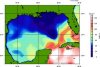
But not boiling in the N Gulf thank goodness! They're near normal for early October with nice cooling from the peak thanks to several cold fronts. But if Delta were to come in as a cat 4 like the HWRF shows and with it not moving slowly, LA would still likely be looking at a cat 3 landfall.
Mother nature is pissed.


Katrina was a 5 and made LF as a 3,Right? Even though it was weakening at LF,the cat 5 surge was well on its way. Correct me if im wrong. Thats what I always worry about in NO,is the surge, pressure on the levees etc.This is looking to be a horrible run for New Orleans.


Katrina was a 5 and made LF as a 3,Right? Even though it was weakening at LF,the cat 5 surge was well on its way. Correct me if im wrong. Thats what I always worry about in NO,is the surge, pressure on the levees etc.
Good news with this one is we will not have a peaking storm making landfall. Delta will be in the decline or even rapid decline by the time it’s close to the US coast.
Doesn’t mean impacts will be small or insignificant but thankfully we aren’t looking at a “doomsday” scenario.
26.5c is regarded as the bottom end threshold for hurricanes. With a nice portion of the gulf below that point Delta will be a declining storm upon landfall. The question is how high does it get before temps drop off.
12z euro gets it into the 960s before declining to the 990s at landfall.
The recent hwrf is a bomb but also weakens abt 30mb from peak before landfall.
All good news!
View attachment 49825View attachment 49826
Can the water temps warm over the next few days before arrival?
They will cool a bit if anything.
Sent from my iPhone using Tapatalk
Reality might have it we see a major tomorrow. Just the way we are headed.We have HWRF, HMON, and NAM going for a major three days upon arrival.....this will not be pretty.


Reality might have it we see a major tomorrow. Just the way we are headed.
Yup....NHC says reasonable to believe that rapid intensification will continue in the short term.I mean we went from a PTC to a hurricane in a day
The sky is the limit the next couple of days other than the Yucatan

A center relocation in a hurricane? Odd
POORLY DEFINED EYE W/RAGGED BANDS ON S SIDE, OPEN N.
WEAK RADAR SIGNATURE ~5 MI NE OF FIX (ONLY 2 MI WIDE) INDICATED NEW
PSBL LLC DEVELOPING, BUT FL WINDS DID NOT YET SUPPORT THIS FEATURE.
;
If this gets a 2 mile wide eye though Cancun is screwed
.png")

HMON is pretty similar.The HWRF basically has a Cat 5 hitting Cancun
This storm was headed for Western Cuba yesterday...
View attachment 49834View attachment 49835

 .
.

.png")
Well she doesn’t seem to be struggling that’s for sure .. rapidly just intensified into a CAT 2 hurricane ... buckle up we have all day of warm water and great conditions for this thing.. boutta see it pop an eye any hour now
They were saying yesterday it might make it to a car 2, now NHC saying cat 4 is possible now! Now dropped 74 MB in 24 hours, per TWC
"Car 2"??They were saying yesterday it might make it to a car 2, now NHC saying cat 4 is possible now! Now dropped 74 MB in 24 hours, per TWC