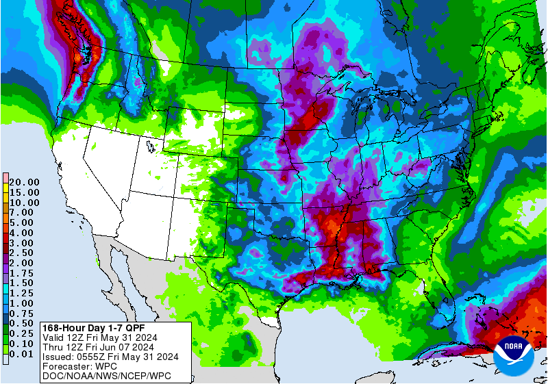
Did anyone post a QPF map for the Carolinas and NE Georgia?Yeah.. the angle of approach, interaction with the wedge front and cold front sets up a perfect upslope for those areas..
-
Hello, please take a minute to check out our awesome content, contributed by the wonderful members of our community. We hope you'll add your own thoughts and opinions by making a free account!
You are using an out of date browser. It may not display this or other websites correctly.
You should upgrade or use an alternative browser.
You should upgrade or use an alternative browser.
Tropical Major Hurricane Delta
- Thread starter Ollie Williams
- Start date
-
- Tags
- tropical
CentralALWX
Member
Did anyone post a QPF map for the Carolinas and NE Georgia?
This is the 7 day QPF total.

Henry2326
Member
Yup, strange....they have been fighting until almost 24 hours.....hopefully folks will evacuate.Models really converging on this area now.
I’m not sure if anyone has mentioned this, but if the eye goes over the Yucatán, there will be a little weakening, but keep in mind that it’s would going over pretty flat terrain and moving at steady speed so the weakening would not be as much as it would if it moved over Cuba. Also as it emerges into the Gulf, it should have a more expansive wind field than what we see now.
BufordWX
Member
CAT 4 approaching CAT 5 and we still don’t have a cleared out eye? Hmmmm I haven’t seen a storm with no cleared out eye that is this strong .. very interesting .. would assume she has to pop one out here soon we can’t go CAT 5 with NO clear eye right?
Wilma.
145 mph sustained
Oh my
FORECAST POSITIONS AND MAX WINDS
INIT 06/2100Z 18.9N 84.1W 125 KT 145 MPH
12H 07/0600Z 20.2N 86.1W 135 KT 155 MPH
24H 07/1800Z 21.8N 88.8W 105 KT 120 MPH
36H 08/0600Z 23.0N 91.1W 110 KT 125 MPH
48H 08/1800Z 24.4N 92.6W 115 KT 130 MPH
60H 09/0600Z 25.9N 93.2W 115 KT 130 MPH
72H 09/1800Z 28.0N 92.9W 110 KT 125 MPH
96H 10/1800Z 32.4N 90.9W 55 KT 65 MPH...INLAND
Besides Michael, has there been another storm that has undergone such rapid intensification?
That SE rain has a “rabbit” look to it! ?This is the 7 day QPF total.

SD, I am not so sure this barely makes it on shore. I think this might just scrap the NE side.Really thought that it would start to weaken as it approached the coast.... Maybe not
Besides Michael, has there been another storm that has undergone such rapid intensification?
Wilma of 2005
Brent
Member
Henry2326
Member
?That SE rain has a “rabbit” look to it! ?
I think Delta is gaining a little more lat...almost a NW vs a WNW. Northern quad is stretching northward a bit. I wouldn't' be surprised to see this get very close to missing land.
Dewpoint Dan
Member
Patricia in 2015 intensified 120 mph in 24 hrs. She maxed out at 215 i believe.Besides Michael, has there been another storm that has undergone such rapid intensification?
Looks like this might have a shot at making landfall as a cat 5 in the Yucatan.
accu35
Member
Delta looks to be moving more NW than WNW. That's gonna be a game changer of the track if it misses the land
Henry2326
Member
Fountainguy97
Member
mydoortotheworld
Member
shear has, for the most part, been a big theme for this year. Thankfully
Brent
Member
Pressure up that pass 959.8 mb
Winds are meh too on the weaker side though
Small storm much more likely to have extreme swings
Winds are meh too on the weaker side though
Small storm much more likely to have extreme swings
Last edited:
Is there any signs of a possible EWRC occurring? Levi kinda hinted at the possibility in his most recent video.
Stormsfury
Member
Is there any signs of a possible EWRC occurring? Levi kinda hinted at the possibility in his most recent video.
NHC didn't note any outer eyewalls as the last recon left but I'm betting on the very small 5nm eye collapsed.
First initial pass of new recon NW and SE quads show only 90 to 95kt flight level winds...and a 962mb plot (from TT)
Looks like it slowed a bit as well.
Showmeyourtds
Member
Looks like it slowed a bit as well.
Does the motion look like it has changed at all? I seem to remember these things kind of pivoting before a change in heading.
Fountainguy97
Member
Brent
Member
Crazy the winds in the NE quadrant don't even support a hurricane lol
Fountainguy97
Member
Crazy the winds in the NE quadrant don't even support a hurricane lol
Wow. But I guess that is what can happen when we get a hurricane the size of a thunderstorm haha
Brent
Member
Wow. But I guess that is what can happen when we get a hurricane the size of a thunderstorm haha
Yeah much more likely to have extreme swings as we saw the other way already
Oddly the NW quad seems to be the strongest that still supports at least 95-100
Stormsfury
Member
Gamma basically dealt Delta a blow by giving it stale water ... ?
I don’t think so gammas life was in the souther gulf region .. Delta is sitting in the best part of the whole Atlantic basin in regards to warm waters and potential for rapid intensification ... shear and mid level dry air factors are at play for deltas delay in ... boom moment (even though it has boomed I consider the boom moment once that eye clears out and starts putting on a show)Gamma basically dealt Delta a blow by giving it stale water ... ?
I also believe overnight will fix those issues and she should have that boom moment at last ... if not before the Yucatán 100% once she settles in the gulfI don’t think so gammas life was in the souther gulf region .. Delta is sitting in the best part of the whole Atlantic basin in regards to warm waters and potential for rapid intensification ... shear and mid level dry air factors are at play for deltas delay in ... boom moment (even though it has boomed I consider the boom moment once that eye clears out and starts putting on a show)
Brent
Member
It looks like the wind field is expanding too
I definitely don't think it's done strengthening either regardless
I definitely don't think it's done strengthening either regardless
Brent
Member
Down to 130
SUMMARY OF 1000 PM CDT...0300 UTC...INFORMATION
-----------------------------------------------
LOCATION...19.5N 85.1W
ABOUT 135 MI...220 KM ESE OF COZUMEL MEXICO
MAXIMUM SUSTAINED WINDS...130 MPH...215 KM/H
PRESENT MOVEMENT...WNW OR 300 DEGREES AT 16 MPH...26 KM/H
MINIMUM CENTRAL PRESSURE...960 MB...28.35 INCHES
Surveillance
data from the NOAA G-IV aircraft suggest that Delta's circulation
does not extend as markedly into the upper troposphere as one would
expect for a major hurricane.
CentralALWX
Member
Clayton
Member
Watching Delta go from potentially a CAT 5 super hurricane to this is disappointing tbh. Don't wish harm on anyone in it's path but I was hoping to see it's full, explosive potential. Now I'm not that interested at all anymore smh. Maybe it'll restrengthen, but still. The original thrill is gone. Hope someone can relate haha
Brent
Member
Not so fast there's now a 20 mile wide eye and while the pressure did go up into the 970s it's now dropping again lol
This is a strange hurricane
This is a strange hurricane


