Henry2326
Member
Not sure I'm on board with this. GFS has it hitting the islands at 970 while in reality its hitting at 946 at the moment and may go lower. Will be interested to see what happens to the forecast when they build in reality.
Not sure I'm on board with this. GFS has it hitting the islands at 970 while in reality its hitting at 946 at the moment and may go lower. Will be interested to see what happens to the forecast when they build in reality.
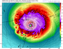
12Z HWRF has it at 941 in approach to Jamaica and 953 at approach to Cayman. That is extremely different than GFS, but I'm an HWRF fan so I can buy in to the possibility until I see something different. So far HWRF has performed much better than other models on this storm.
View attachment 148243View attachment 148244
12z HWRF is on the northern edge of the NHC cone but half the storm stays over water as it barely threads the needle of the peninsula. HWRF continues to flirt with a more northerly pass of the peninsula with a 945 on approach and 947 as it comes ashore. A more northerly pass would possibly put the US back in play.Looks like some shear but Beryl is such a beast it has little effect.
Sent from my iPhone using Tapatalk

Not sure I'm on board with this. GFS has it hitting the islands at 970 while in reality its hitting at 946 at the moment and may go lower. Will be interested to see what happens to the forecast when they build in reality.

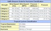
Might not be a plane out there but seeing the earlier pressure falls winds already at 150mph and an even better satellite presentation it's hard to argue against this potentially being a cat 5Just wow
View attachment 148247
Too bad recon isn't currently out there. Seems like this always happens as RECON departs. That just screams we have a Cat 5.Just wow
View attachment 148247
Just wow
View attachment 148247
The NOAA Hurricane Hunters are scheduled to investigate Beryl again
this evening.

The planes almost there so we will get a look soon at intensity
