GeorgiaGirl
Member
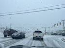
Idk if I'd say this is an inch of snow, but some areas have MUCH better coverage than I would've anticipated with how we had started.
Sinking air from the 2 main areas of precip caused by rising air motion.Someone explain to me like I’m a 5 year old why there’s a big swatch thru the middle of NC with No precipitation and it’s getting worse not better? Without saying dry slot lol
We are the rotor in the middle of two spinning helicopter bladesSomeone explain to me like I’m a 5 year old why there’s a big swatch thru the middle of NC with No precipitation and it’s getting worse not better? Without saying dry slot lol
18z 3km NAM crushes RDU:
View attachment 192743
12km NAM more or less agrees.
View attachment 192745
It ain't over yet, folks.
Looks like it has the coastal saving the day. Will it happen? I don't know, but I doubt Raleigh gets blanked, either. I wouldn't expect 6-8", though.
Goose feather band. It’s so much snow. Making a run at 6View attachment 192764
I guess it got it right here, though. Just sucks that the globals and NAM are useless when it comes to specifics and you can only halfway depend on the HRRR and 3K NAM maybe 12 hours out. But even now the current 3K NAM run just showed this, and it's nowhere close to what's going to happen here.To be fair, the HRRR is swinging wildly all over the place, too, and yet people post it a lot during the storm. According to it last night, I should be blanked but it's been pouring snow here for two hours.

@GaWx It wasn't supposed to be this cold right now correct? Getting some real flurries now close to the river.


Lets get these temps down and overperformIt just stated snowing here in midtown.
Yes, it’s been much colder than models.
I’m right there with ya. I’ve held a steady rate for the past 2 hours now but the flakes keep switching between decently sized and very tiny - and knowing how close I am to the edge of glory right now has me nervous but I just gotta let it ride and see how far we can hold on here in DurhamTalk about riding the line! LolView attachment 192763
At this point, just believe what you see out your window.Wow, hard to believe as I am watching the western flank continuing to pivot west of Raleigh and the eastern flank going nowhere.
Man It looks like 5 30 to 8, but northern wake county up, its light sauce till 9. Really really hate this for yall. I expected less accums, but light qpf, not 0 flakage. Just no lift in a 40 mile wide stretch /transfer zone. Like you getting subsidence from both sidesWhen is the snow shield over me going to be deactivated?
Same here. We just gotta hope we can hold on to this a lot of the afternoon, and then catch the coastal later. Not sure that's particularly likely, but eh...I’m right there with ya. I’ve held a steady rate for the past 2 hours now but the flakes keep switching between decently sized and very tiny - and knowing how close I am to the edge of glory right now has me nervous but I just gotta let it ride and see how far we can hold on here in Durham


LOL, I know that intersection. I used to live right there (now I am 5-10 mins away across I-40 in NE Chapel Hill). That's impressive since that tower is certainly within a mile of that location.From this location in Durham there is a tall tower in front of me. Can’t even see the tower a mile away.
Winds are starting to kick up a bit too. And when it does, you can't see 100 yards in front of you! I thought we might get a couple hours of heavy snow here, but I never imagined it would be like this during the middle of the day
The approaching trough and deep-layer cold air from the west is a ton meeting resistance from the warm advection being supplied by the mesolow over Columbia SC right now. This leads to insane low level frontogenesis and convergence over the Western Piedmont of Nc.
The end result of this “war” between these 2 clashing air masses with additional deep-layer support for ascent from the trough, is an insane “death” band of extremely heavy snow
I’m happy I get to live vicariously through everyone here that’s getting to witness this all-time snow event in the SW Piedmont & Charlotte
View attachment 192758
View attachment 192760
View attachment 192761
View attachment 192762
Suppose no chance this moves a bit east? Cause this borderline feels personal at this point in CNCThe approaching trough and deep-layer cold air from the west is a ton meeting resistance from the warm advection being supplied by the mesolow over Columbia SC right now. This leads to insane low level frontogenesis and convergence over the Western Piedmont of Nc.
The end result of this “war” between these 2 clashing air masses with additional deep-layer support for ascent from the trough, is an insane “death” band of extremely heavy snow
I’m happy I get to live vicariously through everyone here that’s getting to witness this all-time snow event in the SW Piedmont & Charlotte
View attachment 192758
View attachment 192760
View attachment 192761
View attachment 192762