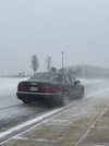
It’s the real deal in Charlotte folks
Biggun
Biggun
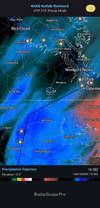
Idk it's gonna be so close. It's been slowly building west, looks like Scotland Neck into the good stuff now but westward movement has almost stalled. 95 might be as close as it gets@RBR71 ripping pretty decent here in Roanoke Rapids with that little band, do you think the heavier bands make it this far?
Are we a 10 on the snow meter now?
Most of us in the triangle and NE of there had given up hope!! So glad the afternoon has turned things around for us.Legit snow now and decent rates, ground turning white. I had give up hope


If this is true we’re going to be pushing 15-16” in southern Rowan County. Storm of a lifetime!!


 . I’m 34…
OMG it’s pouring snow. We have to be over an inch.

I’m sorry but I don’t believe that for a second. We’ve had 15 minutes of flurries and besides that, zip3k NAM really beefs up the totals for central NC
I’m over an inch now and still moderate snow
Snow flurries stopped in N Harnett County...dry slot still looms.
Reporting from the dry slot: Was able to get under an arm of the good precip band to the west. Light snow right now is effectively accumulating on everything (pavement white). Looks like I'll fall back out of the precip in the next few minutes.

I get it but I would wait to see what the coastal does this evening before I pass judgementI’m sorry but I don’t believe that for a second. We’ve had 15 minutes of flurries and besides that, zip
It’s stacking up fast now!Heaviest I’ve seen all day in Charlotte with chicken feather sized flakes.


Where you at in Charlotte?I’m not even sure if there is a word to describe how hard it is snowing right now. This is incredible.
GSP tweeted a few minutes, additional 6-8" for the CLT metro
Even I'm having a hard time fathoming this