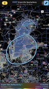
I am watching that too - it should be here shortlyThat verga band over moving into NE GA (Soon to be enter Upstate SC) should help a ton with getting the DGZ moist. I think we're less than a couple hours away potentially from snow reaching SFC.
-
Hello, please take a minute to check out our awesome content, contributed by the wonderful members of our community. We hope you'll add your own thoughts and opinions by making a free account!
You are using an out of date browser. It may not display this or other websites correctly.
You should upgrade or use an alternative browser.
You should upgrade or use an alternative browser.
Wintry Machine Learning Mauler 1/30-2/1
- Thread starter SD
- Start date
WxBlue
Meteorologist
This is essentially a slightly less resolution version of my forecast map. Very nice!Here's what everyone is waiting for.
View attachment 192248
I fear I'm just about 7-10 miles too SE of this band hitting northern most Durham country right now :\Big Flakes in North Durham. Starting to cover everything.
Weatherheels
Member
Flurries started last 10 minutes, about 7 miles NW of PTI
LukeBarrette
im north of 90% of people on here so yeah
Meteorology Student
Member
2024 Supporter
2017-2023 Supporter
So the banding is going nuts
iwantsouthernsnow123
Member
Yep, initally it wont bring anything to the surface, but the DGZ is getting very moist, just a matter of time. I suspect by around midnight we should start seeing it reach the surface around this area.I am watching that too - it should be here shortly
One thing that will be very interesting after we know exactly how much of a snow pack we have, is how low temperatures could go overnight on Sunday. The 0z GFS now has me with a low of 3 on Monday morning.
Milky moonlight still. But it won't be long.can anyone in this area lmk if any of that is actually reaching the ground? i’d assume not with no mping reports but you never know. looks pretty beefy for this early on
View attachment 192249
The models aren’t as reliable for a storm like this. Observations are actually useful in this thread.Which is probably why this storm needs an obs thread? Can we not just enjoy this storm without too much thought into what goes where, maybe
If you’ve got an observation, ya shouldn’t hesitate to post it for fear of getting banned from the thread. Maybe just don’t post 5+ redundant photos of your kids and/or dog playing in the snow (ok, one redundant dog photo is always fine).
It’s hard to imagine it was around 53 at 4pm here today and 7hrs later it’s 36. We dropped 5 degrees within the past hour alone. I’ve transitioned into radar mode. The seesawing back and forth for my area on model guidance is giving me a headache. Hoping for the best, but prepared for nothing at the same time.
iwantsouthernsnow123
Member
Appears like there may be some snow flurries in Sky Valley GA based off webcamera's available online. Very light and occasional but that will increase.
(Quality of the webcam is horrible so you may have to wait a while to see a flake as you have to look very closely)
(Quality of the webcam is horrible so you may have to wait a while to see a flake as you have to look very closely)
Avalanche
Member
Dang GFS burys the whole stateHere's what everyone is waiting for.
View attachment 192248
disassociated_vort
Member
Sctvman
Member
Channel 4 going 1-3 CHS metro, 3-5 northern part of Berkeley/Charleston, T-1 south. Channel 2 2-4” metro, 3-6 northern part, t-2 south, 4-8 in Kingstree and northern Georgetown County.
That Charleston metro cutoff could be crazy. Edisto could be at a dusting or maybe a little over while Moncks Corner could be 4-6”
That Charleston metro cutoff could be crazy. Edisto could be at a dusting or maybe a little over while Moncks Corner could be 4-6”
JimBobs
Member
- Joined
- Jan 2, 2017
- Messages
- 1,566
- Reaction score
- 4,279
Yea im waiting and steadily checking my camera. Prob gonna take a nap and get up at 2...good luck!Appears like there may be some snow flurries in Sky Valley GA based off webcamera's available online. Very light and occasional but that will increase.
(Quality of the webcam is horrible so you may have to wait a while to see a flake as you have to look very closely)
WxBlue
Meteorologist
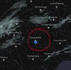
Forcing isn't there yet and won't be for several more hours.Feels like it's already snowing in every direction except CLT. Charlotte snow-View attachment 192254hole forcefield activated.
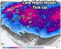
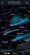
Uptick for Raleigh? Not so sure about that.CJ says “en route”View attachment 192253
@Parker fighting for his life up there
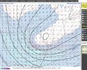
Both NAMs didn't have it closing off until 8z. Closed off at 4z
DylanWx
Member
Seems like a bit more moisture on radar than modeled? Thoughts?
Stormsfury
Member
Been many a model Showing Lowcountry Tri-County enhancement happening. I feel like 4"-6" is a good estimate on what I believe will occur, maybe isolated higher and lower spots.Channel 4 going 1-3 CHS metro, 3-5 northern part of Berkeley/Charleston, T-1 south. Channel 2 2-4” metro, 3-6 northern part, t-2 south, 4-8 in Kingstree and northern Georgetown County.
That Charleston metro cutoff could be crazy. Edisto could be at a dusting or maybe a little over while Moncks Corner could be 4-6”
Currently in Sautee Nacoochee, GA, 3 miles east of Helen. Flakes are finally reaching the ground. Should be headed your way shortly Athens-area folks!
Got a little bit coming down now in NW Winston Salem.... seeing it on top of the grill cover
Sent from my Pixel 10 Pro XL using Tapatalk
Sent from my Pixel 10 Pro XL using Tapatalk
disassociated_vort
Member
Dunkman
Member
Some flurries here in north High Point. Let’s bring this one home!
So what does that translate too??Both NAMs didn't have it closing off until 8z. Closed off at 4z
Yeah, I've seen some very light flurries falling; but no real flakes. It's definitely hanging on the edge.Got a little bit coming down now in NW Winston Salem.... seeing it on top of the grill cover
Sent from my Pixel 10 Pro XL using Tapatalk
I hate to call this the official start but I guess a gaggle of flurries counts as that.
So I'll go make a drink to celebrate.
Makeitsnow
Member
if you look really close on satellite you can see the 925mb spin already just south of lake lanier
WxBlue
Meteorologist
StormSurf
Member
Other than a light snow shower earlier today, and flurries around 5pm, Roanoke is blanked so far.
iwantsouthernsnow123
Member
Didnt quit make it into Mizzou. The base of tpv trough did. Thats a small tick east of the models ive been looking at. Be interesting to see if it has any down hill affects.
Yeah nothing here in NE CH. I am afraid I’m going to be too far south for this and too far north for the best stuff tomorrow!I fear I'm just about 7-10 miles too SE of this band hitting northern most Durham country right now :\

