-
Hello, please take a minute to check out our awesome content, contributed by the wonderful members of our community. We hope you'll add your own thoughts and opinions by making a free account!
You are using an out of date browser. It may not display this or other websites correctly.
You should upgrade or use an alternative browser.
You should upgrade or use an alternative browser.
Wintry Machine Learning Mauler 1/30-2/1
- Thread starter SD
- Start date
I personally like the look of the RGEM at 500. The track and tilt, will show more qpf in future runs imo.RGEM cross between the NAM and the FV…
BrickTamland
Member
Now that was ICONic.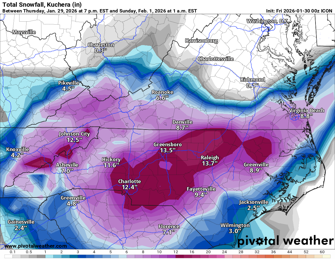
Absolutely smoked
Yeah rates looked awfully light for a 980s MSLP low riding that baroclinic zone over the gulf streamI personally like the look of the RGEM at 500. The track and tilt, will show more qpf in future runs imo.
To me it makes sense for the low to pop somewhere between CHS to ILM. I mentioned it this morning but there is a very sharp change in SSTs in that area that can create a natural baroclinic zoneOn hr 48, it actually popped a new low east of Charleston after having one further north off ILM. Cyclonically looped.
")
Tsappfrog20
Member
Allan Huffman says he is keeping his map as is tonight and will maybe make some tweaks tomorrow said may increase in GA and make some narrow adjustments in NC.
Sent from my iPhone using Tapatalk
Sent from my iPhone using Tapatalk
Well @WeatherNC has been saying it, slp closer to the coast, almost instant occlusion and watch precip explode. He's done these things a time or two before and models seem to be heading in that direction. QPF steadily increasing and backing w/nw, never underestimate a bombing lp right along the Gulf Stream. We might not be done
Murphy to Manteo.......Goals!Well @WeatherNC has been saying it, slp closer to the coast, almost instant occlusion and watch precip explode. He's done these things a time or two before and models seem to be heading in that direction. QPF steadily increasing and backing w/nw, never underestimate a bombing lp right along the Gulf Stream. We might not be done
Agreed and Finally see some models tick NW…hopefully it doesn’t tick back eastI personally like the look of the RGEM at 500. The track and tilt, will show more qpf in future runs imo.


NBMv4 has these models/weights:Super confused by this as well. I would expect the National Blend of Models to more or less reflect the models I see, but it often doesn’t seem to. Also, what is the difference between the NBM and the Parallel NBM?
NBMv5 (parallel) is a bit different but the weights haven't been released. Pretty sure they removed SREF and added AI Models (like AIFS). They also do some different bias correction methods in v5 such as probability matched mean to achieve more accurate/unsmoothed outputs.

Brad’s up to a 7!
- Joined
- Jan 23, 2021
- Messages
- 4,604
- Reaction score
- 15,203
- Location
- Lebanon Township, Durham County NC
Cumulative BUFKIT ratio for NAM: 20:1!
NBAcentel
Member
pretty classic and straightforward evolution here on the rgem, intial WAA band around FAY/RAH, then the backside deformation band develops in the upstate/Piedmont into CNC in WPC mentioned fashion, which moves east/SE 
Brad’s up to a 7!
Brad only 3-6” for CLT metro
I’d be double that.
Looks like Winter Weather Advisories might be needed in *checks notes* Tampa. 
iwantsouthernsnow123
Member
A lot of areas on the graphic just doesn't quite seem right.Brad only 3-6” for CLT metro
I’d be double that.
Sctvman
Member
That would be the story of the entire stormLooks like Winter Weather Advisories might be needed in *checks notes* Tampa. View attachment 191547
RGEM not terribly far off AIFS/WxN precip shield
RGEM at hr42 here

Here is the Charlotte sounding at that time. 19 degrees at the surface with a DEEP Dendrite Growth Zone from 925mb up to 680mb

On top of that, there's mid-level frontogenesis going on here in the purple at 850mb. When air parcels collide in the mid-levels, they must rise!. The frontogenesis being co-located within the Dendrite Growth Zone - we don't see that crap around here - that's what happens in New England. Typically, we have fronto in the 850 to 700mb layers, but our DGZone is up near 600 - 500mb. Potential here!

Here is the Charlotte sounding at that time. 19 degrees at the surface with a DEEP Dendrite Growth Zone from 925mb up to 680mb
On top of that, there's mid-level frontogenesis going on here in the purple at 850mb. When air parcels collide in the mid-levels, they must rise!. The frontogenesis being co-located within the Dendrite Growth Zone - we don't see that crap around here - that's what happens in New England. Typically, we have fronto in the 850 to 700mb layers, but our DGZone is up near 600 - 500mb. Potential here!
Six Mile Wx
Member
And when the Nam lines up with the Euro, that’s what we’re getting.I’m just a guy but NAM looked like an early nod toward the EURO at the surface
Well @WeatherNC has been saying it, slp closer to the coast, almost instant occlusion and watch precip explode. He's done these things a time or two before and models seem to be heading in that direction. QPF steadily increasing and backing w/nw, never underestimate a bombing lp right along the Gulf Stream. We might not be done
Taking the 0z RDPS surface reflection at face value, it bounces around initially but in general it's parked in roughly the same spot due east of Cape Lookout at hrs 42 and 60, during that time it drops 34mb. That's almost unheard of at our latitude.
Granted the northern Mid-Atlantic and southern New England get some orapgfrhic enhancement as you head inland but still, Winchester/Front Royal are often jackpots for big MA bombs, similar are the Catskills for bombs which affect southern New England.
I'd expect a continued uptick in QPF associated with the coastal, somewhere in the 1.4" imo seems reasonable top end for areas fortunate to get under the best 700mb fronto, right now that looks like the southern Coastal Plain, Duplin/Wayne/Sampson. 1" amounts should be fairly common east of 95 and south of 64, possibly down to Lumberton and Florence, then east to ILM.
Last edited:
I have noticed in the past, just like with the northwest trend, models start seeing better the surface features of these bombing lows, which consolidates the precip more heavily to the northwest of low pressure systems, “filling it in” just like we are seeing with the NAM and ICONWhat’s the analysis outside of the hunch?
Stormsfury
Member
Almost like we're setting up some kind of TROWAL or something?RGEM at hr42 here
View attachment 191549
Here is the Charlotte sounding at that time. 19 degrees at the surface with a DEEP Dendrite Growth Zone from 925mb up to 680mb
View attachment 191550
On top of that, there's mid-level frontogenesis going on here in the purple at 850mb. When air parcels collide in the mid-levels, they must rise!. The frontogenesis being co-located within the Dendrite Growth Zone - we don't see that crap around here - that's what happens in New England. Typically, we have fronto in the 850 to 700mb layers, but our DGZone is up near 600 - 500mb. Potential here!
View attachment 191551
WxBlue
Meteorologist
Yup, this is another reason why I kept saying this is very New Hampshire-like snowstorm with epic forcing, deep cold, and borderline blizzard conditions with the wind (plus actual blizzard in the OBX). Up north, we're usually looking for two bandings of FGEN at 850 and 700.RGEM at hr42 here
View attachment 191549
Here is the Charlotte sounding at that time. 19 degrees at the surface with a DEEP Dendrite Growth Zone from 925mb up to 680mb
View attachment 191550
On top of that, there's mid-level frontogenesis going on here in the purple at 850mb. When air parcels collide in the mid-levels, they must rise!. The frontogenesis being co-located within the Dendrite Growth Zone - we don't see that crap around here - that's what happens in New England. Typically, we have fronto in the 850 to 700mb layers, but our DGZone is up near 600 - 500mb. Potential here!
View attachment 191551
Cary_Snow95
Member

wow
Member
Qpf expanding both west and east

Winchester up into the Catoctins and northern MD always jack in those MA bombs while DC gets a minima. Famous dform band there with a little orographic enhancementTaking the 0z RDPS surface reflection at face value, it bounces around initially but in general it's parked in roughly the same spot due east of Cape Lookout at hrs 42 and 60, during that time it drops 34mb. That's almost unheard of at our latitude.
Granted the northern Mid-Atlantic and southern New England get some orapgfrhic enhancement as you head inland but still, Winchester/Front Royal are often jackpots for big MA bombs, similar are the Catskills for bombs which affect southern New England.
I'd expect a continued uptick in QPF associated with the coastal, somewhere in the 1.4-1.7" imo seems reasonable top end for areas fortunate to get under the best 700mb fronto, right now that looks like the southern Coastal Plain, Duplin/Wayne/Sampson. 1" amounts should be fairly common east of 95 and south of 64, possibly down to Lumberton and Florence, then east to ILM.
Crow
Member
Looks identical to last nights 00z run at the same time
AIGFS increased once again for ATL! WOW!
At around 0.25" QPF for north ATL. That's 5" at a 20:1 ratio.

At around 0.25" QPF for north ATL. That's 5" at a 20:1 ratio.
It's STILL doing this?! Either this model is on to something, or this model needs some more machine learning.AIGFS increased once again for ATL! WOW!
At around 0.25" QPF for north ATL. That's 5" at a 20:1 ratio.
View attachment 191554
Everyone NE of I 26 and N of I 20 with 6”+. Would love it
Cary_Snow95
Member
AIGFS increased precip over central nc

ducketta27
Member
So, weird.... but the Kuchera value for Augusta is actually lower than the 10:1 ratio here... 10:1 shows 2.7 for AGS while Kuchera is half an inch less... shouldn't ratios be higher for this event (even in AGS)?
mx3gsr92
Member
The NW trend a day out never fails.

Gfs,FV3 and Icon in lock step
GFS on WBell

Once again, the GFS is further NE with the 500MB UUL as it's about to enter Georgia. Note the tilt is better on the AIGFS, too. It will be interesting to see which is right.
