Webberweather53
Meteorologist
Yeah I am not surprised. 2 areas of forcing competing against each other


NAM rakes the coastal plain with that deform band as the coastal bombs. Makes sense WXnext has been showing this for a whileI fully expect NC to fill in more. Than deform band east of 95 is a gorgeous at 57

Some similarities. Looks completely different for far Western NC, however.


Yeah the moisture feed is just off there was some positive aspects as far as the H5 look but agreed don't think anyone in Carolina should worry about it's qpf output it will be more then thatThe NAM with a totally, completely different solution than the SREF should give anyone pause when considering the two.

This seems to as well came further West with initial bands of precip and as others mentioned as long as the H5 cooperates that the N and Western sides will see decent more expansive windows of moisture it's good to see alot of models retro some back to pushing moisture further westFV3 with the band of love just east of me, around Athens. Still going in some areas east.
View attachment 191187
That final band as it clears the mountains and pushes into the upstate and the piedmont could really drop an additional inch or 2 as it builds.I have no faith in this model, but the FV3 is pretty legit. Here' the last frame and snow totals up to that point.
View attachment 191172
NAM closes it at 850
Yeah, that completely throws the SFC features completely off and why the coastal isnt properly feeding back inland like we would think given the 500mb low placement.View attachment 191172
NAM closes it at 850 and makes it warm core. subtropical storm andrea. like man i just don't think this happens
That final band as it clears the mountains and pushes into the upstate and the piedmont could really drop an additional inch or 2 as it builds.

Well, eh. But it is still -12 to -18.
700mb upper level winds out of the south, quite a bit of warm air advection
Sent from my iPhone using Tapatalk


Yes, the CMC has barely budged for 2 & a half days I believe.RGEM been holding steady for days and now 6z Euro/GFS and now the NAM moderate a little more to a Western pivot not yet quite to the RGEM but time to expand that way maybe RGEM/CMC will get the GOAT for the weekend?


Well, you can see the dryslot between the ULL and Coastal more.The rgem seems to be hold serve so far
Sent from my iPhone using Tapatalk

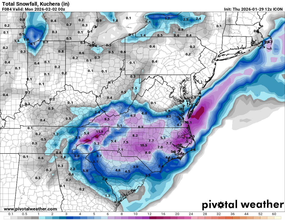
Big time uptick from the prior runs for central NC, except CLT who seems like is going to win this one, regardless.Icon totals
Yeah that’s going to be nasty (in a bad way) wherever that sets up shop.Well, you can see the dryslot between the ULL and Coastal more.


Yes. Several analog storms with this setup produced these types of dry slots too. Check out what @Webberweather53 has be posting about it recently.So is a model consensus building there will be a "dry slot" somewhere in this event? At least on the short range ones which would depict it more than the globals?

