• Hello, please take a minute to check out our awesome content, contributed by the wonderful members of our community. We hope you'll add your own thoughts and opinions by making a free account!

Wintry Machine Learning Mauler 1/30-2/1

There is a pretty good amount of low to mid level warm advection on the euro over eastern NC as the low cranks up. Probably underestimating that as usual (& arguably too dry)
The euro has a tendency (at least historically) of being too dry in these sort of events if memory serves. January 3-4, 2018 comes to mind strongly.

Granted, that was many model updates ago.
 
Curious if you think the ~18-20:1 ratios the Kuchera is banking on are realistic? I'm just always a little hesitant to bank on crazy ratios around here no matter how cold it is.

I know it's happened before where ratios were truly phenomenal (January 2003 being the biggest one I can think of - supposedly, ratios were 30-40:1 in some areas of the southern NC foothills), but it is a rarity.

I think the 15-20:1 ratios are possible here given how cold the air mass that will be in place is
 
I definitely think the euro and the ai models are trending much worse for western Carolina’s. Eastern Carolina’s going to get smoked


Sent from my iPhone using Tapatalk
There's literally nothing out there to support this at all. Please stop saying things that aren't true.
 
New Precip map from the NWS looks legit!
WPCQPF168_SFC-Day1-7.png
 
Is it safe to assume the ratios will decrease closer to the coast?
You can say that, however, even then, ratios should be higher than normal. Typically, snows in Coastal SC are in the 6 to 8:1 ratio range. Well, EDIT to include CHS key message, unusually high ratios up to 20:1 could occur locally. Whoa.

Guidance indicates that strong H5 low will cut-off early Saturday
over the Mid-West, swinging over the Southeast U.S. Saturday night.
At the sfc, low pressure should develop off the Southeast coast
early Saturday, deepening off Carolina coast on Saturday, then
tracking NE Saturday night. As the sfc low strengthens, a
deformation zones should develop across the forecast area Saturday
morning through Saturday. The peak period of forcing should occur
with the approach and passage of the deep H5 closed low Saturday
night. Forecast soundings indicate that conditions across the CWA
will start dry Saturday morning, resulting in very little QPF.
However, moisture should increase through the day into Saturday
night, enough to generate 0.01-0.05" per 6hrs. Forecast soundings
indicates that measurable precipitation may begin as a mix of rain
and snow over the interior counties Saturday morning, then snow
Saturday afternoon. Snow should remain until the passage of the H5
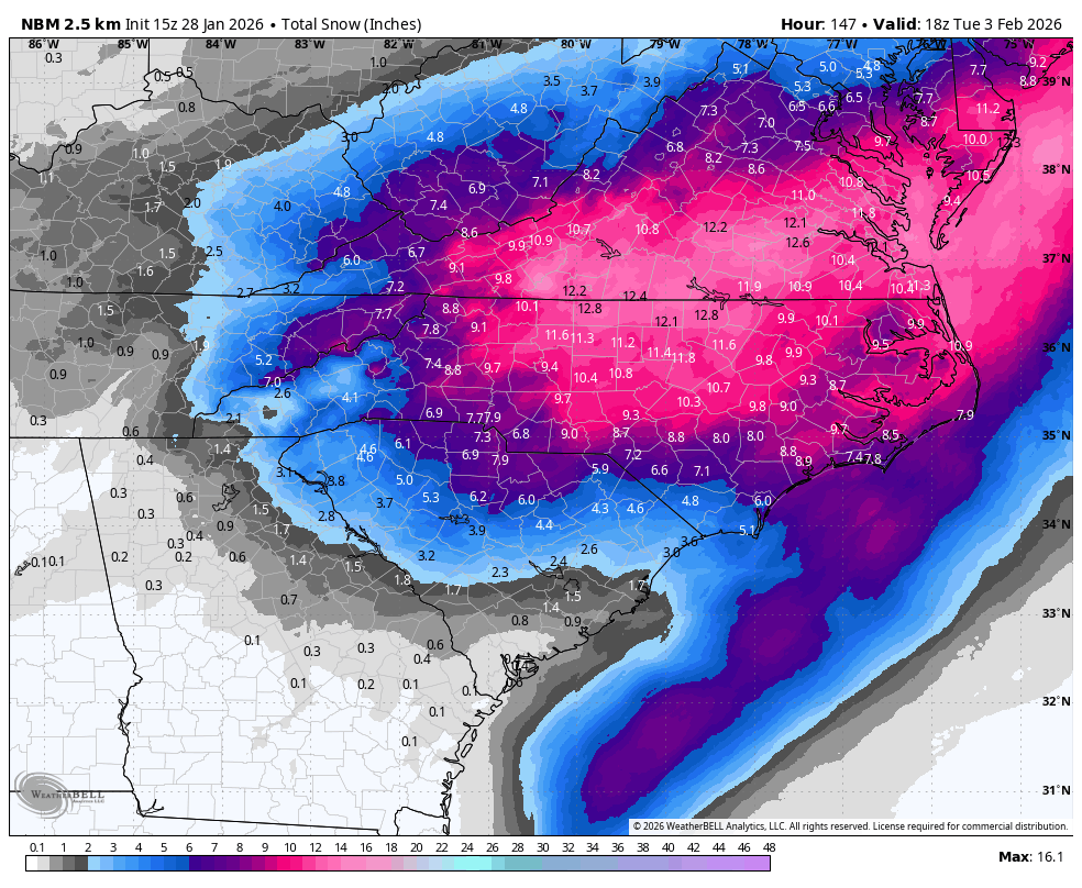
low Sunday morning. Given the cold temperatures, snow ratio could
approach 20 to 1 Saturday night, which is quite high for our region,
resulting in period of "dry" snowfall. This quality of snow may make
reaching warning criteria snowfall, 2 inches, possible over inland
Berkeley and Dorchester Counties. Advisory level snow, 1 to 2
inches, is possible across the CHS Tri-county and inland SC and GA
counties.
 
You can say that, however, even then, ratios should be higher than normal. Typically, snows in Coastal SC are in the 6 to 8:1 ratio range.
Is that due to the drought as well as the cold air? I am definitely pleasantly surprised that our rates could be 20:1. The ceiling seems to be a little higher than I thought for us.
 
5" in 2 hours I meant.

260131/0700Z 67 05007KT 26.7F 0:1| 0.0|| 0.00|| 0.00|| 0.000 0:1| 0.0|| 0.00|| 0.00|| 0.00 0| 0| 0
260131/0800Z 68 04007KT 26.0F SNOW 12:1| 0.1|| 0.00|| 0.00|| 0.007 12:1| 0.1|| 0.00|| 0.00|| 0.01 100| 0| 0
260131/0900Z 69 04008KT 25.6F SNOW 14:1| 0.2|| 0.00|| 0.00|| 0.016 14:1| 0.3|| 0.00|| 0.00|| 0.02 100| 0| 0
260131/1000Z 70 04009KT 25.4F SNOW 11:1| 0.2|| 0.00|| 0.00|| 0.022 12:1| 0.5|| 0.00|| 0.00|| 0.04 100| 0| 0
260131/1100Z 71 04009KT 25.1F SNOW 13:1| 0.3|| 0.00|| 0.00|| 0.024 12:1| 0.9|| 0.00|| 0.00|| 0.07 100| 0| 0
260131/1200Z 72 04009KT 24.5F SNOW 14:1| 0.4|| 0.00|| 0.00|| 0.031 13:1| 1.3|| 0.00|| 0.00|| 0.10 100| 0| 0
----------------------------------------------+----++-----+-------------++--------------++-------------++-----------+---+---
260131/1300Z 73 04009KT 24.2F SNOW 10:1| 0.3|| 0.00|| 0.00|| 0.030 12:1| 1.6|| 0.00|| 0.00|| 0.13 100| 0| 0
260131/1400Z 74 03009KT 24.0F SNOW 14:1| 0.5|| 0.00|| 0.00|| 0.035 12:1| 2.1|| 0.00|| 0.00|| 0.17 100| 0| 0
260131/1500Z 75 04010KT 23.3F SNOW 5:1| 0.3|| 0.00|| 0.00|| 0.057 11:1| 2.4|| 0.00|| 0.00|| 0.22 100| 0| 0
260131/1600Z 76 03011KT 23.6F SNOW 6:1| 0.1|| 0.00|| 0.00|| 0.020 10:1| 2.5|| 0.00|| 0.00|| 0.24 100| 0| 0
260131/1700Z 77 03011KT 24.5F SNOW 23:1| 0.6|| 0.00|| 0.00|| 0.026 11:1| 3.1|| 0.00|| 0.00|| 0.27 100| 0| 0
260131/1800Z 78 03010KT 23.3F SNOW 10:1| 1.0|| 0.00|| 0.00|| 0.096 11:1| 4.0|| 0.00|| 0.00|| 0.36 100| 0| 0
----------------------------------------------+----++-----+-------------++--------------++-------------++-----------+---+---
260131/1900Z 79 03011KT 23.6F SNOW 10:1| 0.4|| 0.00|| 0.00|| 0.040 11:1| 4.4|| 0.00|| 0.00|| 0.40 100| 0| 0
260131/2000Z 80 02009KT 23.4F SNOW 16:1| 0.5|| 0.00|| 0.00|| 0.033 11:1| 5.0|| 0.00|| 0.00|| 0.44 100| 0| 0
260131/2100Z 81 02010KT 22.4F SNOW 19:1| 1.3|| 0.00|| 0.00|| 0.069 12:1| 6.3|| 0.00|| 0.00|| 0.51 100| 0| 0
260131/2200Z 82 02013KT 21.1F SNOW 10:1| 0.4|| 0.00|| 0.00|| 0.043 12:1| 6.8|| 0.00|| 0.00|| 0.55 100| 0| 0
260131/2300Z 83 02013KT 19.5F SNOW 15:1| 0.3|| 0.00|| 0.00|| 0.022 12:1| 7.1|| 0.00|| 0.00|| 0.57 100| 0| 0
260201/0000Z 84 01014KT 18.9F SNOW 18:1| 0.8|| 0.00|| 0.00|| 0.044 13:1| 7.9|| 0.00|| 0.00|| 0.62 100| 0| 0
----------------------------------------------+----++-----+-------------++--------------++-------------++-----------+---+---
260201/0100Z 85 01014KT 18.0F SNOW 16:1| 1.1|| 0.00|| 0.00|| 0.068 13:1| 9.0|| 0.00|| 0.00|| 0.68 100| 0| 0
260201/0200Z 86 01013KT 17.7F SNOW 11:1| 0.8|| 0.00|| 0.00|| 0.069 13:1| 9.7|| 0.00|| 0.00|| 0.75 100| 0| 0
260201/0300Z 87 01012KT 17.7F SNOW 24:1| 1.5|| 0.00|| 0.00|| 0.064 14:1| 11.3|| 0.00|| 0.00|| 0.82 100| 0| 0
260201/0400Z 88 36015KT 17.5F SNOW 29:1| 3.7|| 0.00|| 0.00|| 0.127 16:1| 15.0|| 0.00|| 0.00|| 0.94 100| 0| 0
260201/0500Z 89 36015KT 17.9F SNOW 17:1| 2.4|| 0.00|| 0.00|| 0.141 16:1| 17.4|| 0.00|| 0.00|| 1.08 100| 0| 0
260201/0600Z 90 35015KT 18.2F SNOW 9:1| 0.6|| 0.00|| 0.00|| 0.060 16:1| 17.9|| 0.00|| 0.00|| 1.14 100| 0| 0
----------------------------------------------+----++-----+-------------++--------------++-------------++-----------+---+---
260201/0700Z 91 35015KT 18.2F SNOW 17:1| 1.0|| 0.00|| 0.00|| 0.060 16:1| 19.0|| 0.00|| 0.00|| 1.20 100| 0| 0
260201/0800Z 92 34014KT 18.8F SNOW 16:1| 1.1|| 0.00|| 0.00|| 0.069 16:1| 20.1|| 0.00|| 0.00|| 1.27 100| 0| 0
260201/0900Z 93 32013KT 18.8F SNOW 19:1| 1.2|| 0.00|| 0.00|| 0.061 16:1| 21.3|| 0.00|| 0.00|| 1.33 100| 0| 0
260201/1000Z 94 32014KT 16.8F SNOW 23:1| 1.4|| 0.00|| 0.00|| 0.060 16:1| 22.6|| 0.00|| 0.00|| 1.39 100| 0| 0
260201/1100Z 95 32013KT 16.6F SNOW 23:1| 0.8|| 0.00|| 0.00|| 0.034 16:1| 23.4|| 0.00|| 0.00|| 1.43 100| 0| 0
260201/1200Z 96 32012KT 17.1F SNOW 12:1| 0.3|| 0.00|| 0.00|| 0.024 16:1| 23.7|| 0.00|| 0.00|| 1.45 100| 0| 0
 
New Precip map from the NWS looks legit!
WPCQPF168_SFC-Day1-7.png
This is an insane forecast when you account for ratios. Implies GSO and RDU are easily looking at excess of a foot and RDU is approaching January 2000 totals.
 
This is an insane forecast when you account for ratios. Implies GSO and RDU are easily looking at excess of a foot and RDU is approaching January 2000 totals.

Thing to keep in mind is it says 7 day total precip. Are they expecting precip next week?


Sent from my iPhone using Tapatalk
 
Is that due to the drought as well as the cold air? I am definitely pleasantly surprised that our rates could be 20:1. The ceiling seems to be a little higher than I thought for us.
The depth of the cold air is the reason for higher ratios than normal. Our typical snows are more a heavier wet variety as temps are barely below freezing (and usually higher precipitable water values). This go around, the very deep cold air at all levels makes it possible for better dendritic growth, increasing ratios.
 
People need to stop living and dying by every run. ULL are going to jump around all the way up to the start of the event. Honestly I’m only looking at 500mb maps until we get to CAMs range.
Great point! The only reason to live and die by every run is if you are on some sort of weather message board where people enjoy breaking those types of things down as a hobby. Oh wait ....
 
People need to stop living and dying by every run. ULL are going to jump around all the way up to the start of the event. Honestly I’m only looking at 500mb maps until we get to CAMs range.

Yep. Constantly drilled into our heads here at NCSU is “top down”. What’s meant by that? Focus on the synoptic scale and then funnel your way to the mesoscale. Too far out to determine mesoscale features but anywhere SE of I 85 in NC, 6+” is a very reasonable outcome
 
New National Blend of Models. It usually runs a cycle behind so we might see the totals trimmed a little for the next update.
1770141600-bhVFQZlUQEo.png
Might be the highest totals for Piedmont NC I've seen on the NBM this close to onset. Agreed it'll likely step back a bit, but it's beautiful to look at nevertheless.
 
Back
Top