Bah humbug.


| Model | Runtime | lead to start 7am Saturday | Kuchera snow | 10:1 Snow | Total liquid | Start time | end time | notes |
| Euro | 06z | 78hr | 4.6 | 2.8 | 0.28 | 5am Sat | 8pm Saturday | |
| Euro AI | 06z | 78hr | N/A | 3.8 | 0.4 | 1am Sat | 8pm Saturday | |
| GFS | 06z | 78hr | 5.2 | 4.5 | 0.47 | 8am Sat | 6pm Saturday | |
| GFS AI | 06z | 78hr | N/A | N/A | 0.47 | 7pm Friday | 9pm Saturday | |
| Rgem | 06z | 78hr | 3.2 | 2.8 | 0.28 | 4pm Friday | N/A | not finished, only through 1pm saturday |
| NAM | 06z | 78hr | 6.1 | 4.4 | 0.44 | 3am Saturday | N/A | not finished, only through 1pm saturday |
| ICON | 06z | 78hr | N/A | 1.4 | 0.19 | 8am Saturday | 3pm Saturday | |
| NAM | 12z | 72hr | 0.9 | 0.6 | 0.07 | 9am Saturday | 5pm Saturday | |
| Rgem | 12z | 72hr | 4.1 | 2.9 | 0.29 | 4am Saturday | N/A | not finished at 7pm saturday |
| ICON | 12z | 72hr | N/A | 1.7 | 0.19 | 5am Saturday | 5pm Saturday | |
| Euro | 12z | 72hr | 5 | 3.1 | 0.31 | 1am Saturday | 8pm Saturday | |
| Euro AI | 12z | 72hr | N/A | 3.3 | 0.34 | 1am Saturday | 7pm Saturday | |
| GFS AI | 12z | 72hr | N/A | N/A | 0.49 | 7pm Friday | 11pm Saturday | |
| GFS | 12z | 72hr | 4.6 | 3.8 | 0.35 | 8am Saturday | 11pm Saturday |


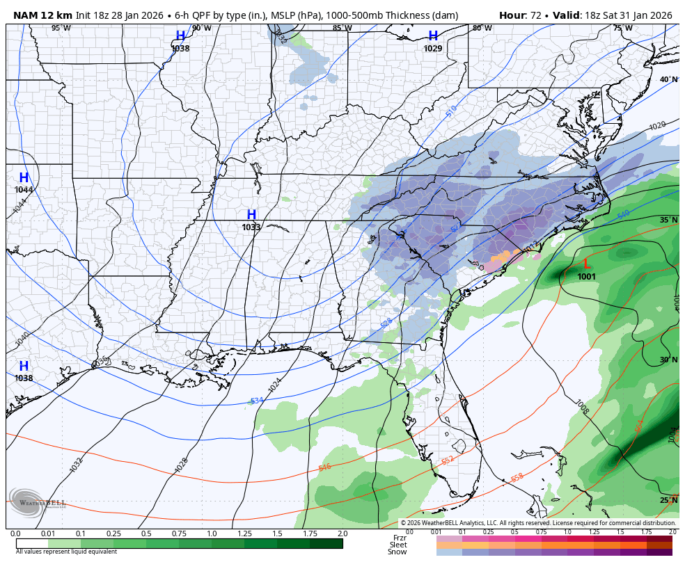
Might be some frontogenesis forcing. I’m not an expert on that though. Maybe someone else can chime in?I ain't too bright, but with a surface low racing off to the NW and the ULL long gone (not to mention it's hour 84 of the NAM) I'd be uber dubious about buying into westward building precip shields.
 Dropped a foot on me in Northeast Tennessee. Take my money. This is all I need.
You still thinking the leeside gets screwed?I ain't too bright, but with a surface low racing off to the NW and the ULL long gone (not to mention it's hour 84 of the NAM) I'd be uber dubious about buying into westward building precip shields.
Northeast Georgia??The southern s/w is really popping on the NAM.. that's going to spin up our sfc low quicker and see the precip shield really blossom over AR/TN/NC

 Rates and coverage would be even stronger and wider with that much WAA over the Upstate
This was the map I was referring to for @beanskip. Thanks for posting!View attachment 190764
View attachment 190765Rates and coverage would be even stronger and wider with that much WAA over the Upstate
Yeah that's the thing I liked the most....not just the high amounts, but the geographical footprint. That's what we want to hold. Of course GA / Bama / VA want it to slide their way....which is understandableCompare the 12z EPS v/s 18z NAM, assuming 10:1....right on top of each other. Not bad at all...
View attachment 190761
This is my concern tooYou still thinking the leeside gets screwed?
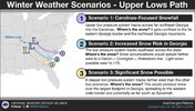
Looking at the models the past couple of days...CLT area has the best case of guaranteed snow with just the upper low.Yeah that's the thing I liked the most....not just the high amounts, but the geographical footprint. That's what we want to hold. Of course GA / Bama / VA want it to slide their way....which is understandable
 Would not be surprised to see A. a larger and longer last comma head or B. backfilling with this much FGEN WAA on the lee side of the mountains
View attachment 190766Would not be surprised to see A. a larger and longer last comma head or B. backfilling with this much FGEN WAA on the lee side of the mountains