• Hello, please take a minute to check out our awesome content, contributed by the wonderful members of our community. We hope you'll add your own thoughts and opinions by making a free account!

Wintry Machine Learning Mauler 1/30-2/1

The improvements in the ICON solution were apparent at 72 hours. I intended to post this at the time, but the wife happened.

Note the NE TPV retrograding to the NW from earlier runs, leaving breathing room for the Rockies SW to light off a GOM LP/Miller A.

Just a little more of this, and the whole board will be ecstatic. Too much more of this, and the Gulf states will be enjoying a rainstorm.

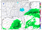
HUge changes over just the past two days.

pivotal-weather-icon-500hv-conus.gif
 
The ceiling is high even for western sections of the current precip shield I would think. The way models have this thing wrapping up and deepening. Keep that where it’s at and slow it down 6-12 hours and it’s a snow machine kind of look
Doesn't hurt to have -10 to -15C 850's either.
 
This was ICON from day 5-6 out for this past weekends event...it did fairly well.

View attachment 189472
It highest resolution of all physics models.
My mouth is watering seeing these pivot gifs at 5h. And on top of that, the column is an icebox top down, high ratios.
Gonna be Fred Sanford gif week in the banter thread.
 
It continues to trend in the right direction though. But at face value, it's cold. 850s of -10 with surface temps in the upper 20s/near 30 for ne ga/upstate.

View attachment 189490
I’ve seen enough of these to know where that 850 line wants to run. Me thinks we got a lot of tweaking left to do. Unless it’s goint to just plain whiff. But I think that’s the lower odds outcome right now
 
For GA: The 12Z Icon purely upper level driven (based on sfc low then in unfavorable location offshore of the Carolinas moving away) snow of this magnitude in the NE half of GA would be very highly anomalous, especially down this way. If I get the time, I’ll search for an analog.

IMG_7602.png

IMG_7603.png

IMG_7604.png

IMG_7605.png


When a model shows an extreme solution out a few days or more, I don’t bet on it verifying closely. This has a 522 H5 over SAV, which would tie with the historic 1/19/77 522 H5 that brought snow to Miami for the lowest H5 at SAV since at least 1948: so, very likely overdone

Icon for 10PM Sat. night 1/31:
IMG_7606.png

H5 for 12Z 1/19/1977: see upper right
IMG_5537.gif

Regardless of what it shows now, look for NW trends away from this.
 
GFS trends past few runs...its tough to even take GFS seriously this far out

View attachment 189499
Gosh its bad. I've still been using it for my temp forecasts but I have been completely ignoring it if isn't in line with Euro/NBM/AIFS beyond day 3 or 4. Looks like 12z is a hit though

Side note, EPS stamps looked like a decent amount of tracks are still on the table with this one
 
The Miller A low has been sitting off of the North Carolina coast for nine hours at this point and is starting to deepen. The trough is a little too far east for the western parts of NC/SC to get much of anything but if this were to come to pass, the eastern parts of NC would get hammered. Reminder: this is the GFS at more than five days.screenshot-1769443932597.png
 
Back
Top