ForsythSnow
Moderator
Ripping harder and harder. Visibility is tanking
Same here..has slacked of with size but up to 3"It’s not as heavy as it was about half hour ago. Hopefully another band comes through. Up to 3”
You got a good measure spot without wind? Me an packfan sitting in middle wind tunnel it looks like.17 degrees and Heavy Blowing snow. 11AM
Ripping harder and harder. Visibility is tanking
Your getting 4-7. Hang tight. 1 pm should start going triangle. And going good this afternoon, tonightWhat an all time perfect snowhole over RDU proper...hasn't budged all day. At least when we bust we bust with flare.
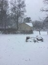
Congrats to everyone getting snow...hoping to see multiple reports of 10"+ in the Carolina's.
View attachment 192529


How does Roxboro always get more snow than here, no matter what the setup is? It baffles the mind.To be fair Raleigh had better snows the past few years than the Charlotte area. I have about 2.5 in Person County
No we aren’t…this hole isn’t movingYour getting 4-7. Hang tight. 1 pm should start going triangle. And going good this afternoon, tonight


Yes. It feels like I scouted a perfect ski weekend and I’ve just arrived up at Sugar mountain to heavy NW flow. This is rare stuff and we may not see it again for another 15+ years. Powder only comparable to January 2011It’s absolutely dumping snow here. We are healing.
I can't believe it still has 2 inches here.


It seems to be slowly filling in the precip hole over us, so perhaps we can still end up with 2-4” or so.I can't believe it still has 2 inches here.

I hope so but really hard to believe it for the Triangle.Future radar. Been doing great job so far. So im gonna keep riding it. Better than cams imo.
This is 2:11 pm. At 1pm ish, snow should start breaking out around triangle. Be light. But its covered dry hole by 2:11 pm
View attachment 192559
Fast forward to 5:30 pm and notice bands darker colored,coastal is cranking and upper low is giving in slowly.
View attachment 192563
I can't believe it still has 2 inches here.
Future radar. Been doing great job so far. So im gonna keep riding it. Better than cams imo.
This is 2:11 pm. At 1pm ish, snow should start breaking out around triangle. Be light. But its covered dry hole by 2:11 pm
View attachment 192559
Fast forward to 5:30 pm and notice bands darker colored,coastal is cranking and upper low is giving in slowly.
View attachment 192563
Coming down good here and we are over 2”, probably close to 2.5”. Had to run get a prescription for my wife and a 25-minute round trip took me 1 hour, 10 minutes. Definitely not great driving conditions.I don't know how but it keeps getting heavier. Closing in on 2" now fast.
Midnight.That’s hard to fathom 5pm and still cranking. Do you have the radar that shows how long it goes through the triad? You’ve been great to follow through this storm.
Sent from my iPhone using Tapatalk


What is the source for future radar?Future radar. Been doing great job so far. So im gonna keep riding it. Better than cams imo.
This is 2:11 pm. At 1pm ish, snow should start breaking out around triangle. Be light. But its covered dry hole by 2:11 pm
View attachment 192559
Fast forward to 5:30 pm and notice bands darker colored,coastal is cranking and upper low is giving in slowly.
View attachment 192563
We’re gonna have double digits if that ends up happening.Midnight.