When Mobile NWS start issuing winter storm watches you know it’s a very unusual setup.
Winter Weather Advisory is what they said may be issued. Still rare:
Special Weather Statement
National Weather Service Mobile AL
944 PM CST Sat Feb 13 2021
ALZ051>053-MSZ067-075-076-141200-
Choctaw-Washington-Clarke-Wayne-Perry-Greene-
Including the cities of Butler, Lisman, Silas, Chatom, Millry,
Grove Hill, Jackson, Thomasville, Waynesboro, Beaumont,
New Augusta, Richton, Leakesville, and McLain
944 PM CST Sat Feb 13 2021
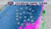
Two periods of wintry weather are possible over portions of
interior southeast Mississippi and interior southwest Alabama
from Sunday night through Monday evening. First, freezing rain or
freezing drizzle is possible over Choctaw and Wayne counties late
Sunday night into early Monday morning. A Winter Weather Advisory
may soon be required for Choctaw and Wayne counties during this
period. Secondly, freezing rain is looking increasingly likely to
develop Monday afternoon and persist into Monday evening before
the precipitation comes to an end. This second period of wintry
precipitation looks to affect portions of Wayne, Perry, Greene,
Choctaw, Washington and Clarke counties. A Winter Storm Watch will
likely soon be issued for this general portion of the area. Stay
tuned!
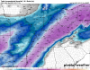
Wind chill values will drop to the single digits across portions
of interior southeast Mississippi and interior southwest Alabama
Monday night into early Tuesday morning. A Wind Chill Advisory may
become necessary. Black Ice will also be possible Monday night
as lingering precipitation on roads flash-freeze as an arctic
airmass flows into the area.