Bone dry when I drove through these little podunk towns earlier 
One day they might get a stoplight! Currently 72 degreesBone dry when I drove through these little podunk towns earlier View attachment 148172


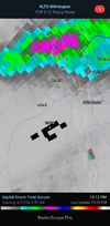
One of the strongest thunderstorms I ever witnessed happened July 1st 201212 years ago today we were cooking View attachment 148175
Oof. Right in time for our beach trip. I assume that’s from a TS?
Much of it. But I wouldn't worry too much about it. I'll go back to light greens and dark blues on the next run.Oof. Right in time for our beach trip. I assume that’s from a TS?


I remember that evening well. I had a high of 104 that day with a max heat index of 118. You could just see that line of storms developing on radar just east of the mountains and knew it was just gonna blow upOne of the strongest thunderstorms I ever witnessed happened July 1st 2012
That was a crazy day for sure. I remember looking at the radar around 6pm and thinking that we would stay dry. Then by 7pm storms were everywhere and were severe. I think we had at least 3 outflow boundaries come together over the Spartanburg, Gaffney, and Union area.I remember that evening well. I had a high of 104 that day with a max heat index of 118. You could just see that line of storms developing on radar just east of the mountains and knew it was just gonna blow up
Over this way, we had two outflow boundaries come together just to my west near Charlotte, and then the outflow from that came together with the sea breeze front that had held togetherThat was a crazy day for sure. I remember looking at the radar around 6pm and thinking that we would stay dry. Then by 7pm storms were everywhere and were severe. I think we had at least 3 outflow boundaries come together over the Spartanburg, Gaffney, and Union area.
I think that's because the trough that is going to come through will arrive later than first anticipated and whatever develops will not have the heat of the day to work with. Precipitation chances have also been delayed from Saturday into Sunday to Sunday into Monday now. There will be plenty of moisture for this trough to work with so hopefully many of us will get some of the rain we need. My front lawn is the brownest I remember seeing it in recent memory and my garden is pretty much toast for the time being. Some of the tree limbs on the Mulberry tree in my backyard are starting to die.Sunday seems more hit and miss than I had hoped. Winners and lovers as usual, hopefully pattern breaks down soon
Maybe the heat and lack of rain are getting to me but I'm all aboard. I'm concerned about a couple of things but we don't get those jet dynamics alot in the summerSunday seems more hit and miss than I had hoped. Winners and lovers as usual, hopefully pattern breaks down soon