weatherfide
Member
- Joined
- Jan 5, 2017
- Messages
- 3,282
- Reaction score
- 4,878
Just got .87" in a hurry! Finally! Been a long time. Of course, the Tempest will probably adjust that amount some, but still a good downpour!
Turn your nearcast off on your tempest and it won't adjust and it'll give you what it gotJust got .87" in a hurry! Finally! Been a long time. Of course, the Tempest will probably adjust that amount some, but still a good downpour!
Dude! I turned off near cast and it says i received 2.35 in. of rain! With NC on it shows 1.35 in. That's a crazy difference. Maybe NC is more accurate?Turn your nearcast off on your tempest and it won't adjust and it'll give you what it got

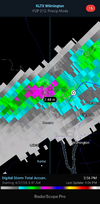
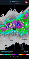
Horrible day for my backyard

I sure hope so. Right now, I'll believe it when it happens. I posted the latest GFS run for this weekend's totals, but here is the 12z Euro:It looks like Sunday will be the best chance of widespread rain which is badly needed in Central North Carolina. The RDU office is giving us a 70% chance now. Today certainly was disappointing for most of us. At least there are chances for pop up thunderstorms Friday and Saturday if the Sunday event does not materialize.
Loading…
www.weather.gov

Buddy you must be living right to get that much..37 for June, I've got an outside shot Sunday to up that total but .37 for the entire month of June just as well be zero. Unreal
Sunday should be such an easy slam dunk for a solid line of storms and a widespread 1-2 inches of rain. This setup though has a tendency to leak the prefrontal trough to our east through composite outflows or differential heating. I'm worried we see a copy/paste of today but if we can get the storm initiation to out west with pwats of 2.5, highs in the mid 90s, dews in the mid 70s storms should be efficient rain producersI sure hope so. Right now, I'll believe it when it happens. I posted the latest GFS run for this weekend's totals, but here is the 12z Euro:
View attachment 148170
Has similarities with the GFS.