Brent
Member
Really starts around 2 minutes with the power going out around 4
It's forecast to hit 100 both tomorrow and Tuesday in Dallas !It's kind of funny, really.
Last week, it was looking like DFW would be seeing days upon days of 100*F+ weather and sunny/dry conditions with no end in sight. There was so much hype about record-breaking oppressive heat.
Fast forward to today and not only has DFW yet to hit 100*F+, but it's only been "seasonably warm" and there's a good chance it may not even happen at all with this "heat wave" before it ends on Wednesday. Plus, much of the period has been pretty cloudy due to persistent convective debris and/or post-outflow stratus clouds.
EDIT: The long-advertised heat wave did verify for San Antonio, Austin and (to a lesser extent) Houston though. And granted, the humidity was certainly imrpessive although actual temps fell well short of expectations.
It's forecast to hit 100 both tomorrow and Tuesday in Dallas !
And where is this???? Why do you post this stuff without reference to where you are? Is someone after you?Just had a powerful 70 mph storm that came through
He is in Southwest Alabama.And where is this???? Why do you post this stuff without reference to where you are? Is someone after you?


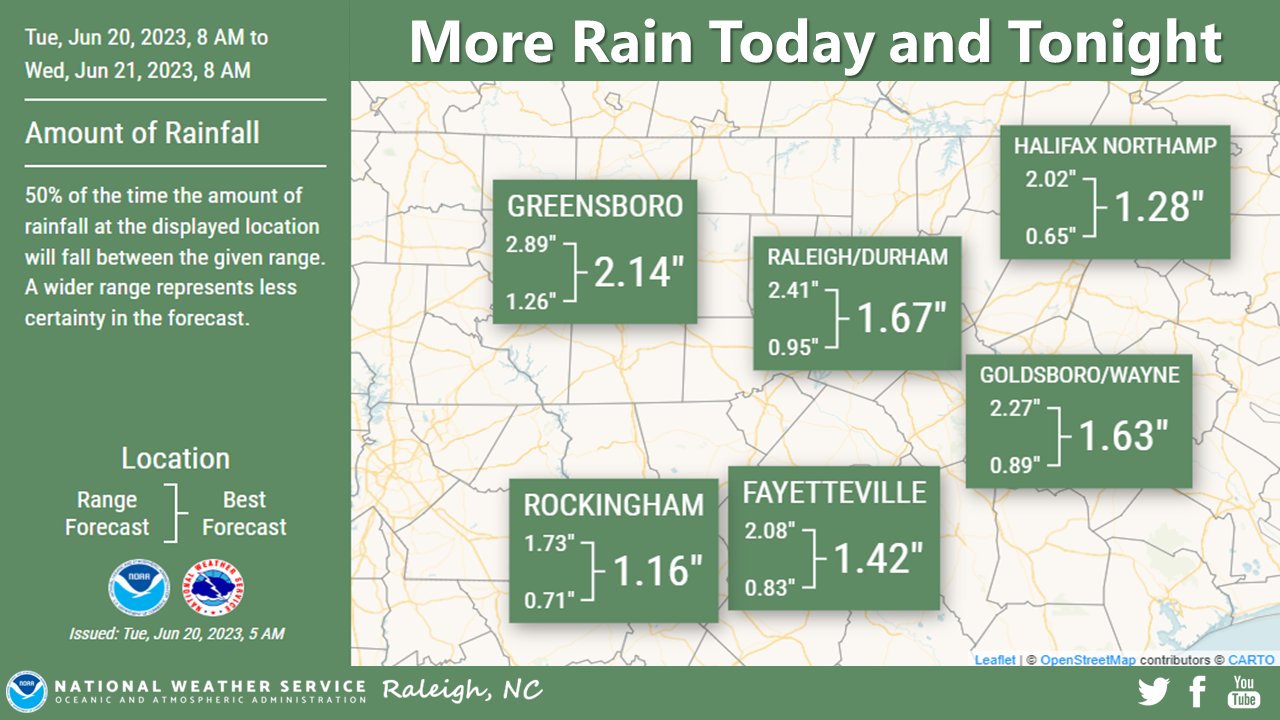
It definitely has not rained as much as forecast so far but I am sure that will change here soon. I’m perfectly fine with only getting 3-4 inches of rain instead of 5-6 or more.Round 1 was a no show here and round 2 does not look to happen this afternoon as forecast.
I'll be shocked if anyone sees 2 out of this and many will get under .25. Typical summer storms is all this will be. East of i-77 may be another story though.It definitely has not rained as much as forecast so far but I am sure that will change here soon. I’m perfectly fine with only getting 3-4 inches of rain instead of 5-6 or more.
Probably a little more coverage than just afternoon storms. But I would be shocked if the 7 inch totals are as widespread as models were indicating. This is no comparison to the widespread heavy rain tropical systems bring. Just tropical downpours off and on throughout the week with an awful lot of dry time in between. I'll stick with 2-3 total.I'll be shocked if anyone sees 2 out of this and many will get under .25. Typical summer storms is all this will be. East of i-77 may be another story though.


Atleast somebody in the upstate is getting sprinkles! ?Round 1 was a no show here and round 2 does not look to happen this afternoon as forecast.

I didn’t think there would be much west of I-77 today because the flow around the upper low has been from the west and wsw. Now that the low is dropping south, the flow has already switched to southwesterly and we’re beginning to see more development back over western sections. This will continue to increase as the flow becomes southeasterly tomorrow and increases upslope.The GFS is trending down for this event west of I-77 and it will probably continue to do so.
You're so ridiculous.... maybe the Euro will verify for you, seems you fail to mention that oneThe 6z GFS continues the trend. This event may already be about over in the GSP county warning area outside of the mountains and upslope areas north of I-85. It shows less than 1.25 of additional rain now for many of us through hour 108.