• Hello, please take a minute to check out our awesome content, contributed by the wonderful members of our community. We hope you'll add your own thoughts and opinions by making a free account!

Pattern June 2023 Thread

It's kind of funny, really.

Last week, it was looking like DFW would be seeing days upon days of 100*F+ weather and sunny/dry conditions with no end in sight. There was so much hype about record-breaking oppressive heat.

Fast forward to today and not only has DFW yet to hit 100*F+, but it's only been "seasonably warm" and there's a good chance it may not even happen at all with this "heat wave" before it ends on Wednesday. Plus, much of the period has been pretty cloudy due to persistent convective debris and/or post-outflow stratus clouds.

EDIT: The long-advertised heat wave did verify for San Antonio, Austin and (to a lesser extent) Houston though. And granted, the humidity was certainly imrpessive although actual temps fell well short of expectations.
 
Last edited:
It's kind of funny, really.

Last week, it was looking like DFW would be seeing days upon days of 100*F+ weather and sunny/dry conditions with no end in sight. There was so much hype about record-breaking oppressive heat.

Fast forward to today and not only has DFW yet to hit 100*F+, but it's only been "seasonably warm" and there's a good chance it may not even happen at all with this "heat wave" before it ends on Wednesday. Plus, much of the period has been pretty cloudy due to persistent convective debris and/or post-outflow stratus clouds.

EDIT: The long-advertised heat wave did verify for San Antonio, Austin and (to a lesser extent) Houston though. And granted, the humidity was certainly imrpessive although actual temps fell well short of expectations.
It's forecast to hit 100 both tomorrow and Tuesday in Dallas !
 
It's forecast to hit 100 both tomorrow and Tuesday in Dallas !

It's been forecasted to hit 100*F every day in Dallas since last weekend, until it didn't happen for the reasons mentioned in my post.

EDIT: The departure for June as of yesterday is only a whopping +0.1*F and the warmest days (last Sunday with a high of 99*F) only had a departure of +3.7*F
 
Wow! From KFFC< KATL

.LONG TERM...
(Monday night through Saturday)
Issued at 403 AM EDT, Sun Jun 18 2023

Key Messages:

Starting Monday, a wet pattern sets up over the forecast region
that will keep numerous to widespread rain showers and
thunderstorms in the forecast each day across the forecast area.

Overall, rain totals from 2.5 to 5 inches on average are forecast
through next Sunday, although locally higher amounts up to 7
inches may be possible.
 
Move if need be! I had to work and adjust this! It wouldn’t let me load original pic0EF285E6-7785-4F43-9CFC-4FE9709A76D7.jpeg
 
Key Messages:

- Cloudy and rainy weather is forecast this week, with rainfall
totals likely (> 90% chance) exceeding 2 inches by next weekend.

- Expect below average temperatures all week, with high temperatures
running 5 to 15 degrees below average.

Dreary Weather Tuesday through Next Weekend:

With an omega block over the Lower 48 and a nearly stationary upper
level trough over Alabama and Mississippi pumping moisture northward
from the Gulf, it will feel like we are living in a "southern
version, Seattle" this week. Though it is hard to imagine us not
seeing the sun for six straight days in late June, that is what a
good portion of the ensemble guidance is leaning towards. The mean
cloud cover from the 80 EPS and GEFS members keeps the region under
80 to 100 percent cloud cover through at least Sunday.
 
Gotta love how efficient this tropical airmass is at building up rainfall totals. So far I’ve had two downpours in the last couple hours, totally about 20 minutes of rain and already have had .6”
 
It definitely has not rained as much as forecast so far but I am sure that will change here soon. I’m perfectly fine with only getting 3-4 inches of rain instead of 5-6 or more.
I'll be shocked if anyone sees 2 out of this and many will get under .25. Typical summer storms is all this will be. East of i-77 may be another story though.
 
I'll be shocked if anyone sees 2 out of this and many will get under .25. Typical summer storms is all this will be. East of i-77 may be another story though.
Probably a little more coverage than just afternoon storms. But I would be shocked if the 7 inch totals are as widespread as models were indicating. This is no comparison to the widespread heavy rain tropical systems bring. Just tropical downpours off and on throughout the week with an awful lot of dry time in between. I'll stick with 2-3 total.
 
The GFS is trending down for this event west of I-77 and it will probably continue to do so.
 
The GFS is trending down for this event west of I-77 and it will probably continue to do so.
I didn’t think there would be much west of I-77 today because the flow around the upper low has been from the west and wsw. Now that the low is dropping south, the flow has already switched to southwesterly and we’re beginning to see more development back over western sections. This will continue to increase as the flow becomes southeasterly tomorrow and increases upslope.
 
The 6z GFS continues the trend. This event may already be about over in the GSP county warning area outside of the mountains and upslope areas north of I-85. It shows less than 1.25 of additional rain now for many of us through hour 108.
 
I've been in OKC since Sunday night due to the complete mess in Tulsa after the storm(had decided I was gonna try and stay in a hotel and failed because apparently everyone else had the same idea at the few that had power and finally just gave up and drove an hour to the edge of OKC) The estimate on my power restoration at the apartment is Friday and the heat indexes are climbing til then ?. I have to go home today and really hoping it's way sooner than that. I did manage to get a hotel in Tulsa tonight through Friday if needed but yeah this is rough.
 
The 6z GFS continues the trend. This event may already be about over in the GSP county warning area outside of the mountains and upslope areas north of I-85. It shows less than 1.25 of additional rain now for many of us through hour 108.
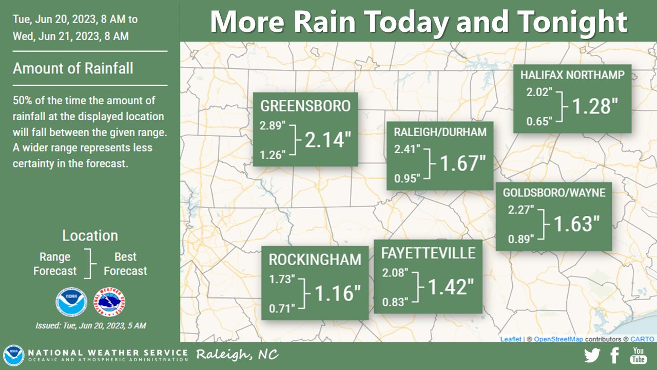
You're so ridiculous.... maybe the Euro will verify for you, seems you fail to mention that one

qpf_acc-imp.us_ma.png
 
Back
Top